


Needingworth, United Kingdom
Needingworth is a town of 2,191 people in England, United Kingdom.
Why visit Needingworth
Townapedia lists 6 museums and landmarks, 9 parks and trails and 11 places to eat in and around town.
Highlights include Obelisk at Stocks Bridge, The Manor, Fen Drayton Lakes and Houghton Meadows.
Weather in Needingworth
Forecast from MET Norway (CC BY 4.0). Full forecast
About Needingworth
Needingworth is a village in Cambridgeshire, England. Needingworth lies approximately 7 miles (11 km) east of Huntingdon and just west of the Prime Meridian, as seen in its latitude below. Needingworth is in the civil parish of Holywell-cum-Needingworth. Needingworth is situated within Huntingdonshire which is a non-metropolitan district of Cambridgeshire as well as being a historic county of England.
From the Wikipedia article Needingworth (this version), under CC BY-SA 4.0.
Museums and landmarks6


Swavesey Priory
Monument and historic site · 2.1 mi
Priory in Swavesey, South Cambridgeshire, England, UK
Parks, trails and playgrounds9
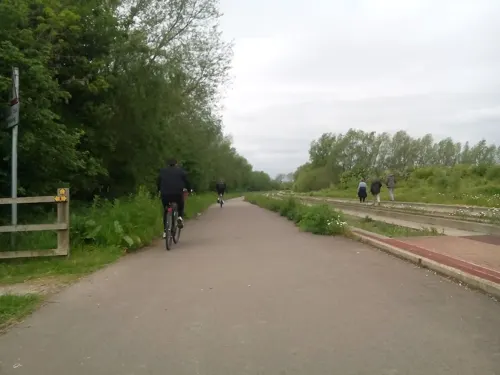
Fen Drayton Lakes
Park · 1.6 mi
RSPB nature reserve in the United Kingdom






Restaurants and cafes11


Churches and places of worship5

All Saints Church, St Ives
Church · 2.1 mi
Church in St Ives, Huntingdonshire, Cambridgeshire, England, UK


More about Needingworth
Arts and culture
There is only one shop, currently a 'One Stop', which is also a Post Office on the Needingworth high street. There are also two pubs (not including the Ferry Boat Inn in Holywell) in Needingworth, The Pike and Eel and The Queen's Head.
There is a Church-of-England primary school, a village hall with bowls club and various good walks in the area. Also tennis courts.
The Villager is the local newsletter of the area, a copy of which is delivered free to every household in the parish of Holywell-cum-Needingworth.
The drama club is the Wellworth Players, a long established amateur theatre club taking their name from Needingworth and Holywell. They have won several awards for their plays and pantomimes. These events are staged in Needingworth Village Hall.
This is the only settlement in the world to carry the name Needingworth.
Famous residents include Ambrose Nicholas, a former Lord Mayor of London.
From the Wikipedia article Needingworth, under CC BY-SA 4.0.
Shopping2
Gas and EV charging1
Schools, colleges and libraries1
Map of Needingworth
35 places. The map loads OpenStreetMap tiles when you open it.
Getting there and nearby towns
Cambridge City Airport (CBG) is the nearest airport with scheduled flights listed in OpenStreetMap, 12 miles away.
- Saint Ives 2 mi west, about 3 min by car
- Swavesey 2 mi southeast, about 4 min by car
- Earith 3 mi northeast, about 5 min by car
- Houghton 4 mi west, about 6 min by car
- Oakington 6 mi southeast, about 10 min by car
- Huntingdon 7 mi west, about 11 min by car
- Chatteris 9 mi north, about 15 min by car
- Wilburton 9 mi east, about 14 min by car
- Alconbury 10 mi west, about 16 min by car
- Cambridge 11 mi southeast, about 18 min by car
Drive times are estimates from straight-line distance, not routes.
Towns near Needingworth


Keep exploring
Local news
Headlines from INDB.
Reviews, tips and questions
Loading what members have shared...
Sources and licences
- GeoNames (CC BY 4.0): population, coordinates, regions and time zone
- Mapillary (see each image): photos
- OpenStreetMap contributors (ODbL 1.0): places, airports, map data
- Wikidata (CC0 1.0): elevation, founding date, time zone, website, landmarks and historic places
- Wikimedia Commons (see each image): photos
- Wikipedia (CC BY-SA 4.0): overview and history text
Photo credits
- UK Holywell Needingworth, Uksignpix, CC BY-SA 3.0
- Cmglee St Ives Market Hill, Cmglee, CC BY-SA 3.0
- Godmanchester to St Ives 090 The Manor House gardens, Hemingford Grey (22164131578), Peter O'Connor aka anemoneprojectors, CC BY-SA 2.0
- Godmanchester to St Ives 198 Houghton Meadows (22653366042), Peter O'Connor aka anemoneprojectors, CC BY-SA 2.0
- Street-level photo, adam2, CC BY-SA 4.0
- Street-level photo, adam2, CC BY-SA 4.0
- Street-level photo, adam2, CC BY-SA 4.0
- Street-level photo, cyclestreets, CC BY-SA 4.0
- Street-level photo, adam2, CC BY-SA 4.0
- Street-level photo, adam2, CC BY-SA 4.0
- Street-level photo, adam2, CC BY-SA 4.0
- Street-level photo, adam2, CC BY-SA 4.0
- Street-level photo, adam2, CC BY-SA 4.0
- Street-level photo, adam2, CC BY-SA 4.0
- Street-level photo, adam2, CC BY-SA 4.0
- Street-level photo, adam2, CC BY-SA 4.0
- Street-level photo, adam2, CC BY-SA 4.0
- Street-level photo, adam2, CC BY-SA 4.0
- Street-level photo, adam2, CC BY-SA 4.0
- Street-level photo, adam2, CC BY-SA 4.0
Page built November 10, 2026. Spotted a mistake? Tell us or suggest a place.