

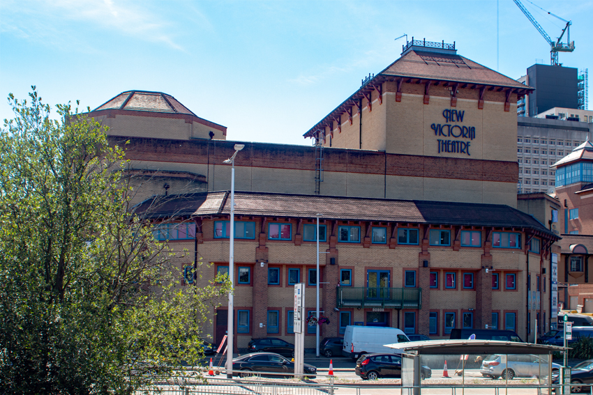


Ottershaw, United Kingdom
Ottershaw is a town of 3,451 people in England, United Kingdom.
Why visit Ottershaw
Townapedia lists 5 museums and landmarks, 15 parks and trails, 25 places to eat and 11 attractions in and around town.
Highlights include Chertsey Bridge, New Victoria Theatre, Brooklands Museum and London Bus Museum.
Weather in Ottershaw
Forecast from MET Norway (CC BY 4.0). Full forecast
About Ottershaw
Ottershaw is a village in the Borough of Runnymede in Surrey, England, approximately 32 km (20 mi) southwest of central London. The village developed in the mid-19th century from a number of separate hamlets and became a parish in its own right in 1871.
From the Wikipedia article Ottershaw (this version), under CC BY-SA 4.0.
Photos of Ottershaw


Things to do11

Chertsey Bridge
Bridge · 2.5 mi
Classical bridge over the Thames in England that has stood since 1785

New Victoria Theatre
Cinema and theater · 3.2 mi
Theatre in Woking, England


Thorpe Park
Monument and historic site · 3.0 mi
Amusement park in Thorpe, Surrey, England

Museums and landmarks5

Brooklands Museum
Museum · 2.8 mi
Sports museum in Weybridge, Surrey, England, United Kingdom

London Bus Museum
Museum · 2.8 mi
Transport museum located at Brooklands, Weybridge, England, United Kingdom

The Lightbox
Museum · 3.1 mi
Museum in Surrey, England, United Kingdom

York Column
Monument and historic site · 3.2 mi
Building in Elmbridge, Surrey, England, UK

Muslim Burial Ground, Horsell Common
Monument and historic site · 2.4 mi
Former cemetery and current peace garden in Woking, Surrey, England, UK
Parks, trails and playgrounds15


Milford Green and Coxhill Green
Park · 3.1 mi
Nature Reserves in Chobham, Surrey, British Columbia

Sayes Court Open Space
Park · 1.5 mi
Benefaction of James Paine. In 1770s 'Seven Dials', St Giles a haunt of cut-throats, thieves and prostitutes. In 1773, the city...
3 more on the map.
Restaurants and cafes25
Mr. Fresh / 19 Daddy Ltd
Restaurant · 0.9 mi
8 Ongar Parade, Addlestone
Mo-Fr 10:00-14:00; Sa,Su off



13 more on the map.
History
The Ottershaw Society has carried out a comparative, now and then, survey of the village comprising more than 1,000 images (photographs and illustrations) from the mid-19th century to the present time, older residents' memories and various other historical written material. The Victoria County History collaborative historians' work captures the village under its Chertsey entries, as with Addlestone, considering in its 1910s edition some ties to Chertsey remained strong.
From the History section of Ottershaw on Wikipedia, under CC BY-SA 4.0.
More about Ottershaw
Economy
Ottershaw is largely a mixture of a London commuter belt and a retirement settlement. Its nearest passenger trains to London leave from Addlestone railway station, centred 2.5 miles (4.0 km) east, on a branch line, with two others on a main line a slightly greater distance to the south —; the principal one which has frequent, semi-fast services to London being West Byfleet.
From the Wikipedia article Ottershaw, under CC BY-SA 4.0.
Notable people from Ottershaw
- Oliver Jamesactor, musician
Born in Ottershaw, according to Wikidata (CC0). Each name links to its Wikipedia article.
Churches and places of worship10
Shopping1
Gas and EV charging2
Schools, colleges and libraries11
Lyne and Longcross Church of England Aided Primary School
School · Anglican · 1.5 mi
Lyne Lane, Chertsey
Healthcare6
Map of Ottershaw
86 places. The map loads OpenStreetMap tiles when you open it.
Getting there and nearby towns
Heathrow Airport (LHR) is the nearest airport with scheduled flights listed in OpenStreetMap, 8 miles away.
- Addlestone 2 mi east, about 3 min by car
- Chertsey 2 mi northeast, about 3 min by car
- Weybridge 3 mi east, about 5 min by car
- Woking 3 mi southwest, about 5 min by car
- Shepperton 4 mi northeast, about 7 min by car
- Staines 5 mi north, about 8 min by car
- Egham 5 mi north, about 8 min by car
- Walton-on-Thames 5 mi east, about 8 min by car
- Sunbury-on-Thames 6 mi northeast, about 9 min by car
- Ashford 6 mi northeast, about 9 min by car
Drive times are estimates from straight-line distance, not routes.
Towns near Ottershaw


Keep exploring
Local news
Headlines from INDB.
Reviews, tips and questions
Loading what members have shared...
Sources and licences
- GeoNames (CC BY 4.0): population, coordinates, regions and time zone
- Mapillary (see each image): photos
- OpenStreetMap contributors (ODbL 1.0): places, airports, map data
- Wikidata (CC0 1.0): elevation, founding date, time zone, website, landmarks and historic places
- Wikimedia Commons (see each image): photos
- Wikipedia (CC BY-SA 4.0): overview and history text
Photo credits
- Chertsey Bridge, Alistair young, CC BY 2.0
- New Victoria Theatre, Woking, Murgatroyd49, CC BY-SA 4.0
- The Lightbox (c) Ian Rudgewick Brown - cropped, The Lightbox, CC BY-SA 4.0
- York Column, Weybridge - cropped, Mertbiol, CC0
- Woking-TownSquare, AlanFord at English Wikipedia, Public domain
- Horsell Church1, Akoliasnikoff, CC BY-SA 4.0
- Christ Church, Guildford Road, Ottershaw (NHLE Code 1260037) (June 2015) (2), User:Hassocks5489, CC0
- Rhoda McGaw Auditorium front 1975, Woking Borough Council, CC0
- Gasteria retusa RSA, S Molteno, CC BY-SA 4.0
- Haworthia mirabilis var mirabilis - De Hoop, S Molteno, CC BY-SA 4.0
- 1 Tulista minima 5, S Molteno, CC BY-SA 4.0
- Thorpe Park Resort, Smithr32, CC BY-SA 4.0
- Brooklands Museum, 22 July 2012, Colin Smith, CC BY-SA 2.0
- London Bus Museum Transportfest 2013 140 (10382998473), MANHATTAN RESEARCH INC (MANHATTAN RESEARCH INC) from S E A T T L E , S E A T T L E, CC BY 2.0
- Pylons at Chertsey Meads - panoramio, Maxwell Hamilton, CC BY-SA 3.0
- Street-level photo, jpennycook, CC BY-SA 4.0
- Street-level photo, jpennycook, CC BY-SA 4.0
- Street-level photo, jpennycook, CC BY-SA 4.0
- Street-level photo, jpennycook, CC BY-SA 4.0
- Street-level photo, jpennycook, CC BY-SA 4.0
- Street-level photo, jpennycook, CC BY-SA 4.0
- Street-level photo, jpennycook, CC BY-SA 4.0
- Street-level photo, jpennycook, CC BY-SA 4.0
- Street-level photo, jpennycook, CC BY-SA 4.0
- Street-level photo, jpennycook, CC BY-SA 4.0
- Street-level photo, jpennycook, CC BY-SA 4.0
- Street-level photo, jpennycook, CC BY-SA 4.0
- Street-level photo, jpennycook, CC BY-SA 4.0
- Street-level photo, jpennycook, CC BY-SA 4.0
- Street-level photo, jpennycook, CC BY-SA 4.0
- Street-level photo, jpennycook, CC BY-SA 4.0
- Street-level photo, jpennycook, CC BY-SA 4.0
- Street-level photo, jpennycook, CC BY-SA 4.0
- Street-level photo, jpennycook, CC BY-SA 4.0
- Street-level photo, jpennycook, CC BY-SA 4.0

Page built November 10, 2026. Spotted a mistake? Tell us or suggest a place.