
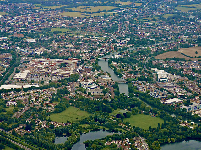


Why visit Staines
Townapedia lists 28 museums and landmarks, 28 parks and trails, 164 places to eat, 7 places to stay and 7 attractions in and around town.
Highlights include Chertsey Bridge, Staines Bridge, Flying Fish and Air Forces Memorial.
Weather in Staines
Forecast from MET Norway (CC BY 4.0). Full forecast
About Staines
Staines-upon-Thames, commonly known simply as Staines, is a market town in northwest Surrey, England, around 17 miles (28 kilometres) west of central London. It is in the Borough of Spelthorne, at the confluence of the River Thames and Colne. Historically part of Middlesex, the town was transferred to Surrey in 1965. Staines is close to Heathrow Airport and is linked to the national motorway network by the M25 and M3.
From the Wikipedia article Staines-upon-Thames (this version), under CC BY-SA 4.0.
Photos of Staines


Things to do7

Chertsey Bridge
Bridge · 3.0 mi
Classical bridge over the Thames in England that has stood since 1785

Staines Bridge
Bridge · 0.5 mi
Bridge over the Thames in Runnymede, Surrey, England, UK

Staines Railway Bridge
Bridge
Bridge over the Thames in the United Kingdom

Thorpe Park
Monument and historic site · 1.8 mi
Amusement park in Thorpe, Surrey, England

Museums and landmarks28


Air Forces Memorial
Monument and historic site · 2.6 mi
Memorial in Englefield Green, Surrey, England, UK

Ankerwycke Priory
Monument and historic site · 2.3 mi
Benedictine nunnery with associated moat and fishponds

Kennedy Memorial
Monument and historic site · 2.9 mi
Memorial to John F. Kennedy in Runnymede, England, United Kingdom




HK Daybreak
Monument and historic site · 0.7 mi
The last vessel to be built in the UK to carry cargo by sail
16 more on the map.
Parks, trails and playgrounds28

Arthur Jacob Nature Reserve
Park · 3.0 mi
Local nature reserve located in Horton





16 more on the map.
Restaurants and cafes164
Purple Lounge
Restaurant · Curry, Indian
116 High Street, Staines-upon-Thames
Tu-Sa 17:00-22:30; Su 17:00-21:00

Caffe Gondola
Restaurant · Italian · 1.8 mi
168 High Street, Egham
Mo-Su 10:00-22:30; Fr,Sa 10:00-23:00
M2 Pizza Pasta
Restaurant · Pizza, Pasta · 1.8 mi
15 Church Road, Ashford
Mo-Sa 11:30-23:00; Su 11:30-22:00
MasalaBot
Restaurant · Indian · 0.4 mi
16-18 High Street, Staines-upon-Thames
Mo-Su 12:00-15:00,18:00-22:00
Polow Restaurant
Restaurant · Persian · 1.7 mi
72 High Street, Egham
Tu-Sa 13:00-23:00; Su 13:00-22:00
Royal Grill
Restaurant · Grill · 1.1 mi
37 Edinburgh Drive, Staines-upon-Thames
We-Sa 12:00-22:30; Su 16:00-22:30
163 Restaurant
Restaurant · 1.8 mi
163 High Street, Egham
Tu-Th 11:30-21:00; Fr 11:30-21:30; Sa 09:00-21:30; Su 09:00-16:00

Bass & Caird
Brewery and winery
83 Laleham Road, Staines-upon-Thames
Mo-Fr 10:00-19:00; Sa 10:00-17:00

Caffè Nero
Cafe · Coffee Shop
59 High Street, Staines-upon-Thames
Mo-Fr 07:00-17:30; Sa 07:00-18:30; Su 08:00-17:00
Caffè Nero
Cafe · Coffee Shop · 1.7 mi
25 The Precinct, High Street, Egham
Mo-Fr 06:30-17:30; Sa-Su 07:30-17:30
Cornelis Bistro
Restaurant · 0.4 mi
1 Clarence Street, Staines-upon-Thames
Mo-We 08:00-17:00; Th 08:00-22:00; Fr-Sa 08:00-00:00; Su 08:00-18:00
152 more on the map.
History
The earliest evidence of human activity in Staines is from the Paleolithic. Flint blades, along with reindeer and horse bone fragments, have been found during excavations at Church Lammas, to the west of the town centre. During the Mesolithic, the area around Staines is thought to have been covered with a dense pine and birch forest. A Neolithic causewayed enclosure, about 800 metres (1⁄2 mile) west of St Mary's Church, was identified by aerial photography in 1959. The site, on a gravel island in the Colne river delta, 16 m (52 ft) AOD, consisted of two concentric, subcircular ditches, with a probable main entrance at the southeastern side. Pottery sherds and worked flints were found on the site, as well as fragments of human bone. Other Neolithic artefacts from the local area include fragments of a jadeite axe, discovered on Staines Moor in the early 1980s, tentatively dated to c. 3500 – c. 1700 BCE.
Read more of the history
Deverel–Rimbury pottery from the Church Lammas lands indicates that the Staines area was settled in the Bronze Age and a roundhouse from the same period has been identified at Laleham. Two round barrow ring ditches, one of which had a cremation burial at the centre, were found at Knowle Green in 2021. A further ring ditch, around 21 m (69 ft) in diameter, was found during excavations of the Majestic House site, close to the eastern end of the High Street. A Bronze Age field system at Hengrove Farm was also cultivated during the Iron Age, but fell out of use around the start of the Roman period. There is also evidence of an early Iron Age enclosure on Staines Moor and finds from the site include pottery sherds, flints and animal bones, with evidence of burning having taken place there. Since Staines is located on the low-lying floodplain of the Thames, it is likely that historical flooding events have destroyed much of the archaeological evidence of pre-Roman human activity in the town centre.
The Roman road from London to Silchester crossed the Thames in the Staines area. Both the Thames and Colne are thought to have had multiple channels during this period, which may have necessitated the building of more than one bridge. There was a settlement in the area surrounding the modern High Street and, although the date of its foundation is uncertain, the earliest archaeological evidence is from 54–96 AD, corresponding to the reign of Nero and the period of the Flavian Dynasty.
By the mid-2nd century, Staines had increased in size and prosperity and the early Romano-British roundhouses had been replaced by stone buildings with flint and rag-stone foundations. Fragments of painted, plastered wall and floors of opus signinum have been uncovered, and the presence of tesserae indicates that at least one building had a mosaic floor. A collyrium stamp, found during an excavation of 73–75 High Street, suggests that there was a healer living in the town, who could have administered to the wider local population. Staines declined towards the end of the 2nd century, possibly as a result of an increased incidence of winter flooding. Nevertheless, Romano-British settlement activity continued until the early 4th century, although the town appears to have been smaller and less important than it had been in the first half of the Roman period.
Following the end of Roman rule in Britain, the main settlement at Staines appears to have shifted from the High Street area to the Binbury area surrounding St Mary's Church. Archaeological evidence, including pits, ditches and pottery sherds suggests that there was a permanent settlement in this area by the mid-Saxon period and there may have been a marketplace at the northern end of Church Street. Staines may have been a fortified burh and the location of a minster church. A late-Saxon execution cemetery on London Road, containing the incomplete remains of up to thirty skeletons, suggests that the town was also an important local centre for the administration of justice.
For much of the early Saxon period, the Thames through Staines marked the border between Middlesex (to the north) and Surrey (to the south). In the 9th century, the river was used by Danish Viking raiders to travel into the heart of England. In 993, the Norwegian King, Olaf Tryggvason, sailed up the Thames to Staines with a fleet of 93 ships. In 1009, a large army of Vikings attacked Oxford and retreated back along the banks of the Thames, crossing the river at Staines.
Between 1042 and 1052, Edward the Confessor rebuilt Westminster Abbey as a royal burial church and endowed it with around 60 estates in the south east of England. Staines was one of the properties granted to the Abbey and remained in its possession until the Reformation. In 1086, the manor appears in the Middlesex section of Domesday Book as Stanes. In 1086, the manor had land for 24 ploughs, six mills and woodland for 30 pigs. It provided an annual income of £35 for the Abbey. Since it was relatively close to Westminster, Staines acted as a home farm, providing for the abbot's personal household. 13th-century abbey records indicate that a market was taking place by 1218 and, in 1225, there were 46 burgesses living in the settlement, suggesting that Staines had become an important local centre.
Westminster Abbey was dissolved in 1540 and Staines then became a possession of the Crown, allowing Henry VIII to extend his Windsor hunting grounds further to the east. In 1613, James I granted the manor to Thomas Knyvet, who had arrested Guy Fawkes at the Palace of Westminster eight years earlier. Following Knyvet's death, Staines passed to Sir Francis Leigh and, following the Restoration of the Monarchy, it was held briefly by Sir William Drake. The manor was then purchased by Richard Taylor, whose descendants lived at Knowle Green until the 19th century.
From the History section of Staines-upon-Thames on Wikipedia, under CC BY-SA 4.0.
More about Staines
Geography
Staines-upon-Thames is in northwest Surrey, around 17+1⁄4 miles (28 kilometres) from Charing Cross, central London. It is close to the borders of Berkshire and Greater London. The town is linked to junction 13 of the M25 by the A30 and to the M3 by the A308. The area surrounding the borough council offices and the magistrates' courts, to the southeast of the town centre, is known as Knowle Green. Egham Hythe, also in Surrey, is on the south side of the Thames and is linked to Staines by Staines Bridge.
Staines town centre is close to the confluence of the rivers Colne and Thames. A former millstream, known as Sweeps Ditch, ran to the east of the High Street, but much of its course was diverted underground in the 20th century. Severe flooding events have taken place in Staines in 1894, 1947, and 2014.
Arts and culture
Several artists have been inspired to paint Staines Bridge, including William Bernard Cooke (1778–1855) and Arthur Melville (1855–1904). An engraving of the bridge by William Woolnoth (1780–1837), inspired by a painting by John Preston Neale (1780–1847), is held by the Victoria and Albert Museum.
Among the works of public art on display are mosaics by Gary Drostle and sculptures by Terence Clarke that pay homage to the town's history as a former Roman settlement. The Two Rivers shopping centre has two bronze sculptures by David Backhouse: The first, Time Continuum, celebrates the life of Staines through two millennia and the second, Water Sprites, references the life of the waterways that converge nearby. The Swanmaster, by Diana Thomson, commissioned by Spelthorne Borough Council in 1983, was moved to the Memorial Gardens in 2014.
Education
The surviving first record of a schoolmaster in Staines is from 1353 and there are mentions of later postholders in documents dating from 1580 to 1673. However, by the 18th century, it appears that there was no dedicated teacher living in the town and, in 1795, the parish clerk was in receipt of a modest salary to teach four children. The British Boys' School in Staines was founded in 1808 and the girls' school was in existence by 1832. By 1852, the boys' school was in Hale Street and was educating around 35 pupils. An infants' school was founded in 1833, which moved with the girls school to Thames Street in 1867. The two schools moved again to larger premises in the same road, but the 1867 schoolhouse still survives behind the shop fronts. National Schools for boys and girls were established in 1818 and in the mid-1820s respectively, but both closed for around a decade before reopening in the mid-1840s. The girls' school moved to new premises in Bridge Street in 1850 and the boys' school relocated to London Road in 1863.
From the Wikipedia article Staines-upon-Thames, under CC BY-SA 4.0.
Notable people from Staines
 Cecil Harcourt SmithBritish archaeologist (1859–1944)Photo: W.T. Pike (died 1924), Public domain
 Geraldine ShermanBritish actorPhoto: Eric Koch for Anefo, CC0
 E. L. Grant WatsonAmerican biologist and writer (1885-1970)Photo: Unidentified photographer, Public domain
 William FurseBritish Army generalPhoto: Alfred Robert Hayward, Public domain
 George Gammon AdamsEnglish sculptor (1821–1898)Photo: anonymous, Public domain
 Vernon BogdanorBritish political scientistPhoto: Gresham Colleg, CC0
 Robin AuldLord Justice of Appeal in the English Court of AppealPhoto: Catherine Alison Geissler, CC BY-SA 3.0
- Harry Freemanfield hockey player (1876–1968)
- Thomas AshbyBritish historian, archaeologist, and former director of the British School at Rome (1874–1931)
- Dick Mitchison, Baron MitchisonBritish politician (1894–1970)
- Andy DriscollFootballer (born 1971)
- Maria BrooksAmerican painter (1837-1913)
Born in Staines, according to Wikidata (CC0). Each name links to its Wikipedia article.
Where to stay7
Churches and places of worship32
Church of Our Lady of the Assumption, Englefield Green
Church · 2.6 mi
St George’s Interdenominational Chapel, Heathrow Airport
Church · 3.5 mi
Shopping37
Gas and EV charging6
Schools, colleges and libraries23
Laleham Church of England Voluntary Aided Primary School
School · Anglican · 1.6 mi
The Broadway, Staines
Healthcare15
Broadway Pharmacy
Clinic and pharmacy · 0.5 mi
3 The Broadway, Kingston Road, Staines-upon-Thames
Map of Staines
250 places. The map loads OpenStreetMap tiles when you open it.
Getting there and nearby towns
Heathrow Airport (LHR) is the nearest airport with scheduled flights listed in OpenStreetMap, 3 miles away.
- Egham 2 mi west, about 3 min by car
- Ashford 2 mi east, about 3 min by car
- Stanwell 2 mi northeast, about 3 min by car
- Chertsey 3 mi south, about 5 min by car
- Shepperton 3 mi southeast, about 6 min by car
- Sunbury-on-Thames 4 mi southeast, about 7 min by car
- Addlestone 4 mi south, about 7 min by car
- Weybridge 5 mi southeast, about 7 min by car
- Walton-on-Thames 5 mi southeast, about 8 min by car
- West Drayton 5 mi north, about 8 min by car
Drive times are estimates from straight-line distance, not routes.
Towns near Staines


Keep exploring
Local news
Headlines from INDB.
Reviews, tips and questions
Loading what members have shared...
Sources and licences
- GeoNames (CC BY 4.0): population, coordinates, regions and time zone
- Mapillary (see each image): photos
- OpenStreetMap contributors (ODbL 1.0): places, airports, map data
- Wikidata (CC0 1.0): elevation, founding date, time zone, website, landmarks and historic places
- Wikimedia Commons (see each image): photos
- Wikipedia (CC BY-SA 4.0): overview and history text
Photo credits
- Staines from the air, Thomas Nugent, CC BY-SA 2.0
- Staines Station footbridge, November 1976, Stephen McKay, CC BY-SA 2.0
- SWR 458 421 at Staines Railway Station, Skye Haynes, CC BY-SA 4.0
- Chertsey Bridge, Alistair young, CC BY 2.0
- StainesBridge01, Motmit, CC BY-SA 3.0
- Staines Railway Bridge Over The Thames, Jim Linwood, CC BY 2.0
- AirForcesMemorial, Wyrdlight, CC BY 3.0
- Ruins of Ankerwyke Priory, Andrew Gray, CC BY-SA 4.0
- Kennedy Memorial at Runnymede, Chris j wood, CC BY-SA 3.0
- Arthur Jacob Nature Reserve at Horton, Berkshire, Nathan Harvey, CC BY-SA 4.0
- StanwellChurch, Maxwell Hamilton from Greater London, England, UK, CC BY 2.0
- Church steeple and church-entrance and SS Peter and Andrew's Church, Old Windsor, Bashereyre at English Wikipedia, Public domain
- BaptistchapelWraysbury, Ej.culley, CC BY-SA 3.0
- Thorpe Stealth, Stefan Scheer, CC BY 2.5
- Thorpe Park flying fish 1, Jeremy Thompson, CC BY 2.0
- Penton Hook Marina, Paste, CC BY-SA 4.0
- Strode's College, High Street, Egham, Surrey - June 2025, Mertbiol, CC0
- Ann Boleyn Hotel at The Hythe Staines - panoramio, Maxwell Hamilton, CC BY-SA 3.0
- F fish tp, Unknown author, Public domain
- King George VI Staines and Queen Mary Reservoirs 2011 aerial, Photo: Andreas Praefcke, Public domain
- Staines StMary SSW, Motacilla, CC BY-SA 4.0
- Ashford Hospital - panoramio, Maxwell Hamilton, CC BY-SA 3.0
- Common Darter. Sympetrum striolatum. - Flickr - gailhampshire (1), gailhampshire from Cradley, Malvern, U.K, CC BY 2.0
- Common Darter. Sympetrum striolatum. - Flickr - gailhampshire, gailhampshire from Cradley, Malvern, U.K, CC BY 2.0
- Pyrausta aurata (2) - Flickr - gailhampshire, gailhampshire from Cradley, Malvern, U.K, CC BY 2.0
- Thorpe Park Resort, Smithr32, CC BY-SA 4.0
- The Swarm lift hill, Christophe Badoux, CC0
- Pylons at Chertsey Meads - panoramio, Maxwell Hamilton, CC BY-SA 3.0
- Street-level photo, southglos, CC BY-SA 4.0
- Street-level photo, southglos, CC BY-SA 4.0
- Street-level photo, southglos, CC BY-SA 4.0
- Street-level photo, jpennycook, CC BY-SA 4.0
- Street-level photo, southglos, CC BY-SA 4.0
- Street-level photo, southglos, CC BY-SA 4.0
- Street-level photo, southglos, CC BY-SA 4.0
- Street-level photo, southglos, CC BY-SA 4.0
- Street-level photo, southglos, CC BY-SA 4.0
- Street-level photo, jpennycook, CC BY-SA 4.0
- Street-level photo, jjh, CC BY-SA 4.0


Page built November 10, 2026. Spotted a mistake? Tell us or suggest a place.