


Why visit Rothes
Townapedia lists 3 museums and landmarks, 1 park or trail, 6 places to eat, 2 places to stay and 2 attractions in and around town.
Highlights include Craigellachie Bridge and The Linn.
Weather in Rothes
Forecast from MET Norway (CC BY 4.0). Full forecast
About Rothes
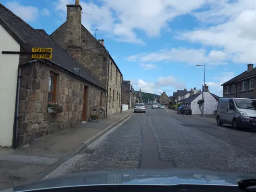
Rothes (; Scottish Gaelic: Ràthais) is a town in Moray, Scotland, on the banks of the River Spey, 10 miles (16 km) south of Elgin. The town had a population of 1,252 at the 2011 Census. A settlement has been here since AD 600.
From the Wikipedia article Rothes (this version), under CC BY-SA 4.0.
Things to do2

Craigellachie Bridge
Bridge · 2.5 mi
Cast-iron bridge in Moray, Scotland

The Linn
Waterfall · 2.7 mi
Waterfall on the Burn of Garbity in Moray, Scotland, UK
Museums and landmarks3

Parks, trails and playgrounds1

Restaurants and cafes6

The Glenrothes Distillery
Brewery and winery · 0.4 mi
Burnside Street, Rothes


History
At the south end of the village lie the remains of Rothes Castle (57.5252°N 3.2092°W / 57.5252; -3.2092 (Rothes Castle)), built on a hill by Peter de Pollok about 1200 to command traffic up and down this stretch of Strathspey. The castle's remains consist of a fragment of the massive outer wall overlooking the High Street of Rothes town. The castle was four storeys high, with a portcullis guarding the entrance to the inner courtyard and a drawbridge that crossed the dry moat, which ran between the outer wall and the hill on which the castle stood. Sir Norman Leslie, the castle's owner, was host to King Edward I of England on 29 July 1296.
In the 1390s Rothes Castle and its lands were passed to the Leslie family, who would later become the Earls of Rothes. Some of the earliest houses in Rothes were built from stones of the castle, which were taken by villagers to build dwellings after the castle was set alight and destroyed in 1662. The town can clearly be seen on maps even before this date. John Grant of Easter Elchies acquired the estate from John Hamilton-Leslie, 9th Earl of Rothes in 1711. John Grant of Easter Elchies sold his estate to James Ogilvy, 5th Earl of Findlater and 2nd Earl of Seafield shortly thereafter.
Read more of the history
An official notice by James Ogilvy, 5th Earl of Findlater and 2nd Earl of Seafield, of intention to feu a town on the Mains of Rothes was placed on 12 December 1763 to the Elginshire Council, and in 1766 the Seafields laid out plans for a crofting township to align north–south along the valley. This forms the genesis of most of the road patterns in Rothes today. The planned town formed a cross to replicate the Saltire in honour of St. Andrew. It overlay its old unplanned predecessor, which can still be seen on the ground. A formal let of 23 tenements by the earl were placed on 1 March 1790.
From the History section of Rothes on Wikipedia, under CC BY-SA 4.0.
More about Rothes
Economy
Rothes is home to four distilleries—Speyburn-Glenlivet Distillery, Glen Grant Distillery, Glen Spey Distillery and Glenrothes Distillery. Caperdonich distillery was the fifth in the town but was mothballed in 2002 and demolished in 2010.
Rothes's Glen Grant distillery opened its own bottling plant in 2013. The distillery forms part of the Scotland's Malt Whisky Trail.
The Helius CoRDe Biomass Plant was a joint venture by the Combination of Rothes Distillers Ltd and Helius Energy. It was officially opened by Charles, Duke of Rothesay, on 16 April 2013.
In addition to the distilleries, Forsyths is a major employer in the town. They specialize in fabrication for the oil and gas industry and the alcoholic-beverage industry.
From the Wikipedia article Rothes, under CC BY-SA 4.0.
Notable people from Rothes
- John SimpsonCanadian politician from Ontario (1812-1885)
Born in Rothes, according to Wikidata (CC0). Each name links to its Wikipedia article.
Where to stay2
Churches and places of worship1
Shopping1
Schools, colleges and libraries1
Map of Rothes
17 places. The map loads OpenStreetMap tiles when you open it.
Getting there and nearby towns
RAF Lossiemouth (LMO) is the nearest airport with scheduled flights listed in OpenStreetMap, 13 miles away.
- Charlestown of Aberlour 4 mi south, about 6 min by car
- Elgin 9 mi northwest, about 15 min by car
- Nairn 25 mi west, about 41 min by car
- Inverurie 35 mi southeast, about 56 min by car
- Inverness 38 mi west, about 1 h by car
- Westhill 43 mi southeast, about 1 h 15 min by car
- Ellon 44 mi east, about 1 h 15 min by car
- Fraserburgh 45 mi east, about 1 h 15 min by car
- Aberdeen 49 mi southeast, about 1 h 15 min by car
- Stonehaven 54 mi southeast, about 1 h 30 min by car
Drive times are estimates from straight-line distance, not routes.
Towns near Rothes


Keep exploring
Local news
Headlines from INDB.
Reviews, tips and questions
Loading what members have shared...
Sources and licences
- GeoNames (CC BY 4.0): population, coordinates, regions and time zone
- Mapillary (see each image): photos
- OpenStreetMap contributors (ODbL 1.0): places, airports, map data
- Wikidata (CC0 1.0): elevation, founding date, time zone, website, landmarks and historic places
- Wikimedia Commons (see each image): photos
- Wikipedia (CC BY-SA 4.0): overview and history text
Photo credits
- Rothes Glenrothes distillery letters, Ikiwaner, CC BY-SA 3.0
- Bridge in hill, Tama66, CC0
- GlenGrant2, S8z11, CC BY-SA 3.0
- 01-Glen-Grant, Dingerwarren, CC BY-SA 4.0
- Street-level photo, ccbb7766, CC BY-SA 4.0
- Street-level photo, hobgoblin, CC BY-SA 4.0
- Street-level photo, hobgoblin, CC BY-SA 4.0
- Street-level photo, hobgoblin, CC BY-SA 4.0
- Street-level photo, caz440, CC BY-SA 4.0
Page built November 10, 2026. Spotted a mistake? Tell us or suggest a place.