
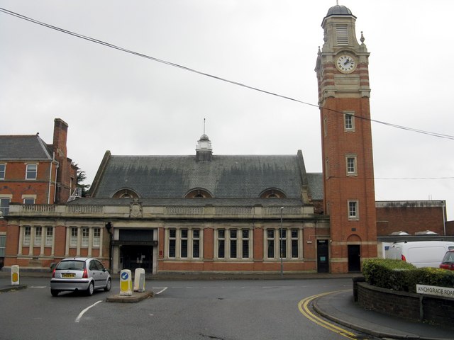


Sutton Coldfield, United Kingdom
Sutton Coldfield is a city of 109,899 people in England, United Kingdom.
Why visit Sutton Coldfield
Townapedia lists 14 museums and landmarks, 13 parks and trails, 99 places to eat, 4 places to stay and 2 attractions in and around town.
Highlights include Highbury Theatre Centre, Ashfurlong Hall, New Hall Mill and New Hall Valley Country Park.
Weather in Sutton Coldfield
Forecast from MET Norway (CC BY 4.0). Full forecast
About Sutton Coldfield
Sutton Coldfield is a town and civil parish in the city of Birmingham, West Midlands, England. The town lies around 7.5 miles northeast of Birmingham city centre, 11.5 miles south of Lichfield, 10.1 miles southwest of Tamworth, and 9.2 miles east of Walsall.
From the Wikipedia article Sutton Coldfield (this version), under CC BY-SA 4.0.
Photos of Sutton Coldfield


Things to do2

Highbury Theatre Centre
Cinema and theater · 2.1 mi
Theatre in Sutton Coldfield, Birmingham, England

Museums and landmarks14


Ashfurlong Hall
Monument and historic site · 1.2 mi
Tamworth Road, Sutton Coldfield
Vesey Manor
Monument and historic site · 0.8 mi
62, 64 Birmingham Road, Sutton Coldfield
Agnes Ann Bracken 1800-1877, Painter & Local Historian
Monument and historic site

2 more on the map.
Parks, trails and playgrounds13

New Hall Valley Country Park
Park · 1.2 mi
Country park in Birmingham, England


Plantsbrook Local Nature Reserve
Park · 2.8 mi
Park in Birmingham, United Kingdom

Short Heath Park
Park · 2.5 mi
Public park in Birmingham, United Kingdom


New Hall Hotel & Spa Pitch & Putt
Golf course · 1.3 mi
9 hole Pitch & Putt
Walmley Road, Sutton Coldfield


1 more on the map.
Restaurants and cafes99
Tikka Nation - Birmingham
Restaurant · Indian · 0.7 mi
Tikka Nation, an Indian restaurant & takeaway, serves authentic tikkas & curries at 14d Birmingham Rd, Sutton Coldfield B72 1QG, UK, +44...
14d Birmingham Road, Sutton Coldfield
Mo-Sa 11:00-22:00; Su 11:00-21:00

Caffè Nero
Cafe · Coffee Shop · 1.5 mi
Mulberry Walk, Sutton Coldfield
Mo-Fr 07:00-18:00; Sa 07:00-18:30; Su 08:30-18:00


Caffè Nero
Cafe · Coffee Shop · 0.5 mi
56 Parade, Sutton Coldfield
Mo-Fr 07:30-18:00; Sa 08:00-18:30; Su 09:00-17:30
The Station
Bar and pub
44 Station Street, Sutton Coldfield
Mo-Th 12:00-23:00; Fr-Sa 12:00-24:00; Su 12:00-22:30
White Horse
Bar and pub · 0.7 mi
116 Whitehouse Common Road, Sutton Coldfield
Mo-Th 11:00-23:00; Fr 11:00-22:30; Su 12:00-23:00
87 more on the map.
History
The etymology of the name Sutton appears to be from "South Town".
The name "Sutton Coldfield" appears to come from this time, being the "south town" (i.e. south of Tamworth and/or Lichfield) on the edge of the "col field". "Col" is usually derived from "charcoal", charcoal burners presumably being active in the area.
The earliest known signs of human presence in Sutton Coldfield were discovered in 2002–2003 on the boundaries of the town. Archaeological surveys undertaken in preparation for the construction of the M6 Toll road revealed evidence of Bronze Age burnt mounds near Langley Mill Farm, at Langley Brook. Additionally, evidence for a Bronze Age burial mound was discovered, one of only two in Birmingham with the other being located in Kingstanding. Excavations also uncovered the presence of an Iron Age settlement, dating to around 400 and 100 BC, consisting of circular houses built over at least three phases surrounded by ditches. Closer to Langley Brook (a tributary of the River Tame), excavations uncovered the remains of a single circular house surrounded by ditches, dating from the same period.
Read more of the history
Near to Langley Mill Farm is Fox Hollies, where archaeological surveys have uncovered flints dating from the New Stone Age. Amongst the finds in the area were flint cores and a flint scraper, which had been retouched with a knife. The presence of flint cores suggest that the site was used for tool manufacture and that a settlement was nearby. Additionally, a Bronze Age burnt mound was also discovered in the area.
In his History of Birmingham, published in 1782, William Hutton describes the presence of three mounds adjacent to Chester Road on the extremities of Sutton Coldfield (although now outside the modern boundaries of the town). The site, southwest of Bourne Pool (named "Bowen Pool" by Hutton), is called Loaches Banks and was mapped as early as 1752 by Dr. Wilks of Willenhall. Hutton interpreted the earthworks as a Saxon fortification but further archaeological work led Dr. Mike Hodder, now the Planning Archaeologist for Birmingham City Council, to believe that the site was an Iron Age hill-slope enclosure. Centuries of agriculture on the land has severely affected the visibility of the features, with the earthworks now only apparent in aerial photography.
Further evidence of pre-Roman human habitation are preserved in Sutton Park. A major fire in the park in 1926 revealed six more mounds near Streetly Lane, excavations of which uncovered charred and cracked stones within them and pits below the two largest mounds. Although their date of origin is unknown, claims they were of Bronze Age origin were disproved. The mounds are now covered in rough heathland. The area around Rowton's Well has been the source of many archaeological discoveries such as flint tools, and in the 18th century, worked timbers were discovered near the well, suggesting a possible Iron Age timber trackway built across wet land, similar to others discovered elsewhere in the country. A burnt mound was also discovered in New Hall Valley.
The presence of Romans in the area is most visible in Sutton Park, where a 1.5-mile (2.4 km) long preserved section of Icknield Street passes through. Whilst the road ultimately connects Gloucestershire to South Yorkshire, locally, the road was important for connecting Metchley Fort in Edgbaston with Letocetum, now Wall, in Staffordshire. The road is most visible from near to the pedestrian gate on Thornhill Road (OS Grid Reference SP 08759 98830), where the 8 m (26 ft) wide bank that formed the road surface is most prominent. Excavations at the road have showed that it was made from compacted gravel, never having a paved surface. Along each side are intermittent ditches, marked by Roman engineers, and beyond these are hollows where gravel was excavated to make the road surface. At least three Roman coins have been found along the course of Icknield Street through Sutton Park, as well as a Roman pottery kiln elsewhere in the town.
Next to the Iron Age property at Langley Brook, the remains of a timber building and field system were discovered. Pottery recovered from this site was dated to the second and third century, indicating the presence of a Roman farmstead.
Upon the Roman withdrawal from Britain to protect the Roman Empire on the continent in the fifth century, the area of Sutton Coldfield, still undeveloped, passed into the Anglo Saxon kingdom of Mercia. It is during this period that it is believed Sutton Coldfield may have originated as a hamlet, as a hunting lodge was built at Maney Hill for the purpose of the Mercian leaders. The outline of the deer park that it served is still visible within Sutton Park, with the ditch and bank boundary forming the western boundary of Holly Hurst, then crossing Keepers Valley, through the Lower Nuthurst and continuing on south of Blackroot Pool. Due to the marshy ground at Blackroot Valley, a fence was probably constructed to contain the deer, and the ditch and bank boundary commence again on the eastern side, on towards Holly Knoll.
This became known as Southun or Sutton; "ton" meaning the town stead to the south of Tamworth, the capital of Mercia. Middleton is situated between the two. "Coldfield" denotes an area of land on the side of hill that is exposed to the weather.
Sutone, as the manor became known, was held by Edwin, Earl of Mercia, during the reign of Edward the Confessor. Upon the death of Edwin in 1071, the manor and the rest of Mercia passed into the possession of the Crown, then ruled by William the Conqueror, resulting in Sutton Chase becoming a royal forest.
The manor of Sutone was mentioned in the Domesday Book of 1086, where it was rated at eight hides, making it larger than all surrounding villages in terms of cultivated land.
From the History section of Sutton Coldfield on Wikipedia, under CC BY-SA 4.0.
More about Sutton Coldfield
Geography
Sutton Coldfield borders the counties of Staffordshire and Warwickshire as well as the Metropolitan Borough of Sandwell, Metropolitan Borough of Solihull and Metropolitan Borough of Walsall. The town in general is regarded by its own populace as one of the most prestigious locations in the Birmingham area and even in Central England; a 2007 report by the website Mouseprice.com placed two Sutton Coldfield streets amongst the 20 most expensive in the United Kingdom.
The northern stretch of the Birmingham city sandstone ridge culminates at Sutton Coldfield. Plants Brook rises in the area of Streetly and flows through Sutton Park and directly beneath the town centre, then Plants Brook briefly flows through Erdington, notably Pype Hayes Park before returning to Sutton and culminating at Plantsbrook Nature Reserve on the Erdington / Walmley border at Eachelhurst Road.
Education
Fairfax Academy is on Reddicap Heath Road in the east of the town. Opposite the school is The Royal School which was formerly John Willmott School. Sutton Coldfield Grammar School for Girls is on Jockey Road (A453). Bishop Vesey's Grammar School, its male equivalent, is on Lichfield Road (A5127) and next to Sutton College which is part of Birmingham Metropolitan College. The Arthur Terry School is on Kittoe Road in Four Oaks, in the north of the town near Butlers Lane station. The Plantsbrook School (formerly The Riland Bedford School which was merged with Boldmere School in 1988) is on Upper Holland Road near the centre of the town in Maney. The Bishop Walsh Catholic School is next to the Sutton Park Line and New Hall Valley Country Park; the school is 10 minutes from Wylde Green and Walmley . All these schools are for ages 11–18. However, from September 1972 until July 1992, schools in the Sutton Coldfield area were divided into first school for pupils aged 5–8 years, middle schools for pupils aged 8–12 years, while the entry age for secondary school was set at 12 years.
There are also a number of primary schools located in the town including:
The Shrubbery School (established in 1930, is a private primary school located on the fringes of Walmley and Hollyfield primary located on Hollyfield Road, founded in 1907)
From the Wikipedia article Sutton Coldfield, under CC BY-SA 4.0.
Notable people from Sutton Coldfield
 Rob HalfordBritish heavy metal singerPhoto: Birgit Fostervold, CC BY-SA 4.0
 Scott AdkinsEnglish actor and martial artist (born 1976)Photo: Raboe001, CC BY-SA 3.0
 Rory DelapIrish association football playerPhoto: Wonker, CC BY 2.0
 Ken MilesBritish racing driver (1918–1966)Photo: Raycrosthwaite, CC BY-SA 3.0
 Paul ManningEnglish cyclistPhoto: Nicola, CC BY-SA 4.0
 Hazel CourtEnglish actress (1926–2008)Photo: [2], Public domain
 Oliver PhelpsBritish actorPhoto: Gage Skidmore, CC BY-SA 3.0
 Laura UnsworthBritish field hockey playerPhoto: fourthandfifteen, CC BY 2.0
 James PhelpsBritish actorPhoto: Gage Skidmore, CC BY-SA 3.0
- Cat DeeleyEnglish television presenter, actress, singer and model
- Dorian YatesSix-Times Mr. Olympia
- Carl IkemeNigerian footballer
Born in Sutton Coldfield, according to Wikidata (CC0). Each name links to its Wikipedia article.
Where to stay4
Churches and places of worship32
Four Oaks Methodist Church
Church · Methodist · 1.0 mi
Lichfield Road, Sutton Coldfield
St James Church, Hill
Church · Anglican · 1.5 mi
Mere Green Road, Sutton Coldfield
Shopping24
Gas and EV charging7
Schools, colleges and libraries23
St Joseph's Catholic Primary School
School · Roman Catholic · 0.5 mi
Little Sutton Lane, Sutton Coldfield
Healthcare8
Brutons Pharmacy
Clinic and pharmacy · 1.2 mi
7 Churchill Parade, Sutton Coldfield
Sutton Coldfield Cottage Hospital
Hospital · 0.7 mi
Birmingham Road, Sutton Coldfield
Map of Sutton Coldfield
226 places. The map loads OpenStreetMap tiles when you open it.
Getting there and nearby towns
Birmingham Airport (BHX) is the nearest airport with scheduled flights listed in OpenStreetMap, 8 miles away.
- Streetly 3 mi west, about 5 min by car
- Castle Vale 3 mi south, about 5 min by car
- Curdworth 4 mi southeast, about 7 min by car
- Aldridge 5 mi northwest, about 8 min by car
- Water Orton 5 mi southeast, about 8 min by car
- Birmingham 7 mi southwest, about 11 min by car
- Walsall 7 mi west, about 11 min by car
- West Bromwich 8 mi southwest, about 13 min by car
- Wolverhampton 13 mi west, about 21 min by car
- Worcester 31 mi southwest, about 50 min by car
Drive times are estimates from straight-line distance, not routes.
Towns near Sutton Coldfield


Keep exploring
Local news
Headlines from INDB.
Reviews, tips and questions
Loading what members have shared...
Sources and licences
- GeoNames (CC BY 4.0): population, coordinates, regions and time zone
- Mapillary (see each image): photos
- OpenStreetMap contributors (ODbL 1.0): places, airports, map data
- Wikidata (CC0 1.0): elevation, founding date, time zone, website, landmarks and historic places
- Wikimedia Commons (see each image): photos
- Wikipedia (CC BY-SA 4.0): overview and history text
Photo credits
- Sutton Coldfield Town Hall, Peter Whatley, CC BY-SA 2.0
- 14 High Street, Sutton Coldfield - sculpture (31671741833), Elliott Brown from Birmingham, United Kingdom, CC BY-SA 2.0
- Vesey Gardens - Sutton Coldfield - tablet - John Vesey - (1462 - 1554) (32360891451), Elliott Brown from Birmingham, United Kingdom, CC BY-SA 2.0
- Sutton Coldfield, UK - panoramio, Tanya Dedyukhina, CC BY 3.0
- Nicola Dixon Memorial - Trinity Hill, Sutton Coldfield (36293784691), Elliott Brown from Birmingham, United Kingdom, CC BY-SA 2.0
- New Hall Valley Country Park, Erebus555 at English Wikipedia, CC BY-SA 3.0
- Bleak Hill Park - 2011-01-29, Voice of Clam, Public domain
- Plantsbrook Nature Reserve (14 March 2007), Roy Shakespeare, CC BY-SA 2.0
- Short Heath Park - 2011-01-29, Voice of Clam, Public domain
- Sutton Park Walk 807 (N595), Ted and Jen, CC BY 2.0
- St John the Baptist Church, Middleton, Jimfbleak, CC BY-SA 3.0
- Erdington Abbey - 2011-01-29, Voice of Clam, Public domain
- St. Barnabas Church, Erdington - 2013-01-12, Voice of Clam, Public domain
- Holy Trinity Church, Sutton Coldfield2, Erebus555 at English Wikipedia, CC BY-SA 3.0
- Birmingham Metropolitan College James Watt Campus - 2010-06-27 - Andy Mabbett, Andy Mabbett, CC BY-SA 3.0
- Bishop-vesey-7, B72 Sutton Coldfield, CC BY-SA 2.0
- New Hall Manor Sutton Coldfield, Bs0u10e01, CC BY-SA 4.0
- St Chads Church, Sutton Coldfield, Erebus555, CC BY-SA 3.0
- Toby Carvery, Sutton Park - panoramio, fitzyt, CC BY 3.0
- Holy Trinity Methodist Church, Four Oaks. - panoramio, Tanya Dedyukhina, CC BY 3.0
- Matthew Boulton Campus 2010, Chemical Engineer, Public domain
- Arriva bus 2743 (LF02 PLU), 29 September 2012, Mikey from Wythenshawe, Manchester, UK, CC BY 2.0
- Sutton - panoramio, Tanya Dedyukhina, CC BY 3.0
- Nicola Dixon Memorial - Trinity Hill, Sutton Coldfield (36385051866), Elliott Brown from Birmingham, United Kingdom, CC BY-SA 2.0
- Street-level photo, adam2, CC BY-SA 4.0
- Street-level photo, southglos, CC BY-SA 4.0
- Street-level photo, adam2, CC BY-SA 4.0
- Street-level photo, southglos, CC BY-SA 4.0
- Street-level photo, adam2, CC BY-SA 4.0
- Street-level photo, southglos, CC BY-SA 4.0
- Street-level photo, southglos, CC BY-SA 4.0
- Street-level photo, southglos, CC BY-SA 4.0
- Street-level photo, adam2, CC BY-SA 4.0
- Street-level photo, southglos, CC BY-SA 4.0
- Street-level photo, adam2, CC BY-SA 4.0
- Street-level photo, southglos, CC BY-SA 4.0
- Street-level photo, southglos, CC BY-SA 4.0
- Street-level photo, adam2, CC BY-SA 4.0
- Street-level photo, southglos, CC BY-SA 4.0
- Street-level photo, southglos, CC BY-SA 4.0
- Street-level photo, southglos, CC BY-SA 4.0
- Street-level photo, southglos, CC BY-SA 4.0


Page built November 10, 2026. Spotted a mistake? Tell us or suggest a place.