
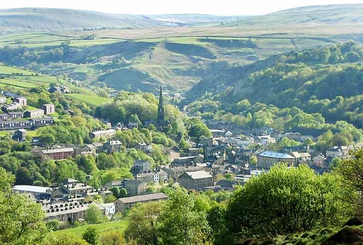


Todmorden, United Kingdom
Todmorden is a town of 11,690 people in England, United Kingdom.
Why visit Todmorden
Townapedia lists 18 museums and landmarks, 13 parks and trails, 60 places to eat, 2 places to stay and 1 attraction in and around town.
Highlights include Hippodrome Theatre, Dobroyd Castle and Todmorden War Memorial.
Weather in Todmorden
Forecast from MET Norway (CC BY 4.0). Full forecast
About Todmorden
Todmorden is a market town and civil parish in the Upper Calder Valley in Calderdale, West Yorkshire, England. It is 17 miles (27 kilometres) north-east of Manchester, 8 miles (13 km) south-east of Burnley and 9 miles (14 km) west of Halifax. In 2011, it had a population of 15,481.
From the Wikipedia article Todmorden (this version), under CC BY-SA 4.0.
Travel tips from other travellers: Todmorden on Wikivoyage (CC BY-SA 4.0).
Things to do1

Museums and landmarks18


Todmorden War Memorial
Monument and historic site · 0.5 mi
Statue in Todmorden, Calderdale, West Yorkshire, England, UK
Blackheath Circle
Monument and historic site · 0.9 mi
Originally thought to be a Roman Barrow but archeological digs found items from much earlier - this was originally a Bronze Age Ring...

6 more on the map.
Parks, trails and playgrounds13






1 more on the map.
Restaurants and cafes60

Golden Lion Inn
Bar and pub · Thai
Fielden Square, Todmorden
Mo-Th 15:00-00:00; Fr-Sa 13:00-01:00; Su 15:00-22:00

Pinch of Spice
Restaurant · Indian
26-32 Rochdale Road, Todmorden
Mo-Th 16:00-22:30; Fr,Sa 16:00-23:00; Su 14:00-22:00


The Beer Necessities
Bar and pub
17 Water Street, Todmorden
Tu 16:00-22:00; Su, We-Th 13:00-22:00; Fr-Sa 12:00-23:00
The Fox
Bar and pub
5-9 Water Street, Todmorden
Tu-We 12:00-21:00; Th 12:00-22:00; Fr-Sa 12:00-23:00; Su 12:00-21:00

Baked Artisan Bakery
Bakery · Pizza
2 Longfield Road, Todmorden
We-Sa 10:30-15:30; Su 11:30-15:30
The Boardroom
Cafe · Coffee Shop, Sandwich, Breakfast
10 Rochdale Road, Todmorden
Mo-Tu,Fr 09:30-16:30; We-Th off; Sa 09:30-16:00; Su 10:00-16:00
48 more on the map.
History
The name Todmorden is first attested in 1246, in the form Totmardene; other pre-modern spellings include Tottemerden, Totmereden and Totmerden. This is thought to originate in Old English as a personal name, Totta, combined with the Old English words mǣre ('border, boundary') and denu ('valley'). Thus the name once meant 'Totta's border-valley'. The valley in question is thought to have been the one running north-west from the town, and the border the one between Lancashire and Yorkshire.
Although, fanciful and historically implausible, alternative etymologies circulate, such as the speculation that the name derives from two words for death: German Tod and French mort, or that the name meant 'marshy den of the fox', supposedly from tod, a word of uncertain origin meaning 'fox' first attested around 1200, moor (which in Old English meant 'marsh'), and den (also attested in Old English to mean an animal's lair).
'Tod' is an informal name for Todmorden, often used in everyday conversation.
In 1898, Blackheath Barrow—a ring cairn monument situated above Cross Stone in Todmorden—was excavated and proved to be a site of "surpassing archaeological interest", according to J. Lawton Russell, one of the men who carried out the excavation. Various Bronze Age items were discovered, including sepulchral urns, a human skull, teeth and hands.
Read more of the history
Russell contended that Blackheath Barrow was primarily a religious site, specifically intended for the "performance of funeral rites", as there was no evidence that it had been settled for domestic use. Of particular interest were the four cairns, positioned at the cardinal points of the compass, and it has been suggested that this indicates "a ritual evocation of the airts, or spirits of the four directions, with obvious correlates in relation to spirits in the land of the dead".
The various finds from the 1898 dig are now housed in the Todmorden Library, on permanent display.
Settlement in medieval Todmorden was dispersed, most people living in scattered farms or in isolated hilltop agricultural settlements. Packhorse trails were marked by ancient stones, of which many still survive.
For hundreds of years, streams from the surrounding hills provided water for corn and fulling mills. Todmorden grew to relative prosperity by combining farming with the production of woollen textiles. Some yeomen clothiers were able to build fine houses, a few of which still exist today. Increasingly, though, the area's industry turned to cotton. The proximity of Manchester, as a source of material and trade, was undoubtedly a strong factor. Another was that the strong Pennine streams and rivers were able to power the machine looms. Improvements in textile machinery (by John Kay, James Hargreaves and Richard Arkwright), along with the development of turnpike roads (1751–1781), helped to develop the new cotton industry and to increase the local population.
In 1801, most people still lived in the uplands; Todmorden itself could be considered as a mere village. During the years 1800–1845, great changes took place in the communications and transport of the town which were to have a crucial effect on promoting industrial growth. These included the building of: (1) better roads; (2) the Rochdale Canal (1804); and (3) the main line of the Manchester and Leeds Railway (1841), which became the Lancashire and Yorkshire Railway in 1847. This railway line incorporated the (then) longest tunnel in the world, the 2,885-yard-long (2,638-metre) Summit Tunnel. A second railway, from Todmorden to Burnley, opened as a single line in 1849, being doubled to meet demand in 1860. A short connecting line, from Stansfield Hall to Hall Royd, completed the "Todmorden Triangle" in 1862, thus enabling trains to travel in all three directions (Manchester, Leeds and Burnley) without reversing.
The Industrial Revolution caused a concentration of industry and settlement along the valley floor and a switch from woollens to cotton. One family in the area was particularly influential on the town; the Fielden family. They created a "dynasty" that changed the town forever by establishing several large mills, putting up assorted impressive buildings and bringing about social and educational change.
A double murder took place at Christ Church, Todmorden on 2 March 1868. The victims' graves lie in the churchyard. Miles Weatherhill, a 23-year-old weaver from the town, was forbidden from seeing his housemaid sweetheart, Sarah Bell, by the Reverend Anthony John Plow. Armed with four pistols and an axe, Weatherhill took revenge first on the vicar and then on Jane Smith, another maid who had informed Plow of the secret meetings. Miss Smith died at the scene, while the vicar survived another week before succumbing to his injuries. Weatherhill also seriously injured the vicar's wife. On 4 April 1868, Weatherhill became the last person to be publicly hanged in Manchester, at the New Bailey prison. Local legend has it that the face of a young woman is sometimes seen in the window of the vicarage, now in private ownership.
Throughout the first decade of the 20th century, the population of the Borough of Todmorden remained constant. The ten-yearly UK census returns show figures of 25,418 in 1901 and 25,404 in 1911. Like the rest of the Upper Calder Valley, Todmorden's economy experienced a slow decline from around the end of World War I onwards, accelerating after World War II until around the late 1970s. During this period there was a painful restructuring of the local economy with the closure of mills and the demise of heavy industry.
From the History section of Todmorden on Wikipedia, under CC BY-SA 4.0.
More about Todmorden
Geography
Other villages and towns in the Upper Calder Valley include Hebden Bridge and Mytholmroyd. The territory of the civil parish of Todmorden also extends to cover Eastwood, Walsden, Cornholme, Mankinholes, Lumbutts, Robinwood, Lydgate, Portsmouth, Shade, Stansfield, Dobroyd, Ferney Lee, Gauxholme and Cross Stone.
Medieval Todmorden had consisted of the townships of Langfield and Stansfield in Yorkshire, and Todmorden/Walsden section of the greater township of Hundersfield in the Ancient Parish of Rochdale, Lancashire. The township of Todmorden and Walsden was created in 1801 by the union of the older villages of Todmorden and Walsden.
Economy
Heavy industry is now part of Todmorden's history, not its present. The industrial chimneys have largely gone and the remaining mills have mostly been converted for other purposes. The town's industrial base is much reduced (at one time Todmorden had the largest weaving shed in the world). Todmorden also services the local rural area and attracts visitors through its market (indoor and outdoor), various events, heritage and the local Pennine countryside. It has for centuries been considered the safest accessible route directly across the Pennines.
Arts and culture
Local TV coverage is provided by BBC Yorkshire and ITV Yorkshire. Until 2009, local television was provided by BBC North West and ITV Granada. Radio stations that broadcast to Todmorden are BBC Radio Leeds, Capital Yorkshire, Heart Yorkshire and Greatest Hits Radio West Yorkshire.
Todmorden's local newspaper is the Todmorden News owned by Johnston Press, now merged (since October 2015) with the Hebden Bridge Times from the neighbouring town by the same publisher. Singletrack, a national mountain biking magazine, is based in Todmorden.
Todmorden has been used as a location for the 1980s BBC TV police drama Juliet Bravo, Territorial Army series All Quiet on the Preston Front, parts of The League of Gentlemen, BBC TV miniseries Oranges Are Not the Only Fruit, the BBC1 series Life on Mars, a town in the book Spooks Blood and a film adaptation of the novel My Summer of Love. The BBC One crime drama series Happy Valley, written by Sally Wainwright (who grew up in nearby Sowerby Bridge), is filmed in and around the town, amongst other locations. In the 1980s, the town was used for two consecutive episodes of BBC fashion series The Clothes Show.
From the Wikipedia article Todmorden, under CC BY-SA 4.0.
Notable people from Todmorden
 Keith EmersonBritish recording artist; keyboard player and composer (1944–2016)Photo: Unknown author Unknown author, Public domain
 John HelliwellBritish musicianPhoto: Tilly antoine, CC BY-SA 4.0
 Samuel FieldenAmerican anarchist (1847–1922)Photo: Samuel_Fielden_portrait.jpg..., Public domain
 John RamsbottomBritish railway engineerPhoto: William Percy (Life time: 1820–1893), Public domain
- John CockcroftBritish physicist (1897–1967)
- Geoffrey WilkinsonBritish Nobel laureate in Chemistry
- Grenville TurnerBritish geochemist (1936–2024)
- Rebecca TaylorEnglish politician (born 1975)
- John Mitchell NuttallBritish physicist (1890–1958)
- Peter LeverEnglish Test and County cricketer
- Peter GreenwoodEnglish footballer and cricketer (1924–2021)
- Haughton Ackroydfootball player (1894-1979)
Born in Todmorden, according to Wikidata (CC0). Each name links to its Wikipedia article.
Where to stay2
Churches and places of worship11
Kingdom Hall of Jehovah's Witnesses
Church · Jehovahs Witness
Stansfield Road, Todmorden
Shopping14
Gas and EV charging2
Schools, colleges and libraries11
Healthcare2
Map of Todmorden
134 places. The map loads OpenStreetMap tiles when you open it.
Getting there and nearby towns
Leeds Bradford Airport (LBA) is the nearest airport with scheduled flights listed in OpenStreetMap, 21 miles away.
- Burnley 8 mi northwest, about 13 min by car
- Oldham 12 mi south, about 19 min by car
- Huddersfield 14 mi east, about 22 min by car
- Whitefield 14 mi southwest, about 23 min by car
- Bradford 15 mi east, about 24 min by car
- Blackburn 16 mi west, about 26 min by car
- Bolton 16 mi southwest, about 27 min by car
- Manchester 17 mi south, about 28 min by car
- Salford 18 mi southwest, about 28 min by car
- Stockport 21 mi south, about 34 min by car
Drive times are estimates from straight-line distance, not routes.
Towns near Todmorden


Keep exploring
Local news
Headlines from INDB.
Reviews, tips and questions
Loading what members have shared...
Sources and licences
- GeoNames (CC BY 4.0): population, coordinates, regions and time zone
- OpenStreetMap contributors (ODbL 1.0): places, airports, map data
- Wikidata (CC0 1.0): elevation, founding date, time zone, website, landmarks and historic places
- Wikimedia Commons (see each image): photos
- Wikipedia (CC BY-SA 4.0): overview and history text
Photo credits
- Tod from golf course, Loh93 at English Wikipedia, Public domain
- West Yorkshire PTE bus 3302 in Todmorden Bus Station, West Yorkshire 28 June 1986, Dr Neil Clifton, CC BY-SA 2.0
- Benchmark at Todmorden Market Hall, Ray Hutchings, CC BY-SA 4.0
- Dobroydcourtyard, Dvprknsn at English Wikipedia, CC BY-SA 3.0
- Golden Lion, Todmorden (4781020616), Tim Green from Bradford, UK, CC BY 2.0
- St Peter, Walsden 1 (4435572625), Tim Green from Bradford, CC BY 2.0
- Unitarian Church, Todmorden (2517085652), Tim Green from Bradford, CC BY 2.0
- Statue of John Fielden, Centre Vale Park, Todmorden (8106051941), Tim Green from Bradford, CC BY 2.0

Page built November 10, 2026. Spotted a mistake? Tell us or suggest a place.