


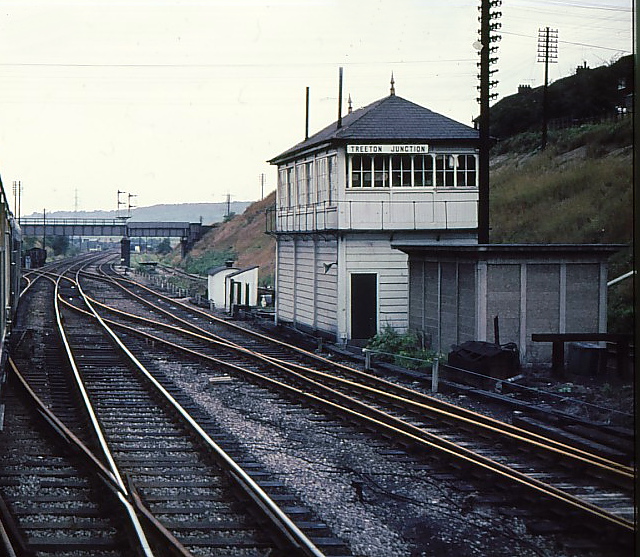


Why visit Treeton
Townapedia lists 3 museums and landmarks, 7 parks and trails, 27 places to eat, 2 places to stay and 3 attractions in and around town.
Highlights include Rotherham Bridge, Tinsley Viaduct, Clifton Park Museum and Catcliffe Glass Cone.
Weather in Treeton
Forecast from MET Norway (CC BY 4.0). Full forecast
About Treeton
Treeton is a village and civil parish of the Metropolitan Borough of Rotherham in South Yorkshire, England. It is located about 4 miles (6 km) south of the town of Rotherham and 5 miles (8 km) east of Sheffield City Centre.
From the Wikipedia article Treeton (this version), under CC BY-SA 4.0.
Things to do3

Rotherham Bridge
Bridge · 3.3 mi
Grade I listed bridge in Rotherham, South Yorkshire, England


Museums and landmarks3

Clifton Park Museum
Museum · 3.0 mi
Municipal museum situated in Clifton House on the western edge of Clifton Park in Rotherham, South Yorkshire, England

Catcliffe Glass Cone
Monument and historic site · 0.6 mi
Main Street, Rotherham

Parks, trails and playgrounds7

Blackburn Meadows
Park · 3.2 mi
Area of land inside the Sheffield city at Tinsley


Restaurants and cafes27

Yorkshire Terrier
Bar and pub · 1.2 mi
Whitehill Road, Rotherham
Mo-Th,Su 12:00-23:30; Fr,Sa 12:00-00:30


Serve
Cafe · 1.0 mi
Mo-We 07:00-19:00; Th-Fr 07:00-23:00; Sa 08:00-23:00; Su 08:00-21:00
15 more on the map.
History
There is evidence of Mesolithic and Neolithic settlement in this area. In 1954 a Neolithic polished stone axe was found at Gregory Hill Field, and in 1957 Mesolithic flint cores were found in Treeton Wood. There was a Roman fort at Templeborough, about 2.8 miles (4.5 km) north west of Treeton, and remnants of the Roman road called Icknield Street (sometimes Ryknild or Riknild Street) have been found in nearby Brinsworth.
The name Treeton is Old English in origin and may mean 'tree farmstead' or 'farmstead built with posts'. The earliest known written record of Treeton is the Domesday Book of 1086, in which it is referred to as Trectone or Tretone. The Domesday Book also mentions that the village had two mills and a church. The present parish church the Church of St Helen was originally built in the 12th century, but may have included parts of an earlier church. The church was expanded in the 14th century and extensively restored in the 19th century.
The North Midland Railway built a railway through the village in 1840, this later became the Midland Railway. There was a station at Treeton until 1951. A colliery was built at Treeton starting in 1875, and 400 houses were built between 1881 and 1905 to house miners' families. Treeton Colliery closed in 1990 and the site has since been redeveloped for homes.
From the History section of Treeton on Wikipedia, under CC BY-SA 4.0.
More about Treeton
Geography
Treeton is situated on the east side of the River Rother, about 4 miles (6 km) south from the town of Rotherham and 5 miles (8 km) east from Sheffield City Centre. The village sits on the slopes of the Rother Valley, ranging from about 130 feet (40 m) to 260 feet (80 m) above mean sea level. The lower section of the village is susceptible to flooding and had to be evacuated during the floods of June 2007 because of fears that cracks in the dam at Ulley reservoir could lead to widespread flooding in the valley.
From the Wikipedia article Treeton, under CC BY-SA 4.0.
Notable people from Treeton
- Jesse PyeEnglish footballer (1919-1984)
- Albert CoxEnglish footballer (1917-2003)
- Horace Copeassociation football player (1899-1961)
- Peter PerryEnglish footballer (1936-2011)
- George ThompsonEnglish footballer, born 1900
- John Parkin TaylorNew Zealand politician (1812–1875)
Born in Treeton, according to Wikidata (CC0). Each name links to its Wikipedia article.
Where to stay2
Churches and places of worship13
Shopping2
Gas and EV charging5
Schools, colleges and libraries8
Healthcare1
Map of Treeton
71 places. The map loads OpenStreetMap tiles when you open it.
Getting there and nearby towns
Nottingham City Airport (NQT) is the nearest airport with scheduled flights listed in OpenStreetMap, 34 miles away.
- Catcliffe 1 mi northwest, about 1 min by car
- Rotherham 3 mi north, about 5 min by car
- Beighton 4 mi south, about 6 min by car
- Burngreave 4 mi west, about 7 min by car
- Sheffield 5 mi west, about 8 min by car
- Rawmarsh 5 mi north, about 8 min by car
- Todwick 5 mi southeast, about 7 min by car
- Hellaby 5 mi northeast, about 8 min by car
- Dinnington 6 mi east, about 10 min by car
- Maltby 7 mi east, about 11 min by car
Drive times are estimates from straight-line distance, not routes.
Towns near Treeton


Keep exploring
Local news
Headlines from INDB.
Reviews, tips and questions
Loading what members have shared...
Sources and licences
- GeoNames (CC BY 4.0): population, coordinates, regions and time zone
- Mapillary (see each image): photos
- OpenStreetMap contributors (ODbL 1.0): places, airports, map data
- Wikidata (CC0 1.0): elevation, founding date, time zone, website, landmarks and historic places
- Wikimedia Commons (see each image): photos
- Wikipedia (CC BY-SA 4.0): overview and history text
Photo credits
- Treeton Terrace, Michael Patterson, CC BY-SA 2.0
- St Helen's Church, Treeton, Chris Morgan, CC BY-SA 2.0
- Treeton Jct Signalbox, Phil Sangwell from United Kingdom, CC BY 2.0
- Clifton House March 2017, Chemical Engineer, CC BY-SA 4.0
- Rotherham Minster, Warofdreams, CC BY-SA 4.0
- Attercliffe Chapel, Warofdreams, CC BY-SA 4.0
- St Catherine of Siena, Richmond, Warofdreams, CC BY-SA 4.0
- St Marys Church Handsworth Sheffield, Wikityke, CC BY-SA 1.0
- Treeton St Helen 2006-02-03, Michael Patterson, CC BY-SA 2.0
- CatcliffeGlassCone, Webmaster, CC BY-SA 2.0
- Main school entrance 2014-02-15 13-49, User:Burrowspaul, CC BY-SA 3.0
- Rotherham - Bridge Street Bridge over Don Navigation, Dave Bevis, CC BY-SA 2.0
- Tinsley viaduct at sunset, Liz Jones from Sheffield, UK, CC BY 2.0
- Brinsworth - Yorkshire Terrier, Michael Patterson, CC BY-SA 2.0
- Street-level photo, skifans, CC BY-SA 4.0
- Street-level photo, sk53, CC BY-SA 4.0
- Street-level photo, sk53, CC BY-SA 4.0
- Street-level photo, skifans, CC BY-SA 4.0
- Street-level photo, edloach, CC BY-SA 4.0
- Street-level photo, skifans, CC BY-SA 4.0
- Street-level photo, sk53, CC BY-SA 4.0


Page built November 10, 2026. Spotted a mistake? Tell us or suggest a place.