
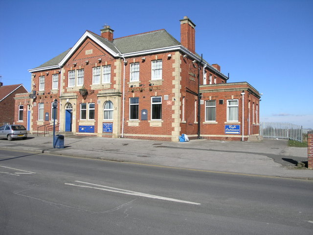


Dinnington, United Kingdom
Dinnington is a town of 19,860 people in England, United Kingdom.
Why visit Dinnington
Townapedia lists 6 parks and trails, 28 places to eat and 2 attractions in and around town.
Highlights include Tropical Butterfly House.
Weather in Dinnington
Forecast from MET Norway (CC BY 4.0). Full forecast
About Dinnington
Dinnington is a town in the civil parish of Dinnington St John's, in the Metropolitan Borough of Rotherham, in South Yorkshire, England. It is near to the towns of Worksop and Rotherham and cities of Sheffield and Doncaster.
From the Wikipedia article Dinnington, South Yorkshire (this version), under CC BY-SA 4.0.
Things to do2

Tropical Butterfly House
Zoo and aquarium · 0.8 mi
Woodsetts Road, Sheffield
Mo-Fr 10:00-16:00; Sa,Su 10:00-17:00; PH 10:00-17:00

Parks, trails and playgrounds6

Restaurants and cafes28





16 more on the map.
Churches and places of worship12

St Peter's Church, Letwell
Church · 1.8 mi
Church in Letwell, Rotherham, South Yorkshire, England, UK

Church of St James
Church · 1.6 mi
Grade I listed church in South Anston, South Yorkshire, England, UK
St John's Church, Throapham
Church · 1.2 mi
Grade I listed church in Throapham, South Yorkshire, England, UK
St Luke's Church, Shireoaks
Church · 3.3 mi
Church in Shireoaks, Bassetlaw, Nottinghamshire, England, UK

History
Excavations show Dinnington to have been inhabited since at least Neolithic times, and it has been suggested that the settlement takes its name from a local barrow, though a more traditional interpretation of "Dinnington" would be "Dunn's Farmstead", or "Town of Dunn's People".
Dinnington was originally a small, isolated farming community, based around the New Road area of the town. Quarrying in the area helped expand the population, but it was the sinking of the Dinnington Main Colliery in 1905 that led to the real growth of the settlement. The census of 1911 shows a twenty-fold increase in population of the parish since 1901, from 250 to 5,000. In 1951 the parish had a population of 7,053.
The coal miners initially lived in a prefabricated shanty town in Laughton Common, colloquially known as "Tin Town" or "White City" but later moved into colliery-built terrace houses around the central shopping area of Laughton Road.
Dinnington was an ancient parish which became a civil parish in 1866. On 1 April 1954 the civil parish was abolished and merged with the civil parish of St Johns with Throapham, to form the civil parish of Dinnington St John's.
Read more of the history
Dinnington continued to expand throughout the 20th century, largely through the growth of commuter living that followed the Second World War. As the housing estates spread, Dinnington began to merge seamlessly into the neighbouring settlements of Throapham and North Anston. The result is a 2.2 miles (3.5 km) strip of urban development that mainly acts as a commuter base for Sheffield, Rotherham and Worksop, although with the closure of coal mines and steel mills, the area saw a rapid decline in the late 1980s and early 1990s and despite steady growth, still boasted the highest level of unemployment in the UK in 2001.
Dinnington Colliery was closed in 1992. This damaged the local community, and had a large negative impact on the local economy with initial job losses and knock-on effect closures to local business. In 2019 Conservative Alexander Stafford was voted as the MP for the Rother Valley constituency, of which Dinnington is a part, many in Dinnington were understandably unhappy given the towns history with Conservative party. In 2023 Councillor Charlie Wooding was removed from his position after it was revealed that he had failed to attend council meeting while continuing to claim his wages, causing outrage in the town, a by-election was triggered and local resident Julia Hall was elected to take his place
In 1995, Dinnington was featured in an episode of the BBC1 TV documentary series Everyman, entitled Simon's Cross. The programme described the life of Dinnington parish priest, the Rev Simon Bailey, detailing his life, work and reflections while living with AIDS, and the way members of the parish of Dinnington came to terms with it and supported him. Scarlet Ribbons: A Priest with AIDS, an account of his story, was written by Simon Bailey's sister, Rosemary Bailey and published by Serpent's Tail in 1997. In 2003, Dinnington was declared a town as part of an attempt to attract more investment and improve the local economy.
Controversy arose in the village over plans to redevelop the Miners' Welfare. The Welfare buildings and sports fields were provided originally for the miners at the local colliery by CISWO in 1926. The property had been leased to Rotherham Borough Council and was used for Safe@Start programmes up until 2007. It has remained empty since that date and has been subject to vandalism and lack of repairs. Controversy over development resulted in the formation of a local residents' group opposing the development plans and asking for the regeneration of the site as an amenity for local people.
Dinnington had a population of 9,077 in the 2011 census, which makes it slightly larger than Wath-upon-Dearne. Here are the three areas known as Dinnington:
Built up area (contains Dinnington, Anston and Throapham) population 20,152
From the History section of Dinnington, South Yorkshire on Wikipedia, under CC BY-SA 4.0.
Notable people from Dinnington
 Ben TomlinsonBritish footballerPhoto: Bluewheel, CC BY-SA 2.0
- Dick Neal, Jr.English footballer (1933–2013)
- Norman CurtisFootballer (1924-2009)
- Tom Atterassociation football player (1901-1958)
- Paul MarshallEnglish cricketer (born 1949)
- David JohnsonEnglish former professional footballer (1940-)
- Jack Thorogoodfootballer (1911-1970)
- Ernie Marshallassociation football player (1918-1983)
Born in Dinnington, according to Wikidata (CC0). Each name links to its Wikipedia article.
Shopping9
Gas and EV charging3
Schools, colleges and libraries8
Map of Dinnington
68 places. The map loads OpenStreetMap tiles when you open it.
Getting there and nearby towns
Nottingham City Airport (NQT) is the nearest airport with scheduled flights listed in OpenStreetMap, 31 miles away.
- Maltby 3 mi north, about 6 min by car
- Rotherham 8 mi northwest, about 13 min by car
- Rawmarsh 9 mi northwest, about 14 min by car
- Staveley 9 mi southwest, about 15 min by car
- Mexborough 10 mi northwest, about 15 min by car
- Sheffield 11 mi west, about 18 min by car
- Doncaster 11 mi north, about 18 min by car
- Retford 11 mi east, about 18 min by car
- Wath upon Dearne 11 mi northwest, about 18 min by car
- Chesterfield 12 mi southwest, about 19 min by car
Drive times are estimates from straight-line distance, not routes.
Towns near Dinnington


Keep exploring
Local news
Headlines from INDB.
Reviews, tips and questions
Loading what members have shared...
Sources and licences
- GeoNames (CC BY 4.0): population, coordinates, regions and time zone
- Mapillary (see each image): photos
- OpenStreetMap contributors (ODbL 1.0): places, airports, map data
- Wikidata (CC0 1.0): elevation, founding date, time zone, website, landmarks and historic places
- Wikimedia Commons (see each image): photos
- Wikipedia (CC BY-SA 4.0): overview and history text
Photo credits
- Dinnington Saint John's - Lordens Hotel, Michael Patterson, CC BY-SA 2.0
- Dinnington Cross, Neil Theasby, CC BY-SA 2.0
- Letwell - Saint Peter's Church, Steve Fareham, CC BY-SA 2.0
- Street-level photo, kieran, CC BY-SA 4.0
Page built November 10, 2026. Spotted a mistake? Tell us or suggest a place.