


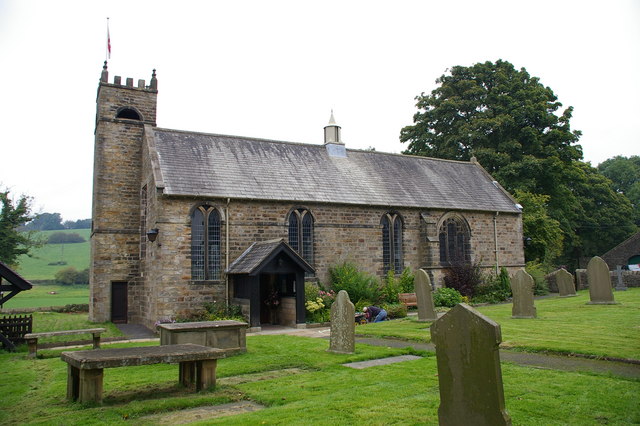

Waddington, United Kingdom
Waddington is a town of 1,028 people in England, United Kingdom.
Why visit Waddington
Townapedia lists 5 museums and landmarks, 3 parks and trails, 40 places to eat, 3 places to stay and 2 attractions in and around town.
Highlights include Edisford Bridge, The Grand, Clitheroe Castle and Clitheroe Castle Museum.
Weather in Waddington
Forecast from MET Norway (CC BY 4.0). Full forecast
About Waddington
Waddington is a small village, 2 miles (3 km) north-west of Clitheroe in the Ribble Valley, Lancashire, England. The population of the civil parish at the 2011 census was 1,028. Waddington lies just within the Bowland Rural District of the historic West Riding of Yorkshire. It covers approximately 2000 acres of the Forest of Bowland.
From the Wikipedia article Waddington, Lancashire (this version), under CC BY-SA 4.0.
Things to do2


Museums and landmarks5


Clitheroe Castle Museum
Museum · 1.6 mi
Museum in Lancashire, England, United Kingdom

Stock Well
Monument and historic site · 1.5 mi
“The smallest of the three borough wells used until water was supplied in 1856. It is first recorded in 1645. The well was sealed in...

St Mary’s Well
Monument and historic site · 1.5 mi
The name ‘St Mary’s suggests this was a Holy Well, and it possibly dates from medieval times. It is at the top of Well Terrace. There...
Parks, trails and playgrounds3


Restaurants and cafes40




28 more on the map.
History
Waddington was a mesne manor of the ancient Lordship of Bowland which comprised a Royal Forest and a Liberty of ten manors. These spanned eight townships and four parishes, covering an area of almost 300 square miles (780 km2) on the historic borders of Lancashire and Yorkshire. The manors within the Liberty were Slaidburn (Newton-in-Bowland, West Bradford, Grindleton), Knowlmere, Waddington, Easington, Bashall Eaves, Mitton, Withgill (Crook), Leagram, Hammerton and Dunnow (Battersby).
The Tempests were lords of the manor of Waddington from at least the early thirteenth century. The family is credited with endowing the parish church at Waddington. One of their number, Sir Nicholas Tempest, a Bowbearer of the Forest of Bowland, was hanged, drawn and quartered at Tyburn in 1537 for his part in the Pilgrimage of Grace.
Following his defeat in the Battle of Hexham during the Wars of the Roses on 15 May 1464, King Henry VI was sheltered by Lancastrian supporters at houses across the north of England. Following stays at Muncaster Castle on the Cumbrian coast and at nearby Bolton Hall, he went into hiding at Waddington Hall, the home of Sir Richard Tempest. He was betrayed by "a black monk of Addington" and on 13 July 1465, a group of Yorkist men, including Sir Richard's brother John, entered the home to arrest him. Henry fled into nearby woods but was soon captured.
Read more of the history
Waddington almshouses were endowed by Robert Parker of Browsholme Hall in 1700. St Helen's Church, which was rebuilt in 1825, has monuments to the Parker family.
From the History section of Waddington, Lancashire on Wikipedia, under CC BY-SA 4.0.
Where to stay3
Churches and places of worship12
Shopping9
Gas and EV charging1
Schools, colleges and libraries6
Waddington and West Bradford Church of England Voluntary Aided Primary School
School · Anglican · 0.4 mi
West Bradford Road, Clitheroe
Healthcare4
Clitheroe Health Centre
Clinic and pharmacy · 1.4 mi
Railway View Avenue, Clitheroe
Map of Waddington
85 places. The map loads OpenStreetMap tiles when you open it.
Getting there and nearby towns
Warton Aerodrome (WRT) is the nearest airport with scheduled flights listed in OpenStreetMap, 22 miles away.
- Clitheroe 2 mi south, about 3 min by car
- Great Harwood 7 mi south, about 12 min by car
- Padiham 7 mi southeast, about 12 min by car
- Brierfield 9 mi southeast, about 14 min by car
- Barnoldswick 9 mi east, about 15 min by car
- Burnley 10 mi southeast, about 16 min by car
- Blackburn 10 mi south, about 16 min by car
- Accrington 10 mi south, about 16 min by car
- Nelson 10 mi southeast, about 15 min by car
- Colne 10 mi east, about 17 min by car
Drive times are estimates from straight-line distance, not routes.
Towns near Waddington


Keep exploring
Local news
Headlines from INDB.
Reviews, tips and questions
Loading what members have shared...
Sources and licences
- GeoNames (CC BY 4.0): population, coordinates, regions and time zone
- OpenStreetMap contributors (ODbL 1.0): places, airports, map data
- Wikidata (CC0 1.0): elevation, founding date, time zone, website, landmarks and historic places
- Wikimedia Commons (see each image): photos
- Wikipedia (CC BY-SA 4.0): overview and history text
Photo credits
- Pivot at Waddington, Saint Helens Church, Ray Hutchings, CC BY-SA 4.0
- Bolt at Waddington, Saint Helens Church, Ray Hutchings, CC BY-SA 4.0
- Clitheroe Castle, Lux01 at English Wikipedia, Public domain
- Clitheroe Castle Museum, Gpwitteveen, CC BY-SA 3.0
- St Ambrose's Church, Grindleton, Alexander P Kapp, CC BY-SA 2.0
- Clitheroe Library 02, Immanuel Giel, CC BY-SA 4.0
- Stock Well plaque, Clitheroe, DIaNyf8q, CC0
Page built November 10, 2026. Spotted a mistake? Tell us or suggest a place.