


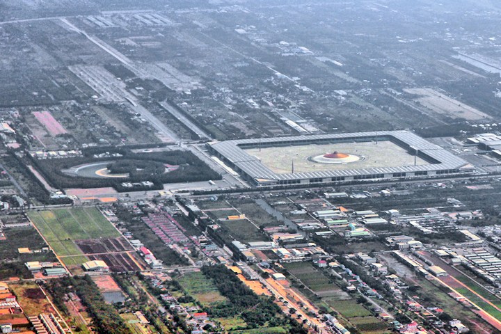

Khlong Luang, Thailand
เทศบาลเมืองคลองหลวง
Khlong Luang is a city of 118,551 people in Pathum Thani, Thailand.
Why visit Khlong Luang
Townapedia lists 1 museum or landmark, 11 places to eat and 1 attraction in and around town.
Highlights include Dhammakaya Foundation and Southeast Asian Ceramics Museum.
Weather in Khlong Luang
Forecast from MET Norway (CC BY 4.0). Full forecast
Photos of Khlong Luang


Things to do1

Museums and landmarks1

Southeast Asian Ceramics Museum
Museum · 4.3 km
History museum at Bangkok University, Pathum Thani, Thailand, displaying Southeast Asian ceramics
Restaurants and cafes11

REEKARR'S VEGAN
Cafe · Coffee Shop, Healthy Drinking · 1.4 km
18/176 ม.6 khongsam 6/5, คลองสาม คลองหลวง ปทุมธานี
Mo-Fr 09:00-15:00
The Baranee Club
Cafe · Coffee Shop · 2.2 km
111 ถนนเลียบคลองสาม
Mo-Su 08:00-17:00

Carnivore
Restaurant · Seafood, Korean · 1.5 km
41/134 คลองหลวงเมืองใหม่, ปทุมธานี
Mo-Su 16:00-22:00
Cafe in June
Cafe · Coffee Shop, Asian, Thai, Italian · 1.5 km
41/134 คลองหลวงเมืองใหม่, ปทุมธานี

Churches and places of worship7

Dhammakaya Temple
Place of worship · 1.2 km
International reception department is at level 2 of 100Years building.
2fl. of 100Years building, ปทุมธานี
Main Chapel of Dhammakaya Temple
Place of worship · 1.7 km
23/2 ม.7 คลองสาม, ปทุมธานี
Shopping6
Gas and EV charging3
Schools, colleges and libraries7
Healthcare2
Map of Khlong Luang
38 places. The map loads OpenStreetMap tiles when you open it.
Getting there and nearby towns
Don Mueang International Airport (DMK) is the nearest airport with scheduled flights listed in OpenStreetMap, 17 km away.
- Pak Kret 23 km southwest, about 23 min by car
- Mueang Nonthaburi 27 km southwest, about 27 min by car
- Nong Chok 33 km southeast, about 33 min by car
- Bangkok 38 km southwest, about 38 min by car
- Taling Chan 38 km southwest, about 38 min by car
- Thon Buri 42 km southwest, about 42 min by car
- Phasi Charoen 45 km southwest, about 45 min by car
- Samut Prakan 52 km south, about 52 min by car
- Nong Khaem 51 km southwest, about 51 min by car
- Nakhon Pathom 70 km southwest, about 1 h 15 min by car
Drive times are estimates from straight-line distance, not routes.
Towns near Khlong Luang


Keep exploring
Local news
Headlines from INDB.
Reviews, tips and questions
Loading what members have shared...
Sources and licences
- GeoNames (CC BY 4.0): population, coordinates, regions and time zone
- Mapillary (see each image): photos
- OpenStreetMap contributors (ODbL 1.0): places, airports, map data
- Wikidata (CC0 1.0): elevation, founding date, time zone, website, landmarks and historic places
- Wikimedia Commons (see each image): photos
Photo credits
- Khlong Song, Khlong Luang District, Pathum Thani 12120, Thailand - panoramio (2), mohigan, CC BY-SA 3.0
- Khlong Song, Khlong Luang District, Pathum Thani 12120, Thailand - panoramio, mohigan, CC BY-SA 3.0
- Khlong Song, Khlong Luang District, Pathum Thani 12120, Thailand - panoramio (1), mohigan, CC BY-SA 3.0
- Asian Institute of Technology, Pathum Thani (2007), Media lib, CC BY-SA 4.0
- Bangkok Universit..Rangsit campus. - panoramio, ::::=UT=::::, CC BY-SA 3.0
- SIIT rangsitMainBuilding 2565, Thas Tayapongsak, CC BY-SA 4.0
- 001 Wat Phra Dhammakaya, Bangkok, Thailand, Marek Ślusarczyk ( Tupungato ) Photo portfolio, CC BY 3.0
- Dhammakaya cetiya night, Horsemilk, CC BY-SA 3.0
- Nano center front view, Aju researcher ( talk ), GFDL
- Dhammakaya Temple Pagoda, 咽頭べさ, CC BY-SA 4.0
- Untitled, Richard Harrison, CC BY 3.0
- Pha Thummakay - panoramio, naf632002, CC BY 3.0
- Street-level photo, ThailandCambodia, CC BY-SA 4.0
- Street-level photo, ThailandCambodia, CC BY-SA 4.0
- Street-level photo, ThailandCambodia, CC BY-SA 4.0
- Street-level photo, ThailandCambodia, CC BY-SA 4.0


Page built November 10, 2026. Spotted a mistake? Tell us or suggest a place.