


Why visit Haßfurt
Townapedia lists 44 museums and landmarks, 22 parks and trails, 84 places to eat, 14 places to stay and 7 attractions in and around town.
Highlights include Ehemaliges Maintor, Unterer Turm, Eissportstadion Haßfurt and Erlebnisbad Haßfurt.
Weather in Haßfurt
Forecast from MET Norway (CC BY 4.0). Full forecast
About Haßfurt
Haßfurt (German pronunciation: [ˈhasˌfʊʁt] ; English: Hassfurt) is a town in Bavaria, Germany, capital of the Haßberge district. It is situated on the river Main, 20 km east of Schweinfurt and 30 km northwest of Bamberg. In 1852, Ludwig's Western Railway reached the town and between 1892 and 1995, which also had a branch line to Hofheim. The 1867 Hassfurt Bridge, thought to be the first Cantilever bridge built, was also there.
From the Wikipedia article Haßfurt (this version), under CC BY-SA 4.0.
Things to do7





Museums and landmarks44

Ehemaliges Maintor
Monument and historic site · 0.7 km
Massiver dreigeschossiger Torturm mit Zwiebelhaube und Laterne
8 Stadtmauerweg, Haßfurt

Unterer Turm
Monument and historic site · 1.0 km
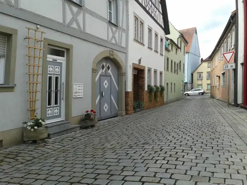
Würzburger Tor, quadratischer Torturm der Stadtbefestigung mit Pyramidendach, gewölbter Durchfahrt und Fußgängerdurchgang, Eckquaderungen
86 Hauptstraße, Haßfurt


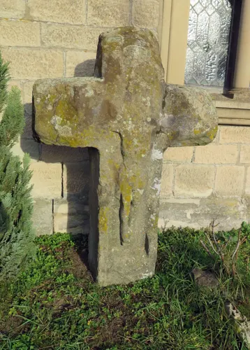
Kreuzstein
Monument and historic site · 0.6 km
Steinkreuz eines Mainschiffers, spätgotisches Steinkreuz mit Relief des gekreuzigten Heiland



Altes Amtsgericht
Monument and historic site · 0.7 km
18 Zwerchmaingasse, Haßfurt
Mo-Fr 08:30-12:30, Th 14:00-17:00
32 more on the map.
Parks, trails and playgrounds22








10 more on the map.
Restaurants and cafes84
Diafa Genuss
Restaurant · Moroccan · 0.8 km
Marokkanisches Restaurant
10 Brückenstraße, Haßfurt
We-Sa 17:00-20:00; Th 11:30-14:00

Restaurant Korfu
Restaurant · Greek · 1.5 km
Griechisches Restaurant
3 Bachstraße, Haßfurt
Mo-Sa 17:00-24:00; Su,PH 11:00-14:00,17:00-24:00

Neumanns kulinarischer Service
Restaurant · Regional · 0.8 km
17 Brückenstraße, Haßfurt
Mo,Tu off; We-Th 11:30-14:00; Th-Sa 17:00-22:00; Su 11:30-14:30
Pizzeria Ristorante Da Giuseppe
Restaurant · Italian · 6.2 km
5 Regiomontanusstraße, Königsberg in Bayern
Tu off
Da Aurélio
Restaurant · Italian, Italian Pizza · 6.3 km
1 Obere Torstraße
Su 11:00-14:00, 17:00-22:00; Mo, We-Sa 17:00-22:00


Gasthaus Drei Linden
Restaurant · Greek · 4.8 km
Mo-Sa 17:00-22:00; We off; Th 17:00-23:00; Fr 17:00-24:00; Su,PH...

72 more on the map.
Where to stay14
Churches and places of worship32
Filialkirche St. Laurentius
Church · Roman Catholic · 5.4 km
11 Kirchenschlag, Haßfurt
St. Johannes der Täufer
Church · Catholic · 2.1 km
11 Dorfstraße, Haßfurt
Shopping26
Gas and EV charging6
Schools, colleges and libraries23
Healthcare9
Map of Haßfurt
250 places. The map loads OpenStreetMap tiles when you open it.
Getting there and nearby towns
Sonderlandeplatz Kitzingen (KZG) is the nearest airport with scheduled flights listed in OpenStreetMap, 39 km away.
- Schweinfurt 21 km west, about 21 min by car
- Werneck 30 km west, about 30 min by car
- Bad Staffelstein 35 km east, about 35 min by car
- Lichtenfels 41 km east, about 41 min by car
- Kitzingen 42 km southwest, about 42 min by car
- Hirschaid 42 km southeast, about 42 min by car
- Höchstadt an der Aisch 42 km southeast, about 42 min by car
- Hammelburg 45 km west, about 45 min by car
- Würzburg 49 km southwest, about 49 min by car
- Forchheim 53 km southeast, about 53 min by car
Drive times are estimates from straight-line distance, not routes.
Local news
Headlines from INDB.
Reviews, tips and questions
Loading what members have shared...
Sources and licences
- GeoNames (CC BY 4.0): population, coordinates, regions and time zone
- Mapillary (see each image): photos
- OpenStreetMap contributors (ODbL 1.0): places, airports, map data
- Wikidata (CC0 1.0): elevation, founding date, time zone, website
- Wikimedia Commons (see each image): photos
- Wikipedia (CC BY-SA 4.0): overview and history text
Photo credits
- Hassfurt BW 3, Berthold Werner, CC BY-SA 3.0
- Haßfurt, Friedhof, Grabmähler-001, Tilman2007, CC BY-SA 3.0
- Haßfurt Ritterkapelle 8171821, Ermell, CC BY-SA 4.0
- Haßfurt, Ritterkapelle (07), Subbass1, CC BY-SA 4.0
- Haßfurt, Ritterkapelle (08), Subbass1, CC BY-SA 4.0
- Choir, Ritterkapelle. Haßfurt 20140801 3, DXR / Daniel Vorndran, CC BY-SA 4.0
- High Altar, Ritterkapelle Haßfurt 20140801 1, DXR / Daniel Vorndran, CC BY-SA 4.0
- D-6-74-147-67 Christuskirche Haßfurt, Empore, Stephan van Helden, CC BY-SA 4.0
- D-6-74-147-67 Christuskirche Haßfurt, Altar, Stephan van Helden, CC BY-SA 4.0
- D-6-74-147-67 Christuskirche Haßfurt, Chorfenster, Stephan van Helden, CC BY-SA 4.0
- D-6-74-147-67 Christuskirche Haßfurt, innen (2), Stephan van Helden, CC BY-SA 4.0
- D-6-74-147-67 Christuskirche Haßfurt, innen (1), Stephan van Helden, CC BY-SA 4.0
- Haßfurt Ritterkapelle Altar 8171826 HDR, Ermell, CC BY-SA 4.0
- D-6-74-147-67 Christuskirche Haßfurt, Glasbild über dem Südeingang (1), Stephan van Helden, CC BY-SA 4.0
- D-6-74-147-67 Christuskirche Haßfurt, Glasbild über dem Südeingang (2), Stephan van Helden, CC BY-SA 4.0
- Haßfurt Ritterkapelle Altar 8171822 HDR, Ermell, CC BY-SA 4.0
- Haßfurt Christuskirche Altar HDR-20250907-RM-170644, Reinhold Möller Ermell, CC BY-SA 4.0
- Haßfurt Christuskirche Orgelempore HDR-20250907-RM-170916, Reinhold Möller Ermell, CC BY-SA 4.0
- Haßfurt Christuskirche Orgelempore HDR-20250907-RM-170935, Reinhold Möller Ermell, CC BY-SA 4.0
- Haßfurt, Ritterkapelle (01), Subbass1, CC BY-SA 4.0
- Regiogym, Joerg Thelenberg, Public domain
- Obertheres Kloster 01, User:presse03 - Künstler unbekannt, Public domain
- Haßfurt, Hauptstraße 88, 86, 001, Tilman2007, CC BY-SA 3.0
- Haßfurt, Maintor, 001, Tilman2007, CC BY-SA 3.0
- Haßfurt, Heideloffplatz, Christuskirche, 001, Tilman2007, CC BY-SA 3.0
- D-6-74-147-148 Hausfigur (1), Stephan van Helden, CC BY-SA 4.0
- D-6-74-147-150 Pfarrkirche Augsfeld (2), Stephan van Helden, CC BY-SA 4.0
- D-6-74-147-165 Pfarrkirche vom Wachthügel, Stephan van Helden, CC BY-SA 4.0
- D-6-74-147-175 Filialkirche St. Laurentius, Stephan van Helden, CC BY-SA 4.0
- Uchenhofen St. Martin 003, Tilman2007, CC BY-SA 3.0
- St. Michael Unterhohenried 001, Tilman2007, CC BY-SA 3.0
- D-6-74-147-202 Kirche (1), Stephan van Helden, CC BY-SA 4.0
- Königsberg in Bayern, Hellingen, Evangelische Kirche-20160320-003, Tilman2007, CC BY-SA 4.0
- Kirche Roemershofen 003, Tilman2007, CC BY-SA 3.0
- NSG-Mainaue-Augsfeld-5154038, ermell, CC BY-SA 4.0
- Wiese an der Hohen Wann, Stephan van Helden, CC BY-SA 4.0
- Wonfurt Schloss -20231015-RM-162438, Ermell, CC BY-SA 4.0
- Haßfurt, Friedhof, Friedhofskreuz 20170204-001, Tilman2007, CC BY-SA 4.0
- Hohe Wann von Norden, Stephan van Helden, CC BY-SA 4.0
- See in der Mainaue bei Augsfeld (3), Stephan van Helden, CC BY-SA 3.0
- D-6-74-147-12 Wohnhaus, Stephan van Helden, CC BY-SA 4.0
- Ritterkapelle Haßfurt, VideoPfarreiHassfurt, CC BY-SA 4.0
- Altershausen Moritzkirche 008, Tilman2007, CC BY-SA 3.0
- Zeil am Main, St Michael 001, Mattana, CC BY-SA 3.0
- Informationstafel Vogelparadies im Maintal auf dem Aussichtsturm am Sichelsee bei Augsfeld, Stephan van Helden, CC BY-SA 4.0
- Auf dem Aussichtspunkt Wart bei Königsberg, Stephan van Helden, CC BY-SA 4.0
- D-6-74-147-226 Lindenhain, Stephan van Helden, CC BY-SA 4.0
- Street-level photo, changchun1, CC BY-SA 4.0
- Street-level photo, bernd_niemann, CC BY-SA 4.0
- Street-level photo, wegavision, CC BY-SA 4.0
- Street-level photo, ramap, CC BY-SA 4.0
- Street-level photo, ramap, CC BY-SA 4.0
- Street-level photo, ramap, CC BY-SA 4.0
- Street-level photo, bernd_niemann, CC BY-SA 4.0
- Street-level photo, bernd_niemann, CC BY-SA 4.0
- Street-level photo, bernd_niemann, CC BY-SA 4.0
- Street-level photo, wegavision, CC BY-SA 4.0
- Street-level photo, wegavision, CC BY-SA 4.0
- Street-level photo, changchun1, CC BY-SA 4.0
- Street-level photo, miguel_andrade, CC BY-SA 4.0
- Street-level photo, wegavision, CC BY-SA 4.0
- Street-level photo, changchun1, CC BY-SA 4.0
- Street-level photo, svhelden, CC BY-SA 4.0
- Street-level photo, svhelden, CC BY-SA 4.0
- Street-level photo, wegavision, CC BY-SA 4.0
- Street-level photo, bernd_niemann, CC BY-SA 4.0
- Street-level photo, bernd_niemann, CC BY-SA 4.0
- Street-level photo, changchun1, CC BY-SA 4.0
- Street-level photo, svhelden, CC BY-SA 4.0
- Street-level photo, tian, CC BY-SA 4.0
- Street-level photo, changchun1, CC BY-SA 4.0
- Street-level photo, zoegglmeyr, CC BY-SA 4.0
- Street-level photo, svhelden, CC BY-SA 4.0
- Street-level photo, ramap, CC BY-SA 4.0
- Street-level photo, svhelden, CC BY-SA 4.0
- Street-level photo, svhelden, CC BY-SA 4.0
- Street-level photo, miguel_andrade, CC BY-SA 4.0
- Street-level photo, svhelden, CC BY-SA 4.0
- Street-level photo, ramap, CC BY-SA 4.0


Page built November 8, 2026. Spotted a mistake? Tell us or suggest a place.