


Morsbach, Germany
Morsbach is a town of 11,630 people in North Rhine-Westphalia, Germany.
Why visit Morsbach
Townapedia lists 22 museums and landmarks, 11 parks and trails, 21 places to eat, 4 places to stay and 6 attractions in and around town.
Highlights include Aussichtsturm Morsbach, Hollenstein, Wissertalbahn and Wissertalbahn.
Weather in Morsbach
Forecast from MET Norway (CC BY 4.0). Full forecast
About Morsbach
Morsbach (German pronunciation: [ˈmɔʁsbax]) is a municipality in Oberbergischer Kreis, a district in North Rhine-Westphalia near the border of Rhineland-Palatinate in Germany. In 2015, Morsbach's population was 10,600. The central village, also named Morsbach, has a population of 3,400. With a number of buildings dating back to the 12th century, it is a popular spot for hikers and other nature lovers.
From the Wikipedia article Morsbach (this version), under CC BY-SA 4.0.
Things to do6

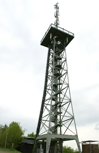
Aussichtsturm Morsbach
Scenic view · 0.7 km
168 Stahlstufen, begehbar bis zur Platform in 30m Höhe, frei Zugänglich, ohne Öffnungszeiten oder Eintrittsgelder.
Müeschbejer Repu-BLICK
Scenic view · 1.0 km
Https://www.rheinische-anzeigenblaetter.de/morsbach/c-nachrichten/panoramablick-auf-die-republik_a255653
Museums and landmarks22

Wissertalbahn
Monument and historic site · 2.3 km
Strecke steht unter Denkmalschutz und wird von einem priv. Verein weiterbetrieben
Wissertalbahn
Monument and historic site · 1.7 km
Strecke steht unter Denkmalschutz und wird von einem priv. Verein weiterbetrieben
Gl. 1
Monument and historic site · 0.7 km
Strecke steht unter Denkmalschutz und wird von einem priv. Verein weiterbetrieben


10 more on the map.
Parks, trails and playgrounds11




Restaurants and cafes21

Rolandsburg
Restaurant · German · 0.6 km
51 Bahnhofstraße, Morsbach
Tu-Sa 11:00-15:00,17:00-24:00; Su 11:30-14:30,17:30-21:00


Tri Angeli
Restaurant · Indian, Italian · 3.9 km
1 Siegener Straße, Morsbach
We-Fr 11:30-14:00, 17:30-22:30; Sa 17:30-22:30; Su 11:30-14:30, 17:30-21:30

Restaurant Wildenburger Hof
Restaurant · German · 5.8 km
Jan: off; Feb-Dec: Mo-Th off; Fr-Su, PH 12:00-22:00

Das Lädchen
Bakery · 3.9 km
8,8a Morsbacher Straße, Morsbach
Mo-Fr 06:00-13:00; Sa 06:00-11:00; Su 07:30-11:00


9 more on the map.
History
4000-1800 BC: First settlement in the region, dating back to the Neolithic Age. A stone hatchet and a fragment of a flint blade have been found.
800 AD: Morschbach is part of Charlemagne's Holy Roman Empire. The parish of Morsbach was administered by the court officials of Sayn.
895: Morsbach is first mentioned in Duplicate of an Archival Book of the Inhabitants of Bonn, Saint Cassius Parish, which also mentions the Oberberg communities.
31 March 1131: Pope Innocent II mentions the Morsbach church.
1174: The counts along the Wupper received Windeck Castle from Earl Heinrich Raps of Thuringia as a gift.
c. 1500: A chapel is built in Holpe as a branch church of Morsbach.
1563: The counts of Sayn-Homburg authorize a Lutheran church. The parish of Morsbach remains Catholic, and the Lutheran parish is in Holpe.
1634: Morsbach becomes a fiefdom of Count Hermann von Hatzfeldt.
1795: During the War of the First Coalition, French forces cross the Rhine, seize the Duchy of Berg and camp in Morsbach.
1805: Prince-elector Maximilian Joseph von Pfalz-Zweibrücken forms an alliance with Napoleon and becomes the king of Bavaria.
1806: Berg becomes a grand duchy, with Joachim Murat (Napoleon's brother-in-law) its regent.
1932: Kreis Waldbröl and Gummersbach are combined to form Oberbergischer Kreis. Morsbach has about 5,300 inhabitants, and its borders have been nearly unchanged for centuries.
From the History section of Morsbach on Wikipedia, under CC BY-SA 4.0.
Where to stay4
Churches and places of worship19
St. Elisabeth
Church · Roman Catholic · 4.7 km
203 Hauptstraße, Birken-Honigsessen
Unbeflecktes Herz Mariä
Church · Roman Catholic · 1.8 km
7 Ehrenstraße, Morsbach
Shopping5
Gas and EV charging3
Schools, colleges and libraries5
Healthcare3
Map of Morsbach
99 places. The map loads OpenStreetMap tiles when you open it.
Getting there and nearby towns
Siegerlandflughafen (SGE) is the nearest airport with scheduled flights listed in OpenStreetMap, 31 km away.
- Waldbröl 8 km west, about 8 min by car
- Nümbrecht 14 km west, about 14 min by car
- Ruppichteroth 17 km west, about 17 min by car
- Olpe 20 km northeast, about 20 min by car
- Siegen 21 km east, about 21 min by car
- Neunkirchen 20 km east, about 20 min by car
- Much 23 km west, about 23 min by car
- Netphen 27 km east, about 27 min by car
- Wilnsdorf 27 km east, about 27 min by car
- Overath 32 km west, about 32 min by car
Drive times are estimates from straight-line distance, not routes.
Local news
Headlines from INDB.
Reviews, tips and questions
Loading what members have shared...
Sources and licences
- GeoNames (CC BY 4.0): population, coordinates, regions and time zone
- Mapillary (see each image): photos
- OpenStreetMap contributors (ODbL 1.0): places, airports, map data
- Openverse (see each image): photos
- Wikidata (CC0 1.0): elevation, founding date, time zone, website
- Wikimedia Commons (see each image): photos
- Wikipedia (CC BY-SA 4.0): overview and history text
Photo credits
- Morsbach 27 ies, Frank Vincentz, CC BY-SA 3.0
- Schloss Crottorf Torbau, andreast , "Schloß Crottorf", CC BY 2.0 de
- Alzen, Herz-Mariä-Kirche, Rauenstein, CC BY-SA 3.0
- St. Elisabeth Birken-Honigsessen 2009, Elke Wetzig ( Elya ), CC BY-SA 3.0
- Lichtenberg, Kirche St. Joseph, Rauenstein, Public domain
- Morsbach Bahnhof01 2014-06-29, KlausFoehl, CC BY-SA 3.0
- Emporenbasilika Sankt Gertrud in Morsbach, René Kirchhoff, CC BY-SA 4.0
- Holpe Flockenberg Antoniuskapelle, Reneman, CC BY-SA 4.0
- Aussichtsturm Hohe Hardt, fototraber, CC BY 2.0
- Street-level photo, dmarci, CC BY-SA 4.0


Page built November 8, 2026. Spotted a mistake? Tell us or suggest a place.