


Why visit Bacup
Townapedia lists 1 museum or landmark, 2 parks and trails, 3 places to eat and 1 attraction in and around town.
Weather in Bacup
Forecast from MET Norway (CC BY 4.0). Full forecast
About Bacup
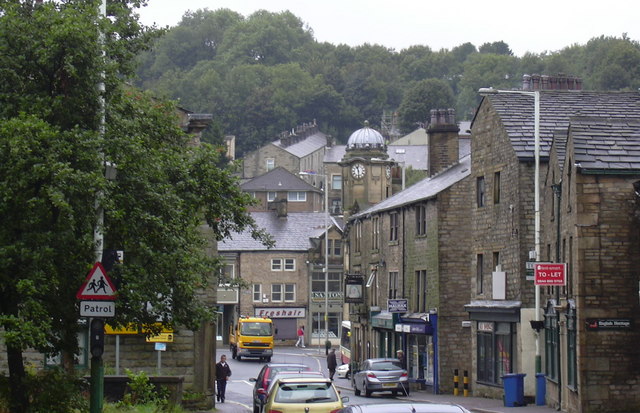
Bacup is a town in the Rossendale Borough in Lancashire, England, in the South Pennines close to Lancashire's boundaries with West Yorkshire and Greater Manchester. The town is in the Rossendale Valley and the upper Irwell Valley, 4 miles (6.4 km) east of Rawtenstall, 6 miles (9.7 km) north of Rochdale, and 7 miles (11 km) south of Burnley. At the 2011 Census, Bacup had a population of 13,323.
From the Wikipedia article Bacup (this version), under CC BY-SA 4.0.
Travel tips from other travellers: Bacup on Wikivoyage (CC BY-SA 4.0).
Things to do1

Museums and landmarks1

Parks, trails and playgrounds2


Restaurants and cafes3



History
The name Bacup is derived from the Old English fūlbæchop. The Oxford Dictionary of British Place Names translates this as "muddy valley by a ridge"; the fūl- element, which meant "foul" or "muddy" was used in the earliest known reference to the area, in a charter by Robert de Lacey, around the year 1200, as used in the Middle English spelling fulebachope. The prefix ful- was dropped from the toponym. The -bæchop element is less clear, possibly meaning "ridge valley", or else "back valley" referring to the locale's position at the back part of the Irwell Valley.
Bacup and its hinterland has provided archeological evidence of human activity in the area during the Neolithic. Anglo-Saxons settled in the Early Middle Ages. It has been claimed that in the 10th century the Anglo-Saxons battled against Gaels and Norsemen at Broadclough, a village to the north of Bacup. From the medieval period in this area, the River Irwell separated the ancient parishes of Whalley and Rochdale (in the hundreds of Blackburn and Salford respectively). The settlement developed mainly in the Whalley township of Newchurch but extending into Rochdale's Spotland.
Read more of the history
The geology and topography of the village lent itself to urbanisation and domestic industries; primitive weavers' cottages, coal pits and stone quarries were propelled by Bacup's natural supply of water power in the Early Modern period. The adoption of the factory system, which developed into the Industrial Revolution, enabled the transformation of Bacup from a small rural village into a mill town, populated by an influx of families attracted by Bacup's cotton mills, civic amenities and regional railway network. Locally sourced coal provided the fuel for industrial-scale quarrying, cotton spinning and shoemaking operations, stimulating the local economy. Bacup received a charter of incorporation in 1882, giving it honorific borough status and its own elected town government, consisting of a mayor, aldermen and councillors to oversee local affairs.
Bacup's boom in textile manufacture during the Industrial Revolution resulted in the town developing into a prosperous and thickly populated industrial area by early-20th century. But the Great Depression and the ensuing deindustrialisation of the United Kingdom largely eliminated Bacup's textile processing sector and economic prosperity.
Bacup followed the regional and national trend of deindustrialisation during the early and mid-20th century; a process exacerbated by the closure of Bacup railway station in 1966. Bacup also experienced population decline; from 22,000 at the time of the United Kingdom Census 1911, to 15,000 at the United Kingdom Census 1971. Much of Bacup's infrastructure became derelict owing to urban decay, despite regeneration schemes and government funding. Shops became empty and some deteriorated. The houses along the main roads endured as the original terraces from Bacup's industrial age, but behind these, on the hillsides, are several council estates.
Records in 2005 show Bacup to have some of the lowest crime levels in the county, and the relative small change to Bacup's infrastructure and appearance has given the town a "historic character and distinctive sense of place". In 2007, the murder of Sophie Lancaster attracted media attention to the town and highlighted its urban blight and lack of amenities and regeneration.
From the History section of Bacup on Wikipedia, under CC BY-SA 4.0.
More about Bacup
Geography
At 53°42′14″N 2°11′56″W (53.704°, −2.199°), 15 miles (24.1 km) north-northeast of Manchester, 17 miles (27.4 km) southeast of Blackburn and 26 miles (41.8 km) southwest of Bradford. Bacup stands on the western slopes of the South Pennines, amongst the upper-Irwell Valley. The River Irwell, a 39-mile (63 km) long tributary of the River Mersey, runs southwesterly through Bacup towards Rawtenstall from its source by the town's upland outskirts at Weir. The Irwell is mostly culverted in central Bacup but it is open in the suburbs. In 2003 there was a proposal to use plate glass for a section of the culvert in the centre of the town however the culvert was eventually replaced with concrete. Bacup is roughly 1,000 feet (305 m) above sea level; the Deerplay area of Weir is 1,350 feet (411 m) above sea level; Bacup town centre is 835 feet (255 m) above sea level.
Economy
Bacup’s economy reflects its industrial heritage and ongoing transition toward a more diversified local base. While traditional textile and footwear manufacturing declined during the late 20th century, the town is now home to a range of small and medium-sized enterprises across sectors such as engineering, plastics, furniture, and e-commerce.
Modern employment sites include Futures Park and New Line Industrial Estate, which support local businesses involved in production, distribution, and services. Companies with operations in Bacup include Orthoplastics, JJO plc, Dale Print, AV.com (a subsidiary of Gear4music), and the Lancashire Sock Manufacturing Company.
Although Bacup forms part of the broader Pennine Lancashire economy, it retains a distinct local employment profile shaped by manufacturing and logistics. The workforce is concentrated in skilled trades, machine operation, and warehousing roles, reflecting the area’s stock of light industrial units and repurposed factory buildings. Business activity in the town also includes niche and specialist manufacturing, supported by regional transport links via the A681 and proximity to the M66 corridor.
Arts and culture
The key date in Bacup's cultural calendar is Easter Saturday, when the Britannia Coconut Dancers beat the bounds of the town via a dance procession. Britannia Coconut Dancers are an English country dance troupe from Bacup whose routines are steeped in local folk tradition. They wear distinctive costumes and have a custom of blackening their faces. The origin of the troupe is claimed to have its roots in Moorish, pagan, medieval, mining and Cornish customs. The Easter Saturday procession begins annually at the Traveller's Rest Public House on the A671 road. The dancers are accompanied by members of Stacksteads Silver Band and proceed to dance their way through the streets.
Bacup Museum is local history hub and exhibition centre in Bacup. The Bacup Natural History Society was formed in 1878. The work of the society is carried out by a group of volunteers who have a base in the Bacup Museum which contains many domestic, military, industrial, natural history, and religious collections.
From the Wikipedia article Bacup, under CC BY-SA 4.0.
Notable people from Bacup
 Matty JamesEnglish association football player (born 1991)Photo: MilesaMFC, CC0
 Reece JamesEnglish association football player (1993-)Photo: Ungry Young Man, CC BY 2.0
 Paul StephensonBritish police officerPhoto: ukhomeoffice, CC BY 2.0
 John B. SutcliffeEnglish and American architectPhoto: Oak Leaves Oak Park, part of Chicago..., Public domain
- Johnny CleggBritish and South African musician, anthropologist and anti-apartheid icon
- Marc PughEnglish association football player (born 1987)
- J. A. RatcliffeBritish physicist
- Sam AstonBritish actor
- Dick HoworthEnglish Test and County cricketer (1909-1980)
- Jenny RandlesBritish writer
- Jim MeadowcroftBritish snooker player, coach and commentator (1946-2015)
- John KellyLancashire and Derbyshire cricketer (1922-1979)
Born in Bacup, according to Wikidata (CC0). Each name links to its Wikipedia article.
Churches and places of worship7
Shopping3
Gas and EV charging1
Schools, colleges and libraries9
Bacup Holy Trinity Stacksteads Church of England Primary School
School · Anglican · 1.1 mi
Booth Road, Bacup
St Joseph's Roman Catholic Primary School, Stacksteads, Bacup
School · Roman Catholic · 0.9 mi
Huttock End Lane, Bacup
St Mary's Roman Catholic Primary School, a Voluntary Academy
School · Roman Catholic · 0.4 mi
Tong Lane, Bacup
Map of Bacup
27 places. The map loads OpenStreetMap tiles when you open it.
Getting there and nearby towns
Leeds Bradford Airport (LBA) is the nearest airport with scheduled flights listed in OpenStreetMap, 25 miles away.
- Rawtenstall 3 mi west, about 6 min by car
- Todmorden 4 mi east, about 7 min by car
- Haslingden 5 mi west, about 8 min by car
- Littleborough 6 mi southeast, about 10 min by car
- Ramsbottom 6 mi southwest, about 10 min by car
- Burnley 7 mi north, about 11 min by car
- Padiham 8 mi northwest, about 13 min by car
- Brierfield 8 mi north, about 14 min by car
- Nelson 9 mi north, about 14 min by car
- Royton 10 mi south, about 16 min by car
Drive times are estimates from straight-line distance, not routes.
Towns near Bacup


Keep exploring
Local news
Headlines from INDB.
Reviews, tips and questions
Loading what members have shared...
Sources and licences
- GeoNames (CC BY 4.0): population, coordinates, regions and time zone
- OpenStreetMap contributors (ODbL 1.0): places, airports, map data
- Wikidata (CC0 1.0): elevation, founding date, time zone, website, landmarks and historic places
- Wikimedia Commons (see each image): photos
- Wikipedia (CC BY-SA 4.0): overview and history text
Photo credits
- Yorkshire Street, Bacup, Robert Wade, CC BY-SA 2.0
- StNicholas, CalTPD, Public domain
- Christ Church, Bacup, robert wade, CC BY-SA 2.0
- Broadclough Dykes, Simon Dalley, CC BY-SA 4.0
- Gateway, Stubbylee Park, Bacup, Dr Neil Clifton, CC BY-SA 2.0
Page built November 10, 2026. Spotted a mistake? Tell us or suggest a place.