




Rawtenstall, United Kingdom
Rawtenstall is a town of 23,000 people in England, United Kingdom.
Why visit Rawtenstall
Townapedia lists 1 museum or landmark, 8 parks and trails, 37 places to eat and 5 attractions in and around town.
Highlights include The Whitaker.
Weather in Rawtenstall
Forecast from MET Norway (CC BY 4.0). Full forecast
About Rawtenstall
Rawtenstall () is a town in the borough of Rossendale, Lancashire, England. The town lies 15 miles (24 km) north of Manchester, 22 miles (35 km) east of Preston and 45 miles (70 km) south east of Lancaster. The town is at the centre of the Rossendale Valley. As of 2022, it had a population of 23,000.
From the Wikipedia article Rawtenstall (this version), under CC BY-SA 4.0.
Travel tips from other travellers: Rawtenstall on Wikivoyage (CC BY-SA 4.0).
Photos of Rawtenstall

Things to do5


Museums and landmarks1

Parks, trails and playgrounds8

Ground work bamboo tunnel.
Playground · 0.7 mi
Bam boo foliage tunnel for children.

Restaurants and cafes37
Woolpack
Bar and pub · 1.3 mi
488-490 Manchester Road, Rossendale
Mo,Tu,We 12:00-23:00; Th,Fr,Sa 12:00-24:00; Su 12:00-22:30

Mr. Fitzpatrick's
Bar and pub · Temperance
Temperance Bar
5 Bank Street, Rossendale
We 11:00-17:00; Th-Fr 10:00-17:00; Sa 10:00-16:00; Su 11:00-15:00


Nino's
Restaurant · Italian
245 Bacup Road, Rossendale
Tu-Th 17:00-22:00; Fr-Sa 17:00-22:30; Su 13:00-21:00

25 more on the map.
History
The earliest settlement at Rawtenstall was probably in the early Middle Ages, during the time when it formed part of the Rossendale Valley in the Honour of Clitheroe, and consisted of simple dwellings for forest servants and animals. More substantial buildings may have followed in the 15th and 16th centuries with corn and flour mills.
The town entered a major period of growth during the Industrial Revolution, as new mills were constructed to process cotton. The climate and weather were conducive to the industry, as was the town's nearby location to the rapidly developing industrial and mercantile centre at Manchester, dubbed 'Cottonopolis'. Only a few of these mills survive today, and none are operational anymore. During this period, the brothers Thomas, David and Peter Whitehead became important entrepreneurs in the town. They built a number of mills, including one of the earliest mills in the valley, at Lower Mill, and the still existing Ilex Mill. They also built substantial houses for themselves at Holly Mount, as well as large numbers of terraced houses for their workers. Other industries active in this period included quarrying and small scale coal mining, as well as an expanding commercial sector.
Read more of the history
As with many mid-Lancashire towns, it saw a population decline in the 20th century, going from 30,000 inhabitants in the 1911 census to 21,500 in the 1971 census. With the decline of the traditional manufacturing industries, shoemaking became one of the last survivors. this was usually known locally as the slipper industry, since slipper-making grew from the local processing of felt, which itself grew from the textile industry. The firm of H. W. Tricketts, in nearby Waterfoot, had been a major producer and exporter of footwear across the British Empire, but shoemaking declined rapidly from the 1980s. Firms closed as production moved overseas, and the remaining companies are largely importers.
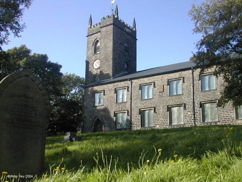
The church of St Nicholas (Church of England) is at Newchurch (rebuilt 1825) as is the Roman Catholic church of St Peter (1892). Other churches are St Michael's Lumb, St James's Waterfoot, St Anne's Edgeside, St John's Cloughfold, St Mary's Oakenhead, St John the Evangelist's Crawshawbooth, St Mary and All Saints Goodshaw (rebuilt 1790). Another RC church (dedicated to St James the Less) is at Oakenhead and there are a number of Nonconformist chapels.
From the History section of Rawtenstall on Wikipedia, under CC BY-SA 4.0.
More about Rawtenstall
Geography
The neighbouring towns in the valley are Bacup, Haslingden and Ramsbottom. The area is bounded to the north by Loveclough and Whitewell Bottom, to the east by Waterfoot and Cowpe and to the south by Townsend Fold and Horncliffe. The River Irwell passes through the town on the first part of its route between Bacup and Manchester, collecting Limy Water close to the junction of Bury Road with Bocholt Way. Over recent years the area has become increasingly popular with visitors, attracted by historic buildings, dramatic landscapes and the heritage railway, the East Lancashire Railway which offers tourists and visitors a chance for days out at Rawtenstall, Ramsbottom and Bury stations among many rural communities along the line.
Arts and culture
Rawtenstall was featured in the documentary series Who Do You Think You Are? which was aired on BBC2 at 9.00pm on 2 February 2006. The subject, actress Jane Horrocks, was born in Rawtenstall in 1964.
The Irwell Sculpture Trail passes through the town, where four of the sculptures are located; the Whispering Wall, the Gateway, the Willow Tree and the Bocholt Tree. The last, by sculptor Bernard Tindall, celebrates Rossendale's twinning links with the town of Bocholt, Germany. The Shoe Trail also passes the outskirts of the town, and goes through nearby places such as Whitaker Park.
Education
The town has a number of primary and secondary (high) schools, including Alder Grange School, Bellmont School, St Paul's C of E Primary, Cloughfold Primary School, Leabrook School and All Saints' Catholic High School. Though located in Waterfoot, rather than Rawtenstall, the traditional grammar school, Bacup and Rawtenstall Grammar School takes part of its name from the town.
Rawtenstall also has a public library, built in 1906 with Carnegie funding.
From the Wikipedia article Rawtenstall, under CC BY-SA 4.0.
Notable people from Rawtenstall
- Jane HorrocksBritish actress
- Lee CartwrightBritish footballer (born 1972)
- Winston PlaceEnglish cricketer (1914-2002)
- Peter HaddonBritish actor (1898-1962)
- Natalie CaseyEnglish actress, singer, presenter, and narrator (born 1980)
- Harry DawsonFootballer (1886-?)
- Russell CuddiheyEnglish footballer (born 1939)
- Mark BrennanProfessional footballer (born 1965)
- Colin BlantEnglish footballer (born 1946)
- Ernest TomlinsonEnglish composer (1924-2015)
- Jonathon Benncricketer (born 1967)
- Thomas HamerParalympic swimmer
Born in Rawtenstall, according to Wikidata (CC0). Each name links to its Wikipedia article.
Churches and places of worship14
Shopping9
Gas and EV charging4
Schools, colleges and libraries15
St James-the-Less Roman Catholic Primary School, Rawtenstall
School · Roman Catholic · 0.4 mi
Unity Way, Rossendale
St Mary's Roman Catholic Primary School, Haslingden
School · Roman Catholic · 1.3 mi
Lime Road, Rossendale
St Peter's Roman Catholic Primary School, Newchurch
School · Roman Catholic · 1.1 mi
St Peter's Road, Rossendale
Healthcare3
Map of Rawtenstall
96 places. The map loads OpenStreetMap tiles when you open it.
Getting there and nearby towns
Manchester Airport (MAN) is the nearest airport with scheduled flights listed in OpenStreetMap, 24 miles away.
- Burnley 7 mi north, about 12 min by car
- Todmorden 8 mi east, about 12 min by car
- Blackburn 9 mi northwest, about 14 min by car
- Bolton 10 mi southwest, about 16 min by car
- Whitefield 10 mi south, about 17 min by car
- Royton 11 mi southeast, about 18 min by car
- Oldham 13 mi southeast, about 21 min by car
- Swinton 14 mi south, about 23 min by car
- Manchester 15 mi south, about 25 min by car
- Salford 15 mi south, about 24 min by car
Drive times are estimates from straight-line distance, not routes.
Towns near Rawtenstall


Keep exploring
Local news
Headlines from INDB.
Reviews, tips and questions
Loading what members have shared...
Sources and licences
- GeoNames (CC BY 4.0): population, coordinates, regions and time zone
- Mapillary (see each image): photos
- OpenStreetMap contributors (ODbL 1.0): places, airports, map data
- Wikidata (CC0 1.0): elevation, founding date, time zone, website, landmarks and historic places
- Wikimedia Commons (see each image): photos
- Wikipedia (CC BY-SA 4.0): overview and history text
Photo credits
- Rawtenstall, Andy4789, CC BY 3.0
- Rossendle Transport buses in Rawtenstall Bus Station, Lancashire 30 January 2007, Paul Anderson, CC BY-SA 2.0
- StNicholas, CalTPD, Public domain
- St Paul's Church, Constable Lee, Dangerousismyname, CC BY-SA 4.0
- St Mary, Rawtenstall, David Dixon, CC BY-SA 2.0
- The Whitaker, Rawtenstall, formerly Rossendale Museum, Lancashire, England 2008, Acabashi, CC BY-SA 4.0
- St Paul's Church Constable Lee 20200911, Wilbur Platt, CC BY-SA 4.0
- Street-level photo, endszbrxns, CC BY-SA 4.0
- Street-level photo, endszbrxns, CC BY-SA 4.0
- Street-level photo, endszbrxns, CC BY-SA 4.0
- Street-level photo, southglos, CC BY-SA 4.0
- Street-level photo, endszbrxns, CC BY-SA 4.0
Page built November 10, 2026. Spotted a mistake? Tell us or suggest a place.