

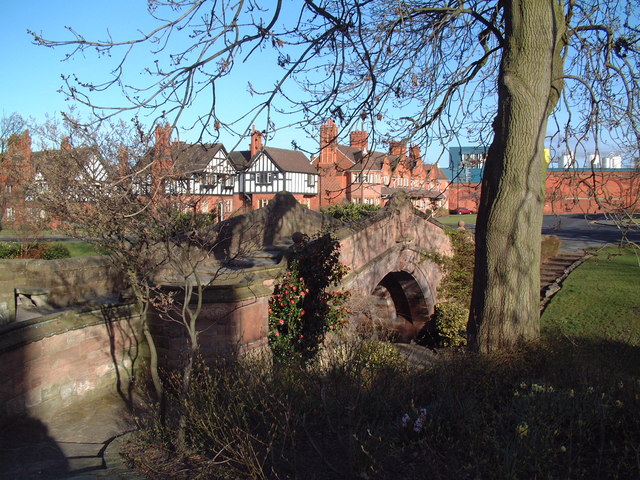


Bebington, United Kingdom
Bebington is a town of 57,600 people in England, United Kingdom.
Why visit Bebington
Townapedia lists 15 museums and landmarks, 12 parks and trails, 53 places to eat, 5 places to stay and 5 attractions in and around town.
Highlights include Dell Bridge, Port Sunlight, Argyle Theatre, Lady Lever Art Gallery and Port Sunlight Museum.
Weather in Bebington
Forecast from MET Norway (CC BY 4.0). Full forecast
About Bebington
Bebington () is a town in the Metropolitan Borough of Wirral, in Merseyside, England. Historically part of Cheshire, it is 5 miles (8 km) south of Liverpool, close to the River Mersey on the eastern side of the Wirral Peninsula. Nearby towns include Birkenhead and Wallasey to the north-northwest, and Heswall to the west-southwest.
From the Wikipedia article Bebington (this version), under CC BY-SA 4.0.
Photos of Bebington


Things to do5

Dell Bridge, Port Sunlight
Bridge · 0.8 mi
Grade II listed bridge in Wirral

Argyle Theatre
Cinema and theater · 2.8 mi
Former theatre, music hall and cinema in Birkenhead, England


Museums and landmarks15

Lady Lever Art Gallery
Museum · 0.8 mi
Art museum in Wirral, Merseyside, England, UK
Lower Road, Wirral


Birkenhead Priory
Museum · 2.7 mi
Monastery and musem in Wirral, United Kingdom

Birkenhead War Memorial
Monument and historic site · 3.0 mi
Grade II listed war memorial in Wirral, Merseyside, England, UK

John Lennon Peace Monument
Monument and historic site · 3.4 mi
Monument dedicated to the memory of John Lennon in Liverpool

Leverhulme Memorial
Monument and historic site · 0.8 mi
Memorial in Port Sunlight, Merseyside, England, UK

Monument to the Mersey Tunnel
Monument and historic site · 2.7 mi
Monument in Birkenhead, Merseyside, England, UK

Port Sunlight War Memorial
Monument and historic site · 0.8 mi
Grade I listed war memorial in Wirral, Merseyside, England, UK

Queen Victoria Monument, Birkenhead
Monument and historic site · 3.0 mi
Monument in Birkenhead, Merseyside, England, UK
War Memorial
Monument and historic site · 0.8 mi
The Causeway, Port Sunlight

Williamson Art Gallery and Museum
Museum · 2.6 mi
Art museum in Wirral, Merseyside, England, UK

Brimstage Hall
Monument and historic site · 1.5 mi
Grade I listed hall & tower, possible medieval.
3 more on the map.
Parks, trails and playgrounds12


Birkenhead Park
Park · 3.1 mi
Public park in Birkenhead, Wirral, Merseyside, England, UK
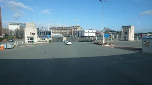
Dock Branch Park
Park · 2.8 mi
Proposed public park in Birkenhead, Merseyside, England, UK, due to open in 2023



New Ferry Butterfly Park
Hiking and trails · 0.8 mi
UK urban nature reserve
Howell Road, Wirral

Hillsborough Memorial Garden
Park · 0.8 mi
Dedicated space commemorating the 97 victims of the 1989 tragedy, particularly the 12 from Wirral and Ellesmere Port
24/7

Restaurants and cafes53




Nettle Cafe And Bookstore
Cafe · 0.8 mi
Mo,We-Fr 09:00-16:00; Sa,Su 09:00-15:30; Tu off
41 more on the map.
History
The name Bebington is derived from the Anglo-Saxon meaning the "Village of Bebba", probably a Saxon chief or landowner.
The area is thought to be the site of the "Birth of England" at the Battle of Brunanburh in 937,
an English victory by the army of Æthelstan, King of England, and his brother Edmund over the combined armies of Olaf Guthfrithson, King of Dublin, Constantine II, King of Alba, and Owain ap Dyfnwal, King of the Cumbrians. Though relatively little known today, it was called "the greatest single battle in Anglo-Saxon history before Hastings." Michael Livingston claimed that Brunanburh marks "the moment when Englishness came of age." The Brackenwood golf course was cited in 2004 as the most likely site for the Battle of Brunanburh.
Mention of the battle is made in dozens of sources, in Old English, Latin, Irish, Welsh, Anglo-Norman and Middle English, and there are many later accounts or responses to the battle. A contemporary record of the battle is found in the Old English poem Battle of Brunanburh, preserved in the Anglo-Saxon Chronicle.
The Church of St. Andrew, on a site occupied since Saxon times, dates from the 14th and 16th centuries.
Read more of the history
In 1801, Bebington was a small country hamlet with a population of only 273, situated on the main road connecting Chester and Birkenhead, and then via ferry to Liverpool. Up to 30 horse-drawn coaches would pass by each day. By 1840, the Birkenhead to Chester railway was running and in 1844 the New Chester Road opened and Bebington lost its coaching traffic.
In 1838, the footprints of an archosaur later called the Chirotherium storetonese were found in a sandstone bed at Storeton Quarry. Examples can be seen at the Liverpool Museum and at Christ Church within the parish of Higher Bebington. Also a small example can be seen at Higher Bebington Junior School, in their reception area.
Stone quarried at Bebington was used for the construction of Birkenhead Town Hall, some of the villas around Birkenhead and Rock Parks and most famously of all the Empire State Building in New York City. The stone is considered to be a high quality sandstone which is creamy in appearance. The quarries were eventually filled in with debris removed during the construction of the two Mersey Tunnels.
Mayer Hall, in Lower Bebington village, was formerly an art gallery built by Bebington philanthropist Joseph Mayer, a noted antiquarian, whose collection of Anglo-Saxon antiquaries helped in the development of British archaeology. He made Pennant House his home. It is still a community resource and boasts many of its original features.
From the History section of Bebington on Wikipedia, under CC BY-SA 4.0.
More about Bebington
Geography
Bebington is on the eastern side of the Wirral Peninsula, approximately 10 km (6.2 mi) south-south-east of the Irish Sea at New Brighton, about 7.5 km (4.7 mi) east-north-east of the Dee Estuary at Gayton and less than 2 km (1.2 mi) west-north-west of the River Mersey at New Ferry. The area is situated at an elevation of between 20–60 m (66–197 ft) above sea level.
Education
Bebington contains ten main schools; Wirral Grammar School for Boys, Wirral Grammar School for Girls, St John Plessington Catholic College, St John's Junior and Infant Schools, Higher Bebington Junior School, Co-op Academy Bebington, Brackenwood Junior School, Stanton Road Primary School, St Andrew's Primary School, Town Lane Infants School, Church Drive Primary School.
From the Wikipedia article Bebington, under CC BY-SA 4.0.
Notable people from Bebington
 Lottie DodEnglish tennis player (1871-1960)Photo: http://en.wikipedia.org/wiki/User:Scewing, Public domain
 Michael GoodliffeEnglish actor (1914-1976)Photo: Production company: Hammer Film Productions, Public domain
 Chris SharrockBritish drummerPhoto: Raph_PH, CC BY 2.0
 Dom PhillipsBritish journalist, writer, editorPhoto: Marcos Corrêa/Presidência da República, CC BY 2.0
 Jean BohtEnglish actress (1932-2023)Photo: Simon Harries, CC BY 2.0
 Phil Liggettsports journalist, commentatorPhoto: jjron, GFDL 1.2
 Christopher DraperBritish WWI flying ace (1892-1979)Photo: Unknown author Unknown author, Public domain
- William DodBritish archer (1867–1954)
- Hilda Ellis DavidsonBritish academic (1914-2006)
- Banner JohnstoneBritish rower (1882-1964)
- John Graham KenionOlympic sailor (1871–1942)
- Harry Makepeacecricket and football player from England (1881-1952)
Born in Bebington, according to Wikidata (CC0). Each name links to its Wikipedia article.
Where to stay5
Village Hotel Bromborough
Motel and hotel · 1.3 mi
Village Urban Resort Pool Lane, Wirral
Churches and places of worship39
Christ Church
Church · United Reformed · 0.9 mi
Church Drive, Port Sunlight
Shopping4
Gas and EV charging4
Schools, colleges and libraries19
Healthcare11
Map of Bebington
167 places. The map loads OpenStreetMap tiles when you open it.
Getting there and nearby towns
Liverpool John Lennon Airport (LPL) is the nearest airport with scheduled flights listed in OpenStreetMap, 7 miles away.
- Bromborough 2 mi east, about 2 min by car
- Prenton 2 mi northwest, about 3 min by car
- Birkenhead 3 mi north, about 5 min by car
- Dingle 3 mi northeast, about 5 min by car
- Heswall 4 mi southwest, about 6 min by car
- Liverpool 4 mi north, about 7 min by car
- Mossley Hill 5 mi northeast, about 8 min by car
- Neston 5 mi south, about 8 min by car
- Wallasey 5 mi north, about 9 min by car
- Allerton 5 mi east, about 8 min by car
Drive times are estimates from straight-line distance, not routes.
Towns near Bebington


Keep exploring
Local news
Headlines from INDB.
Reviews, tips and questions
Loading what members have shared...
Sources and licences
- GeoNames (CC BY 4.0): population, coordinates, regions and time zone
- Mapillary (see each image): photos
- OpenStreetMap contributors (ODbL 1.0): places, airports, map data
- Wikidata (CC0 1.0): elevation, founding date, time zone, website, landmarks and historic places
- Wikimedia Commons (see each image): photos
- Wikipedia (CC BY-SA 4.0): overview and history text
Photo credits
- StAndrewsBebington1, Ej.culley, CC BY-SA 4.0
- Dell Bridge, David Squire, CC BY-SA 2.0
- Lady Lever Art Gallery, Port Sunlight - IMG 0915, Rept0n1x, CC BY-SA 3.0
- Birkenhead Priory from St Mary's Tower 2019-2, Rodhullandemu, CC BY-SA 4.0
- Birkenhead War Memorial, Rodhullandemu, CC BY-SA 4.0
- John Lennon peace memorial, Echo Arena 1, Rodhullandemu, CC BY-SA 4.0
- Queensway tunnel pylon in Birkenhead, Rept0n1x, CC BY-SA 3.0
- Queen Victoria Monument, Birkenhead, Rodhullandemu, CC BY-SA 4.0
- Williamson Art Gallery, Oxton, Merseyside, Rept0n1x, CC BY-SA 2.0
- Tree stump sculpture at Port Sunlight River Park (30099888911), Rept0n1x, CC BY-SA 2.0
- Grand Entrance, Birkenhead Park 2019, Rodhullandemu, CC BY-SA 4.0
- Eastham Country Park, Wirral - DSC03452, Rept0n1x, CC BY-SA 3.0
- Otterspool Promenade, Liverpoolpics, CC BY-SA 3.0
- Christ Church, Higher Bebington 1, Rodhullandemu, CC BY-SA 4.0
- All Saints, Thornton Hough 2020-1, Rodhullandemu, CC BY-SA 4.0
- Chapel of the Good Shepherd, Carlett Park 3, Rodhullandemu, CC BY-SA 4.0
- Christ Church, Barnston north side, Rodhullandemu, CC BY-SA 4.0
- Christ Church, Oxton 2018-2, Rodhullandemu, CC BY-SA 4.0
- Christ the King, Birkenhead (4), Rept0n1x, CC BY-SA 3.0
- St Paul's Church, Rock Ferry 2020, Rodhullandemu, CC BY-SA 4.0
- Oxton Congregational church from Balls Road East, Rodhullandemu, CC BY-SA 4.0
- Norwegian Fishermans' Church, Liverpool, Liverpoolpics, CC BY-SA 3.0
- Port Sunlight War Memorial 2020, Rodhullandemu, CC BY-SA 4.0
- Christ Church, Port Sunlight, Rodhullandemu, CC BY-SA 4.0
- The Bridge Inn, Port Sunlight 2020-1, Rodhullandemu, CC BY-SA 4.0
- Port Sunlight buildings 5, Man vyi, Public domain
- Brimstage Hall & Tower 1, Rodhullandemu, CC BY-SA 4.0
- Ectemnius cephalotes 148917387, Roy Lowry, CC BY 4.0
- Episyrphus balteatus 204174889, Roy Lowry, CC BY 4.0
- Myathropa florea 189879064, Roy Lowry, CC BY 4.0
- The Leverhulme Memorial, Port Sunlight, The wub, CC BY-SA 4.0
- New Ferry Park from near the lodge, Rodhullandemu, CC BY-SA 4.0
- Street-level photo, cyclestreets, CC BY-SA 4.0
- Street-level photo, cyclestreets, CC BY-SA 4.0
- Street-level photo, skifans, CC BY-SA 4.0


Page built November 10, 2026. Spotted a mistake? Tell us or suggest a place.