


Billingborough, United Kingdom
Billingborough is a town of 1,837 people in England, United Kingdom.
Why visit Billingborough
Townapedia lists 8 museums and landmarks and 6 places to eat in and around town.
Highlights include Car Dyke and Car Dyke.
Weather in Billingborough
Forecast from MET Norway (CC BY 4.0). Full forecast
About Billingborough
Billingborough is a village and civil parish in the South Kesteven district of Lincolnshire, England. It is situated approximately 10 miles (16 km) north of Bourne and 10 miles south of Sleaford, and on the B1177 between Horbling and Pointon just south of the A52.
From the Wikipedia article Billingborough (this version), under CC BY-SA 4.0.
Museums and landmarks8


Restaurants and cafes6




Churches and places of worship8
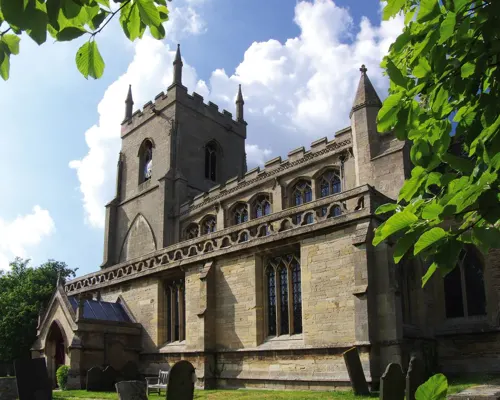
St James' Church, Aslackby
Church · 3.1 mi
Church in Aslackby, Lincolnshire, England, UK

St. Andrew's Church, Folkingham
Church · 2.8 mi
Church in Folkingham, Lincolnshire, England, UK
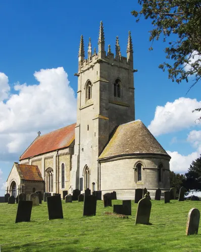


St Andrew's Church, Billingborough
Church
Church in Billingborough, Lincolnshire, England, UK
St Peter's Church, Threekingham
Church · 2.0 mi
Church in Threekingham, Lincolnshire, England, UK
Shopping1

History
The village is named after the post-Roman Billings tribe of invaders. The village was formerly served by the Billingborough and Horbling railway station on the Bourne and Sleaford Railway, giving the village connections to nearby Bourne and Sleaford. The former high school name, Aveland, is taken from a pre-Norman Conquest wapentake of that name, dating to 921. The wapentake extended from Bourne to Threekingham. The area was populous in the Middle Ages, and included the lost village of Ouseby as well as the shrunken village of Birthorpe. St Andrew's Church dates to the 13th century and is in a mixture of Perpendicular Gothic and Decorated styles.
On a Saturday in 1791 a six-hour football match between the 'bachelors' of Osbournby and Billingborough was played at Osbournby field. Billingborough won and were distinguished by the wearing of blue ribbons.
From the History section of Billingborough on Wikipedia, under CC BY-SA 4.0.
Notable people from Billingborough
- Eric HoughtonEnglish footballer and manager (1910-1996)
- Joshua ShawEnglish artist and firearms designer (1776-1860)
- Roy Houghtonassociation football player (born 1921)
- Reg Goodacreassociation football player (1908-1998)
- Nathaniel DickinsonAmerican settler (1601-1676)
Born in Billingborough, according to Wikidata (CC0). Each name links to its Wikipedia article.
Schools, colleges and libraries3
The St Gilbert of Sempringham Church of England Primary School, Pointon
School · Anglican · 1.4 mi
West Road, Sleaford
Map of Billingborough
26 places. The map loads OpenStreetMap tiles when you open it.
Getting there and nearby towns
RAF Coningsby (QCY) is the nearest airport with scheduled flights listed in OpenStreetMap, 16 miles away.
- Sleaford 8 mi north, about 12 min by car
- Bourne 9 mi south, about 14 min by car
- Corby Glen 9 mi southwest, about 15 min by car
- Leasingham 10 mi north, about 16 min by car
- Spalding 11 mi southeast, about 17 min by car
- Cranwell 11 mi northwest, about 18 min by car
- Grantham 13 mi west, about 20 min by car
- Colsterworth 13 mi southwest, about 21 min by car
- Boston 14 mi northeast, about 23 min by car
- Market Deeping 15 mi south, about 24 min by car
Drive times are estimates from straight-line distance, not routes.
Towns near Billingborough


Keep exploring
Local news
Headlines from INDB.
Reviews, tips and questions
Loading what members have shared...
Sources and licences
- GeoNames (CC BY 4.0): population, coordinates, regions and time zone
- Mapillary (see each image): photos
- OpenStreetMap contributors (ODbL 1.0): places, airports, map data
- Wikidata (CC0 1.0): elevation, founding date, time zone, website, landmarks and historic places
- Wikimedia Commons (see each image): photos
- Wikipedia (CC BY-SA 4.0): overview and history text
Photo credits
- Billingborough & Horbling Station 1798658 0fd34a71, Ben Brooksbank, CC BY-SA 2.0
- The Fortescue Arms Pub, Billingborough, Lincolnshire, UK, Heickxopelk, CC BY-SA 4.0
- Folkingham church lincs, Lofty, Public domain
- Horbling St. Andrews Church, JOHN BLAKESTON, CC BY-SA 2.0
- Car Dyke, David Gruar, CC BY-SA 2.0
- Tappy, Katoollie, CC BY-SA 3.0
- The Plough Inn, Horbling, Lincolnshire, UK, Heickxopelk, CC BY-SA 4.0
- Street-level photo, coljay72, CC BY-SA 4.0
- Street-level photo, coljay72, CC BY-SA 4.0
Page built November 10, 2026. Spotted a mistake? Tell us or suggest a place.