




Cherry Burton, United Kingdom
Cherry Burton is a town of 1,392 people in England, United Kingdom.
Why visit Cherry Burton
Townapedia lists 3 museums and landmarks, 2 parks and trails and 5 places to eat in and around town.
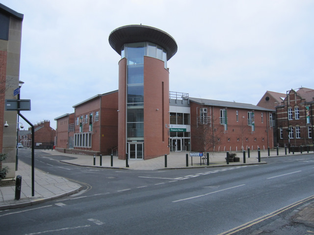
Highlights include The Beverley Treasure House and Beverley Guildhall.
Weather in Cherry Burton
Forecast from MET Norway (CC BY 4.0). Full forecast
About Cherry Burton
Cherry Burton is a village and civil parish in the East Riding of Yorkshire, England. It is approximately 3 miles (5 km) north-west of the market town of Beverley, 9 miles (14 km) east of Market Weighton and 11 miles (18 km) south west of Driffield. The village lies on the eastern edge of the Yorkshire Wolds and lies to the west of the B1248 road.
From the Wikipedia article Cherry Burton (this version), under CC BY-SA 4.0.
Museums and landmarks3

The Beverley Treasure House
Museum · 3.4 mi
History museum in East Riding of Yorkshire, England

Beverley Guildhall
Museum · 3.3 mi
Grade I listed building in Beverley, East Riding of Yorkshire, England, UK

Parks, trails and playgrounds2


Restaurants and cafes5


Churches and places of worship12

Church of Saint Michael
Church · 0.4 mi
Church building in Cherry Burton, East Riding of Yorkshire, England, UK

Church of St Catherine
Church · 2.0 mi
Grade I listed church in Leconfield, East Riding of Yorkshire, England, UK

Church of St Mary
Church · 0.9 mi
Church in Etton, East Riding of Yorkshire, England, UK

St Mary's Church, Beverley
Church · 3.1 mi
Church in Beverley, East Riding of Yorkshire, England, UK


Church of All Saints
Church · 1.5 mi
Church in Bishop Burton, East Riding of Yorkshire, England, UK
Church of Saint Mary
Church · 2.4 mi
Grade I listed church in South Dalton, East Riding of Yorkshire, England, UK
Church of St Leonard
Church · 2.6 mi
Church in Scorborough, East Riding of Yorkshire, England, UK
Church of St Mary
Church · 3.0 mi
Church in Lockington, East Riding of Yorkshire, England, UK
History
The village is mentioned in the Domesday Book as Burtone, and belonging to the then Archbishop of York. The name derives from a combination of Old and Middle English; Burh-tūn and Chiri, which means a fort enclosure; a farm with a palisade and a cherry tree. Due to its location, some 1.2 miles (2 km) north of Bishop Burton, the village was sometimes known as North Burton (or even rarer, as Sheriff Burton).
Historically in the Wapentake of Harthill, the village also came under the Beverley for its local district. Until rapid housebuilding in the 1960s and 1970s, the village mostly consisted of one long main street as laid down in the 18th and 19th centuries with farmhouses.
The civil parish is formed by the village of Cherry Burton and the hamlets of Gardham and High Gardham. According to the 2011 UK Census, Cherry Burton parish had a population of 1,392, a reduction on the 2001 UK Census figure of 1,473.
The village has a Costcutter shop which also acts as a post office and a village hall which holds live musical events and hosts an annual local pantomime. The village pub, The Bay Horse, holds events each week. The village has a primary school which has ties with the local church. Its rating by OFSTED is good.
Read more of the history
Sports in the village include cricket, football, tennis, and rounders. Clubs for cricket and football have junior sections. Just outside of the village is a golf course and leisure park currently under development. A Wesleyan Methodist chapel was built in 1824, followed by a Primitive Wesleyan Methodist chapel in 1851; both have ceased being used for worship with the Wesleyan chapel now being the village hall. St Michael's Church, Cherry Burton was built in 1852, which is now grade II listed. It was built on the site of a previous undated church.
The village is one of the few in the UK awarded Fairtrade Village status for promoting fairtrade and local produce. It gained this status on 22 July 2003 and was the second village to do so. In 2011–2012, a flood alleviation scheme was implemented with funding from DEFRA. Like many other places in the East Riding of Yorkshire, Cherry Burton was subject to severe flooding in the 2007 floods.
Cherry Burton was served by Cherry Burton railway station on the York to Beverley Line between 1865 and 1959, with the station remaining open for another five years for the inward and outward transportation of agricultural produce. The line closed completely in 1965. In 2018, a new footpath from the village to the old railway line opened, which allowed the inhabitants of Cherry Burton to access the Hudson Way, a foot and cycle path built on the formation of the old railway line. Previous to this, to access the path, villagers needed to negotiate the main road out of the village which had no footpaths and where traffic could travel at 60 miles per hour (97 km/h).
From the History section of Cherry Burton on Wikipedia, under CC BY-SA 4.0.
Schools, colleges and libraries2
Cherry Burton Church of England Voluntary Controlled Primary School
School · Anglican
Main Street, Beverley
Map of Cherry Burton
24 places. The map loads OpenStreetMap tiles when you open it.
Getting there and nearby towns
Humberside Airport (HUY) is the nearest airport with scheduled flights listed in OpenStreetMap, 21 miles away.
- Beverley 3 mi southeast, about 6 min by car
- Walkington 3 mi south, about 5 min by car
- Tickton 5 mi east, about 8 min by car
- Little Weighton 5 mi south, about 9 min by car
- Skidby 6 mi south, about 9 min by car
- North Newbald 6 mi southwest, about 9 min by car
- Dunswell 7 mi southeast, about 11 min by car
- Brough 10 mi south, about 16 min by car
- Driffield 10 mi north, about 16 min by car
- Kingston upon Hull 11 mi southeast, about 17 min by car
Drive times are estimates from straight-line distance, not routes.
Towns near Cherry Burton


Keep exploring
Local news
Headlines from INDB.
Reviews, tips and questions
Loading what members have shared...
Sources and licences
- GeoNames (CC BY 4.0): population, coordinates, regions and time zone
- Mapillary (see each image): photos
- OpenStreetMap contributors (ODbL 1.0): places, airports, map data
- Wikidata (CC0 1.0): elevation, founding date, time zone, website, landmarks and historic places
- Wikimedia Commons (see each image): photos
- Wikipedia (CC BY-SA 4.0): overview and history text
Photo credits
- Cherry Burton c early 60s, Ray Teal,, Attribution
- Cherry Burton, Main Street 1920 (archive ref PO-1-30-7) (26273226982), East Riding Archives, No restrictions
- Treasure House Beverley, John S Turner, CC BY-SA 2.0
- St Catherine Church Leconfield 1, Peter Church, CC BY-SA 2.0
- Beverley - St Mary's Church - 10, Benjamin Smith, CC BY-SA 4.0
- St Michael and All Angels Church Cherry Burton, Dr Patty McAlpin, CC BY-SA 2.0
- St Marys Church Etton 2 (Nigel Coates), Nigel Coates ( talk ), CC BY-SA 3.0
- All Saints Church Bishop Burton, Paul Glazzard, CC BY-SA 2.0
- Street-level photo, aidan573, CC BY-SA 4.0
- Street-level photo, lamaar639, CC BY-SA 4.0
- Street-level photo, aidan573, CC BY-SA 4.0
Page built November 10, 2026. Spotted a mistake? Tell us or suggest a place.