
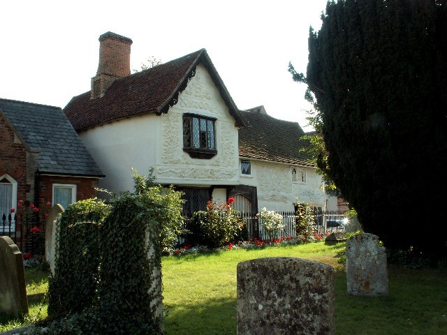


Why visit Clare
Townapedia lists 7 museums and landmarks, 3 parks and trails, 12 places to eat and 1 place to stay in and around town.
Highlights include The Ancient House Museum, Clare Ancient House Museum and Clare Castle Country Park.
Weather in Clare
Forecast from MET Norway (CC BY 4.0). Full forecast
About Clare
Clare is a market town and civil parish on the north bank of the River Stour in the West Suffolk district, in the county of Suffolk, England. Clare is in southwest Suffolk, 14 miles (23 km) from Bury St Edmunds and 9 miles (14 km) from Sudbury. Clare won Village of the Year in 2010 and Anglia in Bloom award for Best Large Village 2011 for its floral displays in 2011. In March 2015, The Sunday Times and Zoopla placed Clare amongst the top 50 UK rural locations, having "period properties and rich history without the chocolate-box perfection – and the coach trips".
From the Wikipedia article Clare, Suffolk (this version), under CC BY-SA 4.0.
Travel tips from other travellers: Clare on Wikivoyage (CC BY-SA 4.0).
Museums and landmarks7

Clare Ancient House Museum
Museum
Medieval timber-framed building and museum in Suffolk, England, United Kingdom



Parks, trails and playgrounds3

Restaurants and cafes12
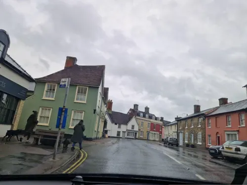

The Bell
Bar and pub
Currently (April 2021) closed, may reopen.
12 Market Hill, Sudbury





Where to stay1
History
Paleolithic implements were discovered within the Priory grounds. A Mesolithic quartzite pebble macehead was found in the same location. A Neolithic stone axe was retrieved from the River Stour; a polished flint axe in a gravel pit to the east and a flint head in a meadow just off the Ashen Road. A Neolithic flint arrowhead was found in a garden on Bridewell Street. A Neolithic long mortuary enclosure and three Bronze Age barrows were located across the river towards Ashen. Evidence of a barrow together with 200 worked flints were found near Chilton Street. A Bronze Age socketed gouge was unearthed from plough soil on the Common. There are some 24 other pre-Iron Age structures in the parishes around Clare which may be located via Google Maps.
Read more of the history
An Iron Age pot was found embedded in the river bank, half a mile east of Clare. Together with an iron spearhead, they are held in The Ancient House. Iron Age coins have also been found, one from the Belgic Trinovantes tribe. In 2009 during a recent rebuilding programme at Clare Community Primary School, postholes of a late Bronze/Early Iron Age structure were located, with an associated ring ditch. This supports the view that Clare Camp (OS TL768458, at the north end of the town, just behind Bridewell Street) with its double ditches, one of the most impressive of its kind in Suffolk, is from that period; with an area of 2.9 hectares, it is second only to Burgh Castle. It is now entered into the Atlas of Hillforts. The north side is most complete, with an inner rampart 9 ft high and counterscarps 12 and 14 ft high. In 1993 a field survey and magnetometric scan revealed the possibility of entrances on the east and south sides. Clare was on the outer borders of the Trinovantes territory, just south of the Iceni. The camp probably marks the first permanent settlement in the area.
A Roman boundary ditch and posthole has been found just off Nethergate Street; a strap fitting, coins, sepulchral urns and a bronze figurine of Mercury or a dancing boy have been unearthed in various locations. Some Roman brick seems to have ended up in the Parish Church.
There were substantial settlements to the west at Wixoe and to the east at Long Melford. Archaeological digs and magnetic survey at Wixoe, as part of the Abberton pipeline installation, revealed a small town occupied from 100-400AD. The Via Devana from Chester to Colchester, a military road, passed through this town. Another road led east from Wixoe, on the north side of the Stour, passing through Long Melford, before heading north-east to Baylham and possibly to Dunwich on the coast; this route is associated with a prehistoric road. No clear trace of this road can now be seen between Wixoe and Cavendish: the agger in the form of terrace has either been eroded by ploughing or incorporated into field boundaries, as is typical in East Anglia.
The name first appears in the Domesday Book of 1086 as 'Clara'. It possibly derives from the "clear" nature of the Chilton Stream as it flows through the town, but from a Latin word rather than a Celtic one as was previously thought. In the Domesday Book, it is described as "Always a market. Now 43 burgesses". Hatton describes this as an "astonishingly high number, because at the time very few Suffolk towns had any burgesses, let alone 43". It lists 37 acres (15 ha) of meadow, woodland for 12 swine, a mill, 5 arpents of vineyard (an arpent was 4–6 acres) and 400 sheep. The manor included Stoke-by-Clare and the hamlet of Chilton Street, totalling 128 households. Improbably it has been suggested that the word claret is derived from Clare and its extensive vineyards. There is a Claret Hall towards Ashen, but that could simply mean 'Little Clare'.
The Domesday Book records that the lands around Clare belonged to a Saxon thane, Aluric (or Aelfric), son of Wisgar (or Withgar) and that he gave them to St John, probably creating in Clare a collegiate church, under Edward the Confessor. William the Conqueror re-granted the land to one of his closest supporters in the Norman Conquest of 1066, Richard fitz Gilbert of Bienfaite, Count of Brionne, the son of one of his cousins, along with 170 other manors, 95 of them in Suffolk. Apart from being related to William, Richard's relationship with the king was further embedded as his father-in-law, Walter Giffard, Lord of Longueville was one of the 15 or so known companions of William at the Battle of Hastings in 1066. This huge feudal barony became known as the Honour of Clare and Richard became known as "Richard de Clare" (or "of Clare") after he made the castle of Clare the administrative centre, or Caput baroniae, of the honour. He also held a large manor in Tonbridge, Kent where he built a motte and bailey castle of a very similar size to Clare Castle. Clare Castle is first recorded in 1090.
After 1066, William was not only King of England but also Duke of Normandy and spent time in both places. When he was away from England, Richard served as joint Chief Justiciar in William's absence, and played a major part in suppressing the revolt of 1075.
His son Gilbert de Clare gave the church in the castle to the Benedictine Bec Abbey in Normandy. Gilbert and his brother were present with Prince Henry when King William II was shot dead by an arrow fired by Walter Tyrell, Gilbert's steward. Tradition is strong that the Clares had staged an assassination. King Henry I was crowned three days later.
In 1124 Gilbert's son Richard de Clare removed the Benedictines to a new foundation in Stoke-by-Clare, which later became a college of priests and was the site of today's Stoke College.
In 1140 Richard's son Gilbert de Clare was given the title of Earl of Hertford by King Stephen. He joined the revolt against the king but later returned to support him.
From the History section of Clare, Suffolk on Wikipedia, under CC BY-SA 4.0.
Notable people from Clare
 George Digby BarkerBritish Army generalPhoto: The photographer is not credited, Public domain
- Richard Fitz Gilbert de ClareNorman nobleman
- Gilbert Fitz RichardAnglo-Norman baron in Wales
Born in Clare, according to Wikidata (CC0). Each name links to its Wikipedia article.
Churches and places of worship6
Shopping6
Schools, colleges and libraries4
Healthcare1
Map of Clare
40 places. The map loads OpenStreetMap tiles when you open it.
Getting there and nearby towns
Cambridge City Airport (CBG) is the nearest airport with scheduled flights listed in OpenStreetMap, 19 miles away.
- Great Yeldham 5 mi south, about 7 min by car
- Haverhill 6 mi west, about 10 min by car
- Steeple Bumpstead 6 mi southwest, about 10 min by car
- Castle Hedingham 6 mi south, about 10 min by car
- Sudbury 7 mi southeast, about 11 min by car
- Great Waldingfield 8 mi east, about 13 min by car
- Lavenham 9 mi east, about 15 min by car
- Halstead 10 mi south, about 15 min by car
- Gosfield 10 mi south, about 16 min by car
- Bury St Edmunds 13 mi northeast, about 21 min by car
Drive times are estimates from straight-line distance, not routes.
Towns near Clare


Keep exploring
Local news
Headlines from INDB.
Reviews, tips and questions
Loading what members have shared...
Sources and licences
- GeoNames (CC BY 4.0): population, coordinates, regions and time zone
- Mapillary (see each image): photos
- OpenStreetMap contributors (ODbL 1.0): places, airports, map data
- Wikidata (CC0 1.0): elevation, founding date, time zone, website, landmarks and historic places
- Wikimedia Commons (see each image): photos
- Wikipedia (CC BY-SA 4.0): overview and history text
Photo credits
- Clare - Ancient House, Robert Edwards, CC BY-SA 2.0
- The Bell, Clare, Robevans123, CC BY-SA 4.0
- Market cross in Clare, Suffolk, Matt Brown, CC BY 2.0
- Nave of Clare Church, Andrewrabbott, CC BY-SA 3.0
- Cavendish - Church of St Mary, ChurchCrawler, CC BY-SA 2.0
- Ancient House, Clare 04, Kognos, CC BY-SA 4.0
- 1194114 I PARISH CHURCH OF SS PETER AND PAUL, seen from the castle Clare 20260525 0005-Pano, Tilman2007, CC BY-SA 4.0
- 1031764 II Star Clare Castle, Keep Clare 20260525 0001, Tilman2007, CC BY-SA 4.0
- 1031743 II Star THE SWAN INN, 4, HIGH STREET Clare 20260525 0002, Tilman2007, CC BY-SA 4.0
- 1194394 II GLOBE INN, 10, CALLIS STREET Clare 20260525 0008, Tilman2007, CC BY-SA 4.0
- 5 and 6, High Street, Clare, Robevans123, CC BY-SA 4.0
- 1194788; 1031714 II 10, MARKET HILL; 11, MARKET HILL Clare 20260525 0001, Tilman2007, CC BY-SA 4.0
- K6 Telephone Kiosk, Market Hill, Clare, Robevans123, CC BY-SA 4.0
- Clare Castle Motte, Evelyn Simak, https://www.geograph.org.uk/profile/14840, CC BY-SA 2.0
- Street-level photo, edloach, CC BY-SA 4.0
- Street-level photo, edloach, CC BY-SA 4.0
- Street-level photo, edloach, CC BY-SA 4.0
- Street-level photo, edloach, CC BY-SA 4.0
- Street-level photo, edloach, CC BY-SA 4.0
- Street-level photo, edloach, CC BY-SA 4.0
- Street-level photo, edloach, CC BY-SA 4.0
- Street-level photo, edloach, CC BY-SA 4.0
- Street-level photo, edloach, CC BY-SA 4.0
- Street-level photo, edloach, CC BY-SA 4.0


Page built November 10, 2026. Spotted a mistake? Tell us or suggest a place.