


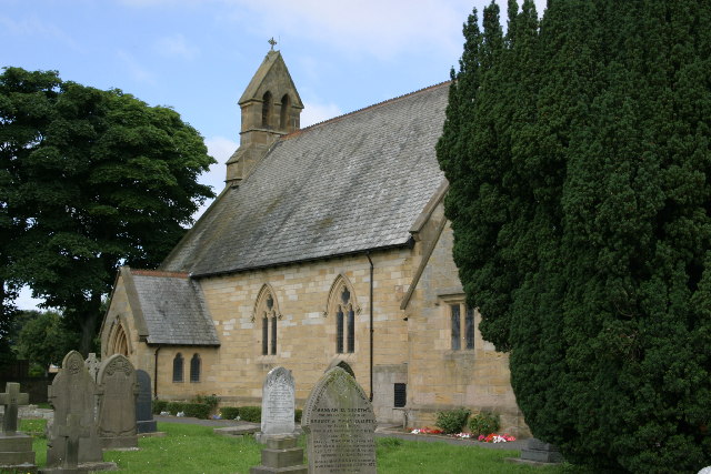

Dinnington, United Kingdom
Dinnington is a town of 1,483 people in England, United Kingdom.
Why visit Dinnington
Townapedia lists 3 museums and landmarks, 21 parks and trails, 29 places to eat, 9 places to stay and 3 attractions in and around town.
Highlights include Jubilee Theatre, Regent Centre and Big Waters.
Weather in Dinnington
Forecast from MET Norway (CC BY 4.0). Full forecast
About Dinnington
Dinnington is a village and civil parish in the city of Newcastle upon Tyne in Tyne and Wear, England. It is about 9 miles (14 km) north of the city centre, and about 5 miles (8.0 km) north-east of Newcastle International Airport. According to the 2011 Census, Dinnington Parish has 737 households and a population of 1,636; of whom 358 are 65 or over (almost 22%).
From the Wikipedia article Dinnington, Tyne and Wear (this version), under CC BY-SA 4.0.
Things to do3

Jubilee Theatre
Cinema and theater · 3.7 mi
Theatre in St Nicholas Hospital, Gosforth, Newcastle, England

The Blagdon Farm Shop
Farm and orchard · 1.8 mi
16-18 Milkhope Centre, Newcastle upon Tyne

Museums and landmarks3


Parks, trails and playgrounds21

Regent Centre
Park · 3.6 mi
Business park in Gosforth, Newcastle upon Tyne, England

Gosforth Central Park
Park · 4.0 mi
Park near to Gosforth High Street in Gosforth, Newcastle upon Tyne, England
Gosforth Park
Park · 3.0 mi
Park in North Gosforth, Tyne and Wear, England, UK


9 more on the map.
Restaurants and cafes29

Plaza Cafe and Bistro
Cafe · Breakfast, Burger, Coffee Shop, Local, Pasta, Pizza, Sandwich · 1.9 mi
Wagonway Drive, Newcastle upon Tyne
We-Th 09:00-20:00; Mo-Tu 09:00-16:00; Fr-Sa 09:00-22:00; Su 09:00-18:00



17 more on the map.
History
The village has been inhabited since before the Iron Age (700 BC). Mining has taken place from at least 1715, with the first deep mine being the Augusta Pit at Dinnington Colliery which was sunk in 1867. 1919 saw the formation of Dinnington Parish Council. In 1974 boundary changes led to the village, previously within Northumberland, being incorporated into the City of Newcastle upon Tyne.
Formerly a coal-mining village with at least four pits within two miles (3 km), Dinnington expanded during the last 40 years of the twentieth century to become a commuter or dormitory village with suburban residential estates and is set for further residential development. Two areas of Green Belt land have been removed to allow 250 private houses to be built and a further 160 have been constructed at Donkey Field.
On 1 April 1876, a 23-years-old miner, George Hunter, was hanged for murder at Morpeth Goal. In December 1875, Hunter and his victim, William Wood, who both worked at Dinnington Colliery, were in a group of armed miners intent on a shooting expedition. Following a snowball fight and altercation outside St Matthew's churchyard on Main Road, Dinnington, Hunter fired at Wood with a shotgun, killing him. He was found guilty of murder on 5 March 1876, the subsequent execution carried out by William Marwood. William Wood was buried at St Matthew's with an attendance of 1,500 people.
From the History section of Dinnington, Tyne and Wear on Wikipedia, under CC BY-SA 4.0.
More about Dinnington
Education
The local school, Dinnington First School has around 140-150 pupils and feeds into Gosforth East Middle School. A statutory notice was issued in October 2017 to increase pupil numbers at Dinnington First School from 150 to 300 pupil places by building a new school on the same Sycamore Avenue site. It is planned that the school will double its intake and admit up to 60 pupils into the reception class in September 2019. There will continue to be up to 52 part-time places in the nursery class.
From the Wikipedia article Dinnington, Tyne and Wear, under CC BY-SA 4.0.
Where to stay9
DoubleTree by Hilton Newcastle International Airport
Motel and hotel · 1.9 mi
Woolsington, Newcastle upon Tyne
Churches and places of worship6
Shopping5
Gas and EV charging3
Schools, colleges and libraries9
Healthcare2
Map of Dinnington
90 places. The map loads OpenStreetMap tiles when you open it.
Getting there and nearby towns
Newcastle International Airport (NCL) is the nearest airport with scheduled flights listed in OpenStreetMap, 1 miles away.
- Hazlerigg 2 mi southeast, about 3 min by car
- Ponteland 3 mi west, about 4 min by car
- Cramlington 4 mi northeast, about 7 min by car
- Gosforth 4 mi southeast, about 7 min by car
- Newburn 5 mi southwest, about 9 min by car
- Newcastle upon Tyne 6 mi southeast, about 10 min by car
- Bedlington 6 mi northeast, about 10 min by car
- Blaydon-on-Tyne 6 mi south, about 10 min by car
- Gateshead 7 mi southeast, about 11 min by car
- Wallsend 7 mi southeast, about 11 min by car
Drive times are estimates from straight-line distance, not routes.
Towns near Dinnington


Keep exploring
Local news
Headlines from INDB.
Reviews, tips and questions
Loading what members have shared...
Sources and licences
- GeoNames (CC BY 4.0): population, coordinates, regions and time zone
- Mapillary (see each image): photos
- OpenStreetMap contributors (ODbL 1.0): places, airports, map data
- Wikidata (CC0 1.0): elevation, founding date, time zone, website, landmarks and historic places
- Wikimedia Commons (see each image): photos
- Wikipedia (CC BY-SA 4.0): overview and history text
Photo credits
- Regent Centre, Gosforth and surrounding area, 1978 (26518989955), Tyne & Wear Archives & Museums, No restrictions
- Church of All Saints, Gosforth, Newcastle-upon-Tyne, Dave Kelly, CC BY-SA 2.0
- Dinnington - Saint Michael's Church, Phil Thirkell, CC BY-SA 2.0
- JubileeTheatre, Unknown author, CC BY 2.5
- Street-level photo, southglos, CC BY-SA 4.0
- Street-level photo, floatingboater, CC BY-SA 4.0
- Street-level photo, floatingboater, CC BY-SA 4.0
- Street-level photo, victuallers, CC BY-SA 4.0
- Street-level photo, southglos, CC BY-SA 4.0
- Street-level photo, floatingboater, CC BY-SA 4.0
Page built November 10, 2026. Spotted a mistake? Tell us or suggest a place.