
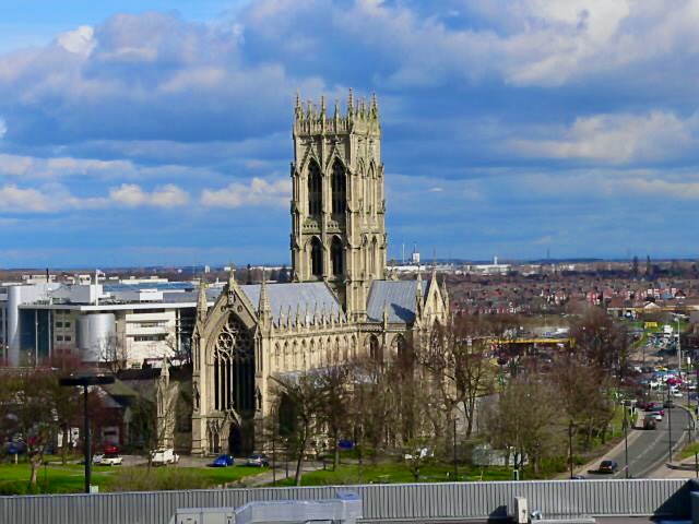


Doncaster, United Kingdom
Doncaster is a city of 113,566 people in England, United Kingdom.
Why visit Doncaster
Townapedia lists 20 museums and landmarks, 44 parks and trails, 215 places to eat, 20 places to stay and 7 attractions in and around town.
Highlights include Don Bridge, Grand Theatre, Danum Gallery, Library and Museum and Cusworth Hall.
Weather in Doncaster
Forecast from MET Norway (CC BY 4.0). Full forecast
About Doncaster
Doncaster is a city in South Yorkshire, England. Named after the River Don, it is the administrative centre of the City of Doncaster metropolitan borough, and is the second largest settlement in South Yorkshire after Sheffield. Noted for its racing and railway history, it is situated in the Don Valley on the western edge of the Humberhead Levels and east of the Pennines. It had a population of 87,455 at the 2021 census, whilst its built-up area had a population of 160,220, and the wider metropolitan borough had a population of 308,100.
From the Wikipedia article Doncaster (this version), under CC BY-SA 4.0.
Travel tips from other travellers: Doncaster on Wikivoyage (CC BY-SA 4.0).
Photos of Doncaster


Things to do7


Grand Theatre
Cinema and theater
Former theatre in Doncaster, England, later a bingo hall



Museums and landmarks20

Danum Gallery, Library and Museum
Museum
Museum in Doncaster, United Kingdom
Waterdale, Doncaster
Mo-Tu 11:00-17:00; We 09:30-16:30; Th 13:00-19:00; Fr-Sa...


Brodsworth Hall
Museum · 5.0 mi
Grade I listed historic house museum in Brodsworth, Doncaster, South Yorkshire, England, UK

Conisbrough Castle
Monument and historic site · 4.7 mi
Grade I listed historic house museum in Conisbrough, Doncaster, South Yorkshire, England, UK
Cusworth Hall and Park
Museum · 1.9 mi
Grade I listed historic house museum in Sprotbrough and Cusworth, Doncaster, South Yorkshire, England, UK

South Yorkshire Aircraft Museum
Museum · 1.1 mi
Aviation museum in Doncaster, South Yorkshire, United Kingdom


Kings Own Yorkshire Light Infantry Museum
Museum
Waterdale, Doncaster
Mo-Fr 10:00-17:00; Sa 10:00-16:00; Su off

8 more on the map.
Parks, trails and playgrounds44

Potteric Carr Nature Reserve
Hiking and trails · 2.4 mi
Nature reserve in South Yorkshire, England
Mo-Su 09:00-17:00


Thorpe Marsh Nature Reserve
Park · 3.9 mi
Nature reserve in South Yorkshire, England


Sandall Park
Park · 2.3 mi
Park in Doncaster, South Yorkshire, England
Town Fields
Park · 0.5 mi
Park in Doncaster, South Yorkshire, England


32 more on the map.
Restaurants and cafes215

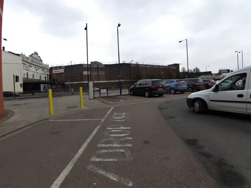

Bone Idle
Bar and pub · Coffee Shop
54 Silver Street, Doncaster
Mo 10:00-19:00; Tu-Th 10:00-21:00; Fr-Sa 10:00-23:00; Su 11:00-16:00

Caffè Nero
Cafe · Coffee Shop
41 St Sepulchre Gate, Doncaster
Mo-Fr 07:00-18:00; Sa 07:00-18:30; Su 08:30-17:00
Starbucks
Cafe · Coffee Shop · 0.4 mi
St Sepulchre Gate, Doncaster
Mo-Th 06:30-18:00; Fr,Sa 06:30-19:00; Su 09:00-17:00


203 more on the map.
History
Possibly inhabited earlier, Doncaster grew up on the site of a Roman fort of the 1st century CE, at a crossing of the River Don. The 2nd-century Antonine Itinerary and early-5th-century Notitia Dignitatum (Register of Dignitaries) called the fort Danum. The first section of road to the Doncaster fort had probably been built since the early 50s, while a route through the north Derbyshire hills was opened in the later 1st century, possibly by Governor Gn. Julius Agricola in the late 70s. Doncaster provided an alternative land route between Lincoln and York, while the main route Ermine Street involved parties breaking up to cross the Humber in boats. As this was not always practical, the Romans saw Doncaster as an important staging post. The Roman road appears on two routes recorded in the Antonine Itinerary. The itinerary includes the same section of road between Lincoln and York and lists three stations between these two coloniae. Routes 7 and 8 (Iter VII & VIII) are entitled "the route from York to London".
Read more of the history
Several areas of intense archaeological interest have been identified in the town, although many such as St Sepulchre Gate remain hidden under buildings. The Roman fort is thought to have lain on the site now taken by St George's Minster, beside the River Don. The Doncaster garrison units are named in a Register produced near the end of Roman rule in Britain: it was the home of the Crispinian Horse, presumably named after the tribes living near Crispiana in Pannonia Superior (near present-day Zirc in western Hungary), but possibly after Crispus, son of Constantine the Great, who was headquartered there while his father was based in nearby York. The Register names the unit as under the command of the "Duke of the Britons".
In 1971 the Danum shield, a rectangular Roman shield dating to the 1st or 2nd century CE, was recovered from the site of the Danum fort.
An inscribed altar, dedicated to the Matres by Marcus Nantonius Orbiotalus, was found at St Sepulchre Gate in 1781. This was donated to the Yorkshire Museum in 1856.
Doncaster is generally identified with Cair Daun listed as one of 28 British cities in the 9th-century History of the Britons traditionally ascribed to Nennius. It was certainly an Anglo-Saxon burh, and in that period received its present name: "Don-" (Old English: Donne) from the settlement and river and "-caster" (-ceaster) from an Old English version of the Latin castra (military camp; fort). It was mentioned in the 1003 will of Wulfric Spott. Shortly after the Norman Conquest, Nigel Fossard refortified the town and built Conisbrough Castle. By the time of Domesday Book, Hexthorpe in the wapentake of Strafforth was said to have a church and two mills. The historian David Hey says these facilities represent the settlement at Doncaster. He also suggests that the street name Frenchgate indicates that Fossard invited fellow Normans to trade in the town. Doncaster was ceded to Scotland in the Treaty of Durham and never formally returned to England.
With the 13th century, Doncaster matured into a busy town. In 1194 King Richard I granted it national recognition with a town charter. It suffered a disastrous fire in 1204, from which it slowly recovered. At the time, buildings were built of wood, and open fireplaces used for cooking and heating.
In 1248, a charter was granted for Doncaster Market to be held in the area surrounding the Church of St Mary Magdalene, which was built in Norman times. In the 16th century, the church was adapted for use as the town hall. It was finally demolished in 1846. Some 750 years on, the market continues to operate, with busy traders located under cover, at the 19th-century Doncaster Corn Exchange building (1873). The Corn Exchange was much rebuilt in 1994 after a major fire.
During the 14th century, numerous friars arrived in Doncaster who were known for their religious enthusiasm and preaching. In 1307 the Franciscan friars (Greyfriars) arrived, as did Carmelites (Whitefriars) in the mid-14th century. Other major medieval features included the Hospital of St Nicholas and the leper colony of the Hospital of St James, a moot hall, a grammar school and a five-arched stone town bridge with a chapel dedicated to Our Lady of the Bridge. By 1334, Doncaster was the wealthiest town in southern Yorkshire and the sixth in Yorkshire as a whole, even boasting its own banker. By 1379, it was recovering from the Black Death, which had reduced its population to 1,500. In October 1536, the Pilgrimage of Grace ended in Doncaster. This rebellion led by the lawyer Robert Aske commanded 40,000 Yorkshire people against Henry VIII, in protest at the Dissolution of the Monasteries. Many of Doncaster's streets are named with the suffix "-gate", after the old Danish word gata, meaning street. In medieval times, craftsmen or tradesmen with similar skills tended to live in the same street. Baxter is an ancient word for baker: Baxtergate was the bakers' street. Historians believe that Frenchgate may be named after French-speaking Normans who settled there.
The medieval township is known to have been protected by earthen ramparts and ditches, with four substantial gates as entrances to the town. These were located at Hall Gate, St Mary's Bridge (old), St Sepulchre Gate and Sunny Bar. Today the gates at Sunny Bar are commemorated by huge "Boar Gates"; similarly, the entrance to St Sepulchre Gate is commemorated by white marble "Roman Gates". The boundary of the town mainly extended from the Don along a route known now Market Road, Silver Street, Cleveland Street and Printing Office Street.
From the History section of Doncaster on Wikipedia, under CC BY-SA 4.0.
More about Doncaster
Geography
Doncaster is the second largest settlement in South Yorkshire and the largest metropolitan district in England by area. It expanded dramatically in population with the development of coal mining. Closure of coal mines in the 1970s and early 1980s caused economic difficulties; the town then developed its service industry, drawing on the good communication links with the rest of the UK.
The Doncaster skyline is overlooked by the minster in the middle of the city. The Frenchgate Shopping Centre is in a similar position in the skyline, along with the Doncaster College Hub building.
After the old Doncaster College and surrounding buildings were demolished, the new Doncaster Civic Office designed by Cartwright Pickard was built for the City of Doncaster Council at a cost of £20 million and completed in 2012.
Doncaster lies in a lowland valley in southern Yorkshire. To the west are low rolling hills eventually reaching the Pennines. To the east are the low-lying Isle of Axholme and Humberhead Levels. The south is relatively low-lying, with a large forested area including Sherwood Forest in Nottinghamshire. The Vale of York lies to the north. The floodplains of the River Don lie to Doncaster's north-east; this area is regularly flooded, notably in 2007 and 2019.
Economy
Doncaster emerged as an industrial centre in the late 18th to 20th centuries. Its communications, particularly its waterways, meant that it became extremely busy and experienced migration to its centre. Underneath Doncaster lies a huge natural resource by way of deep seam coal.
Doncaster's proximity to major urban centres and motorway/rail infrastructure gives it a number of major distribution centres, including the 420-acre Doncaster International Railport, which dispatches goods to Europe. It also has large warehousing and logistic capabilities for retailers such as Next, Tesco, IKEA, Amazon.com, Lidl and Faberge. A marked proportion of fresh and frozen goods for northern supermarkets is dispatched by road from Doncaster.
On 5 March 2004, Doncaster was granted Fairtrade Town status. Over the last few years the Doncaster Lakeside, as home to the Doncaster Rovers ground, has undergone modernisation. Doncaster has a bowling alley and a cinema near Lakeside. The Dome, opened in 1989 by Princess Diana, contains a swimming pool, gym, ice rink and café.
The Frenchgate Centre is a shopping centre and transport interchange. Opened in June 2006, it connects with the railway and bus stations.
Arts and culture
Doncaster Museum and Art Gallery opened as the town's main museum in 1964. It covers natural history, archaeology, local history and fine and decorative art. It has a major exhibition of silverware and trophies won at Doncaster Racecourse. It also houses the Regimental Museum of the King's Own Yorkshire Light Infantry. Doncaster is home to Yorkshire Wildlife Park, which has over 400 animals and over 70 different species, including the only polar bears in England.
The South Yorkshire Aircraft Museum (formerly Aero Venture) is based on the old site of RAF Doncaster at Doncaster Lakeside. The Trolleybus Museum in the nearby village of Sandtoft specialises in preserving trolleybuses, and claims to have the largest collection of them in Europe, with over 60 examples. Markham Grange Steam Museum, in a garden centre in the nearby village of Brodsworth, has a private collection of steam engines. Ashworth Barracks Museum is a military museum in Balby telling the story of the men awarded the Victoria Cross. It also houses a First World War exhibit including a "Weekers Helmet", one of only two known that exist in the UK.
From the Wikipedia article Doncaster, under CC BY-SA 4.0.
Notable people from Doncaster
 John McLaughlinEnglish guitarist, founder of the Mahavishnu OrchestraPhoto: Hantsheroes, CC0
 YungbludBritish musician (born 1997)Photo: Toglenn, CC BY-SA 4.0
 Ron FlowersEnglish footballer and manager (1934-2021)Photo: Hugo van Gelderen / Anefo, CC0
 Ethel TurnerAustralian writer (1872–1958)Photo: Harold Cazneaux, Public domain
 Ben TurnerBritish bicycle racerPhoto: Cs-wolves, CC BY-SA 4.0
 Mark RyanEnglish actor, author and action directorPhoto: Hexcon77, CC BY-SA 4.0
 Philip DaviesBritish Conservative politician (born 1972)Photo: Chris McAndrew, CC BY 3.0
 Charles SaundersBritish politician and naval officer (1715–1775)Photo: Joshua Reynolds, Public domain
- Diana RiggEnglish actress (1938–2020)
- Danny RoseEnglish footballer (born 1990)
- Emma ChambersEnglish actress (1964–2018)
- Sarah StevensonBritish taekwondo athlete
Born in Doncaster, according to Wikidata (CC0). Each name links to its Wikipedia article.
Where to stay20
Doncaster International Hotel
Motel and hotel · 1.4 mi
Decoy Bank South, Doncaster
Churches and places of worship60
Priory Place Methodist Church
Church · Methodist
Printing Office Street, Doncaster
Shopping52
Gas and EV charging19
Schools, colleges and libraries74
Our Lady of Mount Carmel Catholic Primary School
School · Roman Catholic · 1.5 mi
Sandringham Road, Doncaster
Our Lady of Perpetual Help Catholic Primary School
School · Roman Catholic · 1.8 mi
Finkle Street, Doncaster
Healthcare13
Sprotbrough Village Pharmacy
Clinic and pharmacy · 2.5 mi
14 Main Street, Doncaster
Map of Doncaster
250 places. The map loads OpenStreetMap tiles when you open it.
Getting there and nearby towns
Humberside Airport (HUY) is the nearest airport with scheduled flights listed in OpenStreetMap, 32 miles away.
- Rotherham 11 mi southwest, about 18 min by car
- Sheffield 17 mi southwest, about 27 min by car
- Wakefield 19 mi northwest, about 30 min by car
- Leeds 25 mi northwest, about 41 min by car
- Mansfield 27 mi south, about 44 min by car
- Huddersfield 28 mi west, about 45 min by car
- York 30 mi north, about 48 min by car
- Lincoln 32 mi southeast, about 51 min by car
- Kingston upon Hull 36 mi northeast, about 58 min by car
- Nottingham 39 mi south, about 1 h by car
Drive times are estimates from straight-line distance, not routes.
Towns near Doncaster


Keep exploring
Local news
Headlines from INDB.
Reviews, tips and questions
Loading what members have shared...
Sources and licences
- GeoNames (CC BY 4.0): population, coordinates, regions and time zone
- Mapillary (see each image): photos
- OpenStreetMap contributors (ODbL 1.0): places, airports, map data
- Wikidata (CC0 1.0): elevation, founding date, time zone, website, landmarks and historic places
- Wikimedia Commons (see each image): photos
- Wikipedia (CC BY-SA 4.0): overview and history text
Photo credits
- Doncaster Skyline, Harleyamber ( talk ), CC BY 3.0
- K6 Telephone Box Hall Gate Doncaster, Peter Broster, CC BY-SA 4.0
- K6 Telephone Box High St Doncaster, Peter Broster, CC BY-SA 4.0
- A1 Bridge over R Don - panoramio, PJMarriott, CC BY 3.0
- Doncaster Museum, Marasmusine (Janine Timiney), Public domain
- ConisbroughCastle, Rob Bendall ( Highfields ), Attribution
- Potteric Carr Bridges over Mother Drain, Dave Taylor, CC BY-SA 2.0
- Main Embankment at NMH (Thorpe Marsh Nature Reserve), NJLE17, CC BY-SA 4.0
- Cusworth Hall 1, Foto43, CC BY 2.0
- St Georges Doncaster, Frees, CC BY 3.0
- Keepmoat Stadium Doncaster, Frees, CC BY 3.0
- Doncaster Mansion House, Warofdreams, CC BY-SA 3.0
- The Boat Inn, Sprotbrough, Ian S, CC BY-SA 2.0
- Armthorpe - Saint Mary and Saint Leonartd's Church, Richard Croft, CC BY-SA 2.0
- Doncaster Minster Aerial, 1128jamie, CC BY 4.0
- Doncaster Grand Theatre, Warofdreams, CC BY-SA 4.0
- Lamp Standard To Front Of Hall Gate United Reformed Church, Peter Glyn, CC BY-SA 3.0
- Westminster Building (1), Peter Glyn, CC BY-SA 3.0
- Cast British Railways crest from AC Electric locomotive, kitmasterbloke, CC BY 2.0
- Brodsworth Hall - panoramio - PJMarriott (1), PJMarriott, CC BY 3.0
- Reims F150G G-AVAA at South Yorkshire Aircraft Museum 2020-08-07 (50365239067), Alan Wilson from Peterborough, Cambs, UK, CC BY-SA 2.0
- Yorkshire Wildlife Park - Baboon Reserve, Graham Hogg, CC BY-SA 2.0
- Street-level photo, victuallers, CC BY-SA 4.0
- Street-level photo, victuallers, CC BY-SA 4.0
- Street-level photo, cuttlebug, CC BY-SA 4.0
- Street-level photo, victuallers, CC BY-SA 4.0
- Street-level photo, cuttlebug, CC BY-SA 4.0
- Street-level photo, smsm1, CC BY-SA 4.0
- Street-level photo, victuallers, CC BY-SA 4.0


Page built November 10, 2026. Spotted a mistake? Tell us or suggest a place.