
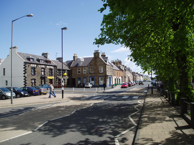


Earlston, United Kingdom
Earlston is a town of 1,780 people in Scotland, United Kingdom.
Why visit Earlston
Townapedia lists 10 museums and landmarks, 8 places to eat, 1 place to stay and 5 attractions in and around town.
Highlights include Old Bridge, Drygrange, Scott's View, Melrose Abbey and Trimontium.
Weather in Earlston
Forecast from MET Norway (CC BY 4.0). Full forecast
About Earlston
Earlston (Scottish Gaelic: Dùn Airchill) is a historic market town and civil parish in the Scottish Borders, Scotland. Historically part of the county of Berwickshire, the town lies on the River Leader in Lauderdale, and is approximately 29 miles (47 km) south-southeast of Edinburgh, 63 miles (102 km) east-southeast of Glasgow, and 58 miles (96 km) south-southeast of Perth. It had a population of 1,765 in 2022.
From the Wikipedia article Earlston (this version), under CC BY-SA 4.0.
Photos of Earlston

Things to do5
Old Bridge, Drygrange
Bridge · 2.4 mi
Road bridge in Scottish Borders

Scott's View
Monument and historic site · 2.9 mi
Scenic viewpoint in Scottish Borders, Scotland, UK

Museums and landmarks10

Melrose Abbey
Monument and historic site · 3.2 mi
Partly ruined monastery in Melrose, Scotland

Trimontium
Monument and historic site · 2.6 mi
Archaeological site in Scottish Borders, Scotland, UK



Restaurants and cafes8
With a cherry on top
Ice cream
High Street, Earlston
Mo-Su 11:00-19:00
Alfonso's Fish & Chips
Fast food · Fish And Chips
High Street, Earlston
Mo-Th 12:00-14:00, Su-Th 16:00-23:00, Fr,Sa 16:00-23:30

Priya Fine Indian Cuisine
Restaurant · Indian, Takeway Only (No Delivery)
Turfford Park, Earlston
We-Fr 12:00-19:30

Where to stay1
More about Earlston
Education
Earlston Primary School educates pupils from a number of surrounding villages and hamlets.
Earlston is also served by Earlston High School, an S1 - S6 secondary school. It also takes pupils from the surrounding area. The present school building located at Georgefield opened in the summer of 2009. The old building was in an area beside the industrial estate and attached to the primary school.
From the Wikipedia article Earlston, under CC BY-SA 4.0.
Notable people from Earlston
- Thomas the Rhymer13th-century Scottish laird and reputed prophet from Earlston
- John RedpathCanadian businessman
- Charles GordonBritish army officer
- Robert CarterAmerican publisher (1807-1889)
- James ScottScottish-Tasmanian politician and surveyor
Born in Earlston, according to Wikidata (CC0). Each name links to its Wikipedia article.
Churches and places of worship2
Shopping1
Gas and EV charging1
Schools, colleges and libraries3
Healthcare2
Map of Earlston
33 places. The map loads OpenStreetMap tiles when you open it.
Getting there and nearby towns
Edinburgh Airport (EDI) is the nearest airport with scheduled flights listed in OpenStreetMap, 34 miles away.
- Melrose 3 mi southwest, about 5 min by car
- Newtown St Boswells 4 mi south, about 7 min by car
- Saint Boswells 5 mi south, about 8 min by car
- Galashiels 5 mi west, about 9 min by car
- Selkirk 9 mi southwest, about 14 min by car
- Kelso 10 mi east, about 16 min by car
- Jedburgh 12 mi southeast, about 19 min by car
- Innerleithen 15 mi west, about 24 min by car
- Hawick 16 mi south, about 25 min by car
- Peebles 20 mi west, about 32 min by car
Drive times are estimates from straight-line distance, not routes.
Towns near Earlston


Keep exploring
Local news
Headlines from INDB.
Reviews, tips and questions
Loading what members have shared...
Sources and licences
- GeoNames (CC BY 4.0): population, coordinates, regions and time zone
- Mapillary (see each image): photos
- OpenStreetMap contributors (ODbL 1.0): places, airports, map data
- Wikidata (CC0 1.0): elevation, founding date, time zone, website, landmarks and historic places
- Wikimedia Commons (see each image): photos
- Wikipedia (CC BY-SA 4.0): overview and history text
Photo credits
- Main Street, Earlston, Kevin Rae, CC BY-SA 2.0
- 10132 Former East United Presbyterian Church, Earlston 002, WeeHolly, CC BY-SA 4.0
- 10132 Former East United Presbyterian Church, Earlston 004, WeeHolly, CC BY-SA 4.0
- 10132 Former East United Presbyterian Church, Earlston 003, WeeHolly, CC BY-SA 4.0
- 10132 Former East United Presbyterian Church, Earlston 001, WeeHolly, CC BY-SA 4.0
- 06642 St Cuthbert's Roman Catholic Hall-Church, Earlston 001, WeeHolly, CC BY-SA 4.0
- War memorial in Earlston, Victuallers, CC BY-SA 3.0
- Scottsview3.1, Ruy Lestrade (www.flickr.com/semi-detached), CC BY-SA 3.0
- +1136 wurde Das Zisterienserkloster Melrose gegründet. 03, Holger Uwe Schmitt, CC BY-SA 4.0
- Trimontium, Unknown author, CC BY-SA 2.0 de
- Legerwood Kirk, Jimmydenham ( talk ), Public domain
- EHS Front (cropped), Theborderer, CC0
- Sixth report and inventory of monuments and constructions in the county of Berwick (1915) (14801728893), Scotland. Royal Commission on the Ancient and Historical Monuments and Constructions, No restrictions
- Earlston, Earlston War Memorial, Victuallers, CC BY-SA 4.0
- Street-level photo, southglos, CC BY-SA 4.0
- Street-level photo, victuallers, CC BY-SA 4.0
- Street-level photo, victuallers, CC BY-SA 4.0
- Street-level photo, victuallers, CC BY-SA 4.0
- Street-level photo, victuallers, CC BY-SA 4.0
- Street-level photo, victuallers, CC BY-SA 4.0
- Street-level photo, victuallers, CC BY-SA 4.0
- Street-level photo, victuallers, CC BY-SA 4.0
- Street-level photo, victuallers, CC BY-SA 4.0
- Street-level photo, victuallers, CC BY-SA 4.0
- Street-level photo, southglos, CC BY-SA 4.0


Page built November 10, 2026. Spotted a mistake? Tell us or suggest a place.