
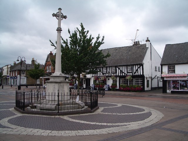


Hoddesdon, United Kingdom
Hoddesdon is a town of 35,174 people in England, United Kingdom.
Why visit Hoddesdon
Townapedia lists 8 museums and landmarks, 17 parks and trails, 87 places to eat, 4 places to stay and 2 attractions in and around town.
Highlights include Spotlight Theatre, Lowewood Museum, Rye House Gatehouse and Barclay Park.
Weather in Hoddesdon
Forecast from MET Norway (CC BY 4.0). Full forecast
About Hoddesdon
Hoddesdon is a town in the Borough of Broxbourne, Hertfordshire, lying entirely within the London Metropolitan Area and Greater London Urban Area. The area is on the River Lea and the Lee Navigation along with the New River.
From the Wikipedia article Hoddesdon (this version), under CC BY-SA 4.0.
Photos of Hoddesdon


Things to do2

Museums and landmarks8

Lowewood Museum
Museum · 0.4 mi
High Street, Hoddesdon
We-Fr 10:00-16:00; Sa 10:00-17:00



Parks, trails and playgrounds17


King's Meads
Park · 3.3 mi
Nature reserve in Ware, Hertfordshire, United Kingdom




5 more on the map.
Restaurants and cafes87



75 more on the map.
History
The name "Hoddesdon" is believed to be derived from a Saxon or Danish personal name combined with the Old English suffix "don", meaning a down or hill. The earliest historical reference to the name is in the Domesday Book within the hundred of Hertford.
Hoddesdon was situated about 20 miles (32 km) north of London on the main road to Cambridge and to the north. The road forked in the centre of the town, with the present High Street dividing into Amwell Street and Burford Street, both leading north to Ware. From an early date there were a large number of inns lining the streets to serve the needs of travellers. A market charter was granted to Robert Boxe, lord of the manor, in 1253. By the 14th century the Hospital of St Laud and St Anthony had been established in the south of Hoddesdon. The institution survived the dissolution of the monasteries, but had ceased to exist by the mid 16th century, although it is commemorated in the name of Spital Brook which divides Hoddesdon from Broxbourne.
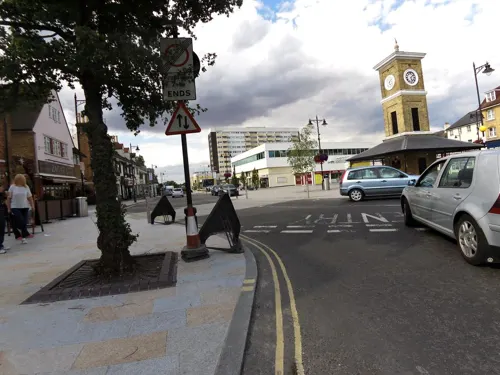
In 1336 William de la Marche was licensed to build a chapel of ease in the town. The building, known as St Katharine's Chapel, was used by pilgrims to the shrine at Walsingham. It survived until the 17th century, when it was demolished. In 1835, a single-storey building, known as Hoddesdon Town Hall, was built on the site: only the clock tower now survives.
Read more of the history
The town was considerably enlarged in the reign of Elizabeth I, and a number of inns in the High Street date from this time. The monarch granted a royal charter in 1559/60, placing the town government under a bailiff, warden and eight assistants. The charter also established a free grammar school based on the site of the former hospital, and this was placed under the care of the corporation. Neither the borough nor the school flourished, however, and both had ceased to exist by the end of the century. In 1567 Sir William Cecil acquired the manor of Hoddesdonsbury and two years later Elizabeth granted him the neighbouring manor of Baas. From that date the Cecils maintained a connection with the town which is recorded by the naming of The Salisbury Arms (anciently the Black Lion Inn) : the title Marquess of Salisbury was granted to James Cecil in 1789.
In 1622 Sir Marmaduke Rawdon built Rawdon House, a red-brick mansion which still survives. Rawdon also provided the town with its first public water supply, flowing from a statue known as the "Samaritan Woman".
In 1683 there was an alleged Whig conspiracy to assassinate or mount an insurrection against Charles II of England because of his pro-Roman Catholic policies. This plot was known as the Rye House Plot, named from Rye House at Hoddesdon, near which ran a narrow road where Charles was supposed to be killed as he travelled from a horse meeting at Newmarket. By chance, according to the official narrative, the king's unexpectedly early departure in March foiled the plot. Ten weeks later, on 1 June, an informer's allegations prompted a government investigation.
The subsequent history of Rye House has been considerably less dramatic. In 1870 the current owner, William Henry Teale, opened a pleasure garden, displaying the Great Bed of Ware, which he had recently acquired. It was such a popular destination for excursions from London that an extra station was built on the Liverpool Street to Hertford East line to serve it.
By the early 20th century, however, the tourist trade had fallen off, and Rye House was demolished, apart from the Gatehouse; the Great Bed was moved to the Victoria & Albert Museum.
Rye House Gatehouse still stands today, and is now a Grade I listed building. It is open to the public at weekends and bank holidays during the summer, featuring displays about the Plot and the early history of brick-building. The rest of the grass-covered site has the floor-plan of the house marked out.
A new chapel of ease, dedicated to St Paul, was built in 1732. This was subsequently enlarged, and in 1844 become the parish church when Hoddesdon was created a separate ecclesiastical parish. Previously the town had been divided between the two parishes of Broxbourne and Great Amwell. The boundary between the two parishes ran through an archway in the town's High Street. When this building was demolished in the 1960s, a specially inscribed stone was set into the pavement marking the historic boundary.
Brewing was first established in the town in about 1700. In 1803, William Christie established a brewery in the town, and it became a major employer and one of the largest breweries in England. The brewery continued in operation until 1928. Most of the brewery buildings were demolished in 1930, although part was converted into a cinema itself since demolished. Some remnants of the establishment remain in Brewery Road.
By the mid-19th century the town still consisted principally of one street, and had a population of 1,743. Malt was being produced and transported to London via the River Lea. There were also a number of flour mills. Trade in Hoddesdon was centred on the hops market each Thursday. As time went on, more and more hops were carried on the river rather than the roads and the Wednesday meat market took predominance. The Wednesday market has survived and a Friday market was added in the late 20th century.
After the Second World War Hoddesdon increasingly became a dormitory town, forming part of the London commuter belt. Much of the town centre was demolished in the 1960s and 1970s, with the construction of the Tower Centre and Fawkon Walk shopping centres. The opening of a bypass in 1974 changed the nature of the town, with through traffic curtailed.
From the History section of Hoddesdon on Wikipedia, under CC BY-SA 4.0.
More about Hoddesdon
Education
The John Warner School is a community, foundation comprehensive for 11- to 18-year-olds.
Sheredes School served the area from 1969. In 2012 Sheredes received the artsmark gold award in recognition of the outstanding work in the arts and was one of only a handful of schools nationally to have been awarded this for a fourth time. In 2016 Sheredes became Robert Barclay Academy, a comprehensive school for 11- to 18-year-olds. John Warner has specialist status in science and sport and Sheredes was well regarded in the arts.
In 2007 the John Warner School received congratulations from Mr Jim Knight, Minister of State for Education for being placed 24th in the '100 most improved schools in the country'. This award is a combination of eight years continuous improvement in examination results.
From the Wikipedia article Hoddesdon, under CC BY-SA 4.0.
Notable people from Hoddesdon
 Lucy CharlesBritish triathletePhoto: Jürgen Matern, CC BY-SA 4.0
 Luke HinesBritish racing driverPhoto: United Autosports, CC BY-SA 2.0
 Mike BroadbankBritish speedway riderPhoto: Lawson Speedway, CC BY-SA 4.0
- Benjamin Samuel WilliamsEnglish orchidologist and nurseryman in London (1824-1890)
- Miles ReidMathematician researching Algebraic Geometry
- William GosseAustralian explorer (1842-1881)
- Lilian FaithfullEnglish educator and hockey player (1865-1952)
- Pete SullivanEnglish actor
- Hugh PaddickComedy actor (1915-2000)
- Herbert HamptonBritish sculptor (1862-1929)
- Harry Cliftonsinger and songwriter (1832–1872)
- Colin PrattEnglish speedway rider, promoter and team manager
Born in Hoddesdon, according to Wikidata (CC0). Each name links to its Wikipedia article.
Where to stay4
Churches and places of worship14
Broxbourne Parish Church (St Augustine's)
Church · Anglican · 1.2 mi
Hoddesdon Methodist Church
Church · Methodist · 0.5 mi
Middlefield Road, Hoddesdon
Kingdom Hall of Jehovahs Witnesses
Church · Jehovahs Witness
Charlton Close, Hoddesdon
Shopping10
Gas and EV charging3
Schools, colleges and libraries15
Healthcare7
Map of Hoddesdon
167 places. The map loads OpenStreetMap tiles when you open it.
Getting there and nearby towns
London Stansted Airport (STN) is the nearest airport with scheduled flights listed in OpenStreetMap, 14 miles away.
- Broxbourne 1 mi south, about 2 min by car
- Ware 3 mi north, about 6 min by car
- Hertford 4 mi northwest, about 6 min by car
- Waltham Abbey 5 mi south, about 8 min by car
- Waltham Cross 5 mi south, about 9 min by car
- Enfield Lock 6 mi south, about 10 min by car
- Epping 7 mi southeast, about 11 min by car
- Enfield Town 8 mi southwest, about 13 min by car
- Ponders End 8 mi south, about 13 min by car
- Welwyn Garden City 9 mi west, about 14 min by car
Drive times are estimates from straight-line distance, not routes.
Towns near Hoddesdon


Keep exploring
Local news
Headlines from INDB.
Reviews, tips and questions
Loading what members have shared...
Sources and licences
- GeoNames (CC BY 4.0): population, coordinates, regions and time zone
- Mapillary (see each image): photos
- OpenStreetMap contributors (ODbL 1.0): places, airports, map data
- Wikidata (CC0 1.0): elevation, founding date, time zone, website, landmarks and historic places
- Wikimedia Commons (see each image): photos
- Wikipedia (CC BY-SA 4.0): overview and history text
Photo credits
- HoddesdonTownCentre, Chris Hunt, CC BY-SA 2.0
- Clock Tower, High Street, Hoddesdon (21272353179), Peter O'Connor aka anemoneprojectors, CC BY-SA 2.0
- The Star, 105 High Street, Hoddesdon (20863976703), Peter O'Connor aka anemoneprojectors, CC BY-SA 2.0
- Hoddesdon Clock Tower Plaque (21467828951), Peter O'Connor aka anemoneprojectors, CC BY-SA 2.0
- Hoddesdon Clock Tower, Stefan Wolmarans, CC BY-SA 4.0
- Hoddesdon war memorial (21485067735), Peter O'Connor aka anemoneprojectors, CC BY-SA 2.0
- The White Swan, 95 High Street, Hoddesdon (21493683541), Peter O'Connor aka anemoneprojectors, CC BY-SA 2.0
- 109–111 High Street, Hoddesdon (21271428448), Peter O'Connor aka anemoneprojectors, CC BY-SA 2.0
- 120–122 High Street, Hoddesdon (21459242795), Peter O'Connor aka anemoneprojectors, CC BY-SA 2.0
- 118 High Street, Hoddesdon (21272350269), Peter O'Connor aka anemoneprojectors, CC BY-SA 2.0
- 116 High Street, Hoddesdon (21485072265), Peter O'Connor aka anemoneprojectors, CC BY-SA 2.0
- 93 High Street, Hoddesdon (21405644686), Peter O'Connor aka anemoneprojectors, CC BY-SA 2.0
- 91 High Street, Hoddesdon (21297251018), Peter O'Connor aka anemoneprojectors, CC BY-SA 2.0
- Hoddesdon High Street, Bull Hotel and cattle market, circa 1900(?), Squarewheels-wiki, CC BY-SA 4.0
- 100 High Street, Hoddesdon (21440330181), Peter O'Connor aka anemoneprojectors, CC BY-SA 2.0
- 87 and 89 High Street, Hoddesdon (21243812510), Peter O'Connor aka anemoneprojectors, CC BY-SA 2.0
- Shelter on High Street, Hoddesdon (20883764644), Peter O'Connor aka anemoneprojectors, CC BY-SA 2.0
- 79 and 81 High Street, Hoddesdon (21244975029), Peter O'Connor aka anemoneprojectors, CC BY-SA 2.0
- 90 High Street, Hoddesdon (21431872775), Peter O'Connor aka anemoneprojectors, CC BY-SA 2.0
- 88 High Street, Hoddesdon (21393700562), Peter O'Connor aka anemoneprojectors, CC BY-SA 2.0
- 78 High Street, Hoddesdon (21319624119), Peter O'Connor aka anemoneprojectors, CC BY-SA 2.0
- 78 High Street, Hoddesdon (21393698822), Peter O'Connor aka anemoneprojectors, CC BY-SA 2.0
- Amwell Quarry 16, Dudley Miles, CC BY-SA 4.0
- Hertford Heath north 9, Dudley Miles, CC BY-SA 4.0
- Ailurus fulgens -Paradise Wildlife Park, Hertfordshire, England-8a, William Warby from London, England, CC BY 2.0
- Nazeing Triangle 6, Dudley Miles, CC BY-SA 4.0
- 2022-01-29 St Augustine's Church, Broxbourne, The wub, CC BY-SA 4.0
- Aythya fuligula (5800456581), Tim Felce (Airwolfhound), CC BY-SA 2.0
- Lowewood museum front exterior, Geni, CC BY-SA 4.0
- Balls Wood 8, Dudley Miles, CC BY-SA 4.0
- Danemead 5, Dudley Miles, CC BY-SA 4.0
- 2022-01-29 Remains Of Window And Wall Near Inner Edge Of Moat West Of Rye House Gatehouse, The wub, CC BY-SA 4.0
- GOC Hoddesdon 064 Hoddesdon Lodge, Hoddesdon (29364283821), Peter O'Connor aka anemoneprojectors, CC BY-SA 2.0
- GOC Hoddesdon 006 Barclay Park, Hoddesdon (29176082382), Peter O'Connor aka anemoneprojectors, CC BY-SA 2.0
- Hunsdon Mead meadow in Hertfordshire, England, Glyn Baker, CC BY-SA 2.0
- King's Meads, Ware (51134249639), Peter O'Connor aka anemoneprojectors, CC BY-SA 2.0
- Street-level photo, smsm1, CC BY-SA 4.0
- Street-level photo, smsm1, CC BY-SA 4.0
- Street-level photo, smsm1, CC BY-SA 4.0
- Street-level photo, smsm1, CC BY-SA 4.0
- Street-level photo, smsm1, CC BY-SA 4.0
- Street-level photo, smsm1, CC BY-SA 4.0
- Street-level photo, smsm1, CC BY-SA 4.0
- Street-level photo, smsm1, CC BY-SA 4.0
- Street-level photo, smsm1, CC BY-SA 4.0
- Street-level photo, smsm1, CC BY-SA 4.0
- Street-level photo, smsm1, CC BY-SA 4.0
- Street-level photo, smsm1, CC BY-SA 4.0
- Street-level photo, smsm1, CC BY-SA 4.0
- Street-level photo, smsm1, CC BY-SA 4.0
- Street-level photo, smsm1, CC BY-SA 4.0
- Street-level photo, cyclestreets, CC BY-SA 4.0
- Street-level photo, wasd42, CC BY-SA 4.0
- Street-level photo, wasd42, CC BY-SA 4.0


Page built November 10, 2026. Spotted a mistake? Tell us or suggest a place.