


Hertford, United Kingdom
Hertford is a town of 25,847 people in England, United Kingdom, founded in 912.
Why visit Hertford
Townapedia lists 15 museums and landmarks, 18 parks and trails, 96 places to eat, 6 places to stay and 5 attractions in and around town.
Highlights include Hertford Theatre, Kingsmead Viaduct, Hertford Museum and Hertingfordbury.
Weather in Hertford
Forecast from MET Norway (CC BY 4.0). Full forecast
About Hertford
Hertford is a market town and civil parish in the East Hertfordshire district of the county of Hertfordshire, England. It is the county town of Hertfordshire and lies 20 miles (32 km) north of Charing Cross in Central London. At the 2021 census the parish had a population of 29,418 and the built up area had a population of 28,800.
From the Wikipedia article Hertford (this version), under CC BY-SA 4.0.
Travel tips from other travellers: Hertford on Wikivoyage (CC BY-SA 4.0).
Photos of Hertford


Things to do5



Museums and landmarks15

Hertford Museum
Museum
Local museum in Hertford, Hertfordshire, England, United Kingdom
18 Bull Plain, Hertford
Tu-Sa 10:00-17:00; Su 12:00-16:00

Hertingfordbury
Monument and historic site · 1.1 mi
Closed in 1962, the platform and station building can still be seen, now a private residence




Hertingfordbury House
Monument and historic site · 0.9 mi
St Mary's Lane, Hertford
3 more on the map.
Parks, trails and playgrounds18






6 more on the map.
Restaurants and cafes96


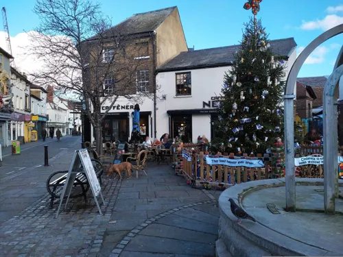
Caffè Nero
Cafe · Coffee Shop
2-4 Salisbury Square, Hertford
Mo-Fr 07:00-18:30,Sa 07:30-18:00,Su 08:00-18:00



Veg Heads
Cafe · Burger · 0.5 mi
45 Ware Road, Hertford
Mo-Th 12:00-20:00; Fr-Sa 12:00-21:00; Su 12:00-17:30

84 more on the map.
History
One possible earlier mention of the town was in 672 AD: the first synod of a number of the bishops in England was held either in Hertford or at Hartford, Cambridgeshire. The synod was called by Theodore of Tarsus; decisions included the calculation of the date of Easter.
The Anglo-Saxon Chronicle records that in 913 AD, Edward the Elder ordered the construction of two burhs (earthwork fortifications) either side of the ford over the River Lea at Hertford as part of his campaign against the Danes.
By the time of the Domesday Book, Hertford had two churches, two markets and three mills. The Normans began work on Hertford Castle, and Hertford Priory was founded by Ralph de Limesy. King Henry II rebuilt the castle in stone, but in 1216, during the First Barons' War, it was besieged and captured after 25 days by Prince Louis of France. The castle was regularly visited by English royalty and in 1358, Queen Isabella, wife of Edward II, died there. The priory was dissolved in 1536 and subsequently demolished. In 1563, the Parliament of England met at the castle because of an outbreak of plague in London.
Hertford grew and prospered as a market and county town; communication was improved by the construction of the Lea Navigation Canal in 1767 and the arrival of the railway in 1843. The Port Hill drill hall was completed in 1898 and Yeomanry House was brought into military use in 1910.
Read more of the history
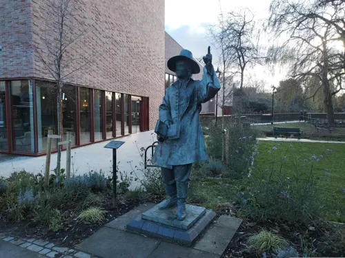
Samuel Stone was born in Fore Street, Hertford in 1602. He became a Puritan minister and emigrated to America, where he settled at a Native American community called Saukiog in Connecticut. He was instrumental in developing the community into a city, renaming it Hartford in 1637, after his birthplace. A statue of Samuel Stone was erected in The Wash in the centre of Hertford in 1999.
From the History section of Hertford on Wikipedia, under CC BY-SA 4.0.
More about Hertford
Geography
Hertford is at the confluence of four river valleys: the Rib, Beane and Mimram join the River Lea at Hertford to flow east and then south toward the Thames as the Lee Navigation, after Hertford Castle Weir. The shared valley of the Lea and the Beane is called Hartham Common and this provides a large park to one side of the town centre running towards Ware and lying below the ridge upon which Bengeo is situated.
The town centre still has its medieval layout with many timber-framed buildings hidden under later frontages, particularly in St Andrew Street. Hertford suffers from traffic problems caused by the existence of the 1960s A414 dual carriageway called Gascoyne Way which carved through the town, destroying many historic buildings in its path and cutting off the southern part of the town from the northern part. Plans have long existed to connect the A10 with the A414 on the west side of Hertford, a proper bypass, but they have so far foundered. Nevertheless, the town retains very much a country-town feel, despite lying only 19.2 miles (30.9 km) north of Central London. This is aided by its proximity to larger towns such as Harlow, Bishop's Stortford and Stevenage where modern development has been focused.
Economy
A fair amount of employment in the town is centred on County Hall (Hertfordshire County Council), Wallfields (East Hertfordshire District Council) and McMullens Brewery, one of a dwindling number of independent pre-1970 family brewers in the United Kingdom. Many residents commute to work in London.
Hertford differs from neighbouring towns as it lacks a modern shopping development (mall). However, it has most of the usual supermarkets. A Tesco store occupies part of the former Christ's Hospital Bluecoat Girls School, which closed down in 1985. Sainsbury's opened a new store on part of the McMullens Brewery site in June 2012. A Waitrose occupied a reasonably large store in the Bircherley Green Shopping area that closed on 12 September 2017. The local branch of Woolworths closed for good on 27 December 2008, after the collapse of that store chain. There are fewer of the usual chain shops found in most high streets and this makes Hertford stand out from other "clone towns". There are a high number of independent shops in the town, with a variety of boutiques and salons.
Education
Secondary schools in Hertford include the Sele School, Richard Hale School and Simon Balle All-through School (which also includes primary provision; other primary schools include Hollybush JMI, Millmead Community School, Bengeo Primary School, Morgans Primary School and Nursery, Abel Smith School (named after banker and MP Abel Smith (1788–1859)), St Andrew's School, St. Josephs RC School and Wheatcroft School.
Private schools include Hertford Prep, previously known as St. Joseph's in the Park in Hertingfordbury, Duncombe School, (a preparatory school in Bengeo) and Haileybury College in Hertford Heath.
Pinewood and Middleton Schools are special needs schools that are available in neighbouring Ware.
Former schools include The Pines JMI School, which was built on the Pinehurst estate in 1977 and closed in 2003.
From the Wikipedia article Hertford, under CC BY-SA 4.0.
Notable people from Hertford
 Talulah RileyBritish actressPhoto: rodwey2004 at..., CC BY-SA 2.0
 George EzraEnglish singer-songwriterPhoto: Raph_PH, CC BY 4.0
 Dani FilthEnglish heavy metal vocalistPhoto: S. Bollmann@S._Bollmann, Attribution
 Gilbert de Clare, 5th Earl of GloucesterMagna Carta baronPhoto: Llyfrgell Genedlaethol Cymru / The..., CC0
 Matthew WaterhouseEnglish actor and writerPhoto: Matthew_Waterhouse_-_Gallifrey_2011.j..., CC BY-SA 3.0
 Edward HughesRoyal Navy admiral; (1720-1794)Photo: Unknown author Unknown author, Public domain
 Brian Edmund BakerBritish Royal Air Force air marshal (1896-1979)Photo: Not stated but as it is listed as..., Public domain
 George Clavering-Cowper, 3rd Earl CowperBritish noble and politician (1738-1789)Photo: Workshop of Johann Zoffany, Public domain
- Catherine of LancasterQueen consort of Castille
- James JuddBritish conductor
- David McLellanBritish political scientist
- Gilbert de Clare, 1st Earl of HertfordEnglish noble
Born in Hertford, according to Wikidata (CC0). Each name links to its Wikipedia article.
Where to stay6
Churches and places of worship18
All Saints Church with Saint John
Church · Anglican
Queens Road, Hertford
Shopping14
Gas and EV charging3
Schools, colleges and libraries15
Healthcare7
Map of Hertford
197 places. The map loads OpenStreetMap tiles when you open it.
Getting there and nearby towns
London Luton Airport (LTN) is the nearest airport with scheduled flights listed in OpenStreetMap, 14 miles away.
- Ware 2 mi northeast, about 4 min by car
- Waltham Abbey 8 mi southeast, about 13 min by car
- Waltham Cross 8 mi south, about 13 min by car
- Potters Bar 8 mi southwest, about 13 min by car
- Enfield Town 10 mi south, about 16 min by car
- Ponders End 11 mi south, about 17 min by car
- New Barnet 11 mi south, about 18 min by car
- Palmers Green 12 mi south, about 20 min by car
- Totteridge 12 mi southwest, about 20 min by car
- Tottenham 13 mi south, about 21 min by car
Drive times are estimates from straight-line distance, not routes.
Towns near Hertford


Keep exploring
Local news
Headlines from INDB.
Reviews, tips and questions
Loading what members have shared...
Sources and licences
- GeoNames (CC BY 4.0): population, coordinates, regions and time zone
- Mapillary (see each image): photos
- OpenStreetMap contributors (ODbL 1.0): places, airports, map data
- Wikidata (CC0 1.0): elevation, founding date, time zone, website, landmarks and historic places
- Wikimedia Commons (see each image): photos
- Wikipedia (CC BY-SA 4.0): overview and history text
Photo credits
- HertfordParlSq, Jamsta at English Wikipedia, CC BY-SA 3.0
- The Blackbirds, 17 Parliament Sq, Hertford, Paul the Archivist, CC BY-SA 4.0
- Hertford War Memorial 01, Paul the Archivist, CC BY-SA 4.0
- War Memorial, Hertford (25680188020), Peter O'Connor aka anemoneprojectors, CC BY-SA 2.0
- Hertford War Memorial 03, Paul the Archivist, CC BY-SA 4.0
- Hertford War Memorial 04 (cropped), Paul the Archivist, CC BY-SA 4.0
- Hertford War Memorial 05, Paul the Archivist, CC BY-SA 4.0
- Hertford War Memorial 04, Paul the Archivist, CC BY-SA 4.0
- Hertford War Memorial 02, Paul the Archivist, CC BY-SA 4.0
- 6 Parliament Square, Hertford, Paul the Archivist, CC BY-SA 4.0
- Statue of Mercury, 1 Fore Street, Hertford (25954839076), Peter O'Connor aka anemoneprojectors, CC BY-SA 2.0
- 1 and 3 Parliament Square, Hertford, Paul the Archivist, CC BY-SA 4.0
- Parliament Square, Hertford, Paul the Archivist, CC BY-SA 4.0
- 14 Parliament Square, Hertford, Paul the Archivist, CC BY-SA 4.0
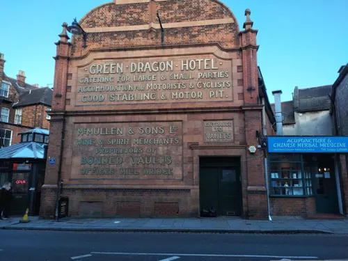
- Former Green Dragon Hotel stables, Hertford 01, Paul the Archivist, CC BY-SA 4.0
- Former Green Dragon Hotel stables, Hertford 02, Paul the Archivist, CC BY-SA 4.0
- CAFE ROUGE HERTFORD UK - panoramio, Oscar Arky, CC BY 3.0
- GOC Bayford–Hertford 038 Fomer stables to the former Green Dragon Hotel, Hertford (26318119321), Peter O'Connor aka anemoneprojectors, CC BY-SA 2.0
- KingsmeadViaductFromWare, Jamsta at English Wikipedia, CC BY-SA 3.0
- Hertford Museum, Caitlin from Hertfordshire, UK, CC BY 2.0
- Willowmead 2, Dudley Miles, CC BY-SA 4.0
- Amwell Quarry 16, Dudley Miles, CC BY-SA 4.0
- Hertford Heath north 9, Dudley Miles, CC BY-SA 4.0
- All Saints' Church, Hertford 1 2020-09-01, Colin, CC BY-SA 4.0
- St Leonard's Church, Bengeo 1 2020-08-23, Colin, CC BY-SA 4.0
- Hertford Castle, Caitlin from Hertfordshire, UK, CC BY 2.0
- Simon Balle School entrance, GMK239, CC BY-SA 3.0
- St. Marys Church Hertingfordbury, The original uploader was Roundtheworld at English Wikipedia ., CC BY-SA 3.0
- Quaker Meeting House - Hertford England, Equus caballus, CC BY-SA 3.0
- Salisbury Arm Hotel, Hertford 2022-12, IrishCornelius, CC BY-SA 4.0
- Hertingfordbury railway station (1953), Lamberhurst, CC BY-SA 4.0
- The White Hart Inn, Salisbury Square, Hertford, November 2022, No Swan So Fine, CC BY-SA 4.0
- Church of St Andrew, Hertford, November 2022 03, No Swan So Fine, CC BY-SA 4.0
- White Horse, Hertford, Paul the Archivist, CC BY-SA 4.0
- Six Templars Hertford, RobThinks, CC BY-SA 4.0
- HarthamPlaygroundSnow, The original uploader was Jamsta at English Wikipedia ., CC BY-SA 2.5
- Balls Wood 8, Dudley Miles, CC BY-SA 4.0
- Danemead 5, Dudley Miles, CC BY-SA 4.0
- King's Meads, Ware (51134249639), Peter O'Connor aka anemoneprojectors, CC BY-SA 2.0
- GOC Hoddesdon 006 Barclay Park, Hoddesdon (29176082382), Peter O'Connor aka anemoneprojectors, CC BY-SA 2.0
- Street-level photo, tonys999, CC BY-SA 4.0
- Street-level photo, tonys999, CC BY-SA 4.0
- Street-level photo, tonys999, CC BY-SA 4.0
- Street-level photo, tonys999, CC BY-SA 4.0
- Street-level photo, tonys999, CC BY-SA 4.0
- Street-level photo, tonys999, CC BY-SA 4.0
- Street-level photo, tonys999, CC BY-SA 4.0
- Street-level photo, wasd42, CC BY-SA 4.0
- Street-level photo, tonys999, CC BY-SA 4.0
- Street-level photo, tonys999, CC BY-SA 4.0
- Street-level photo, tonys999, CC BY-SA 4.0
- Street-level photo, tonys999, CC BY-SA 4.0
- Street-level photo, tonys999, CC BY-SA 4.0
- Street-level photo, tonys999, CC BY-SA 4.0
- Street-level photo, tonys999, CC BY-SA 4.0
- Street-level photo, tonys999, CC BY-SA 4.0


Page built November 10, 2026. Spotted a mistake? Tell us or suggest a place.