



Milverton, United Kingdom
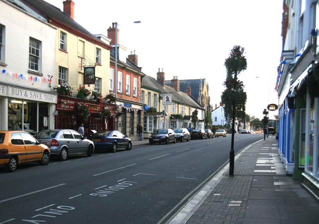
Milverton is a town of 1,112 people in England, United Kingdom.
Why visit Milverton
Townapedia lists 2 museums and landmarks, 1 park or trail and 1 attraction in and around town.
Highlights include Tone Aqueduct, Longforth Farm and Wellington Museum.
Weather in Milverton
Forecast from MET Norway (CC BY 4.0). Full forecast
About Milverton
Milverton is a village and civil parish in Somerset, England, situated in the valley of the River Tone 5 miles (8.0 km) west of Taunton. The village has a population of 1,438. The parish includes the hamlet of Preston Bowyer.
From the Wikipedia article Milverton, Somerset (this version), under CC BY-SA 4.0.
Things to do1

Museums and landmarks2

Longforth Farm
Monument and historic site · 2.7 mi
Archaeological site in Wellington, Somerset West and Taunton, England, UK

Wellington Museum
Museum · 3.3 mi
Hotel in Wellington, Taunton Deane, Somerset, England, UK
Parks, trails and playgrounds1

Churches and places of worship16

Church of All Saints, Nynehead
Church · 2.0 mi
Church in Nynehead, UK

Church of St Andrew
Church · 2.8 mi
Church in Wiveliscombe, Somerset, England, UK

Church of St Bartholomew
Church · 1.9 mi
Church in Oake, Somerset, England, UK

Church of St James the Great
Church · 1.7 mi
Church in Fitzhead, Somerset, England, UK

Church of St John the Baptist, Wellington
Church · 3.1 mi
Church in Wellington, Somerset, England, UK

Church of St Bartholomew
Church · 2.9 mi
Church building in Bathealton, Taunton Deane, Somerset, England, UK
Church of St James the Less
Church · 1.7 mi
Church in Halse, Somerset, England, UK
Church of St John the Baptist
Church · 2.4 mi
Church in Heathfield, Somerset, England, UK
Church of St Margaret
Church · 3.2 mi
Church in Thorne St Margaret, Somerset, England, UK
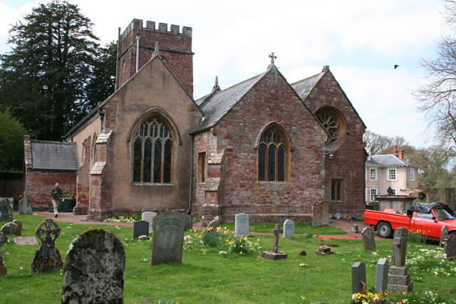
Church of St Michael, Milverton
Church
Church in Milverton, Somerset, England, UK
Church of St Peter and St Paul, Runnington
Church · 2.3 mi
Church in Langford Budville, Somerset, England, UK
Church of St. Peter, Langford Budville
Church · 1.8 mi
Church in Langford Budville, UK
4 more on the map.
History
The name of the village is believed to come from the Old English and mean settlement at the mill ford. There is evidence of a mill within the parish from the Domesday Book of 1086. These referred to the site of the Town Mills on Hillfarrence Brook.
Neolithic flint arrowheads have been found to the west of the village and Bronze Age axe heads were discovered when the bypass, which opened in 1975, was being built.
Just before the Norman Conquest, Milverton was granted by Queen Edith of Wessex to Gisa, Bishop of Wells, but this was reversed by William the Conqueror. The manor was then united with Torrington in Devon, passing in 1212 to William Briwere. The parish was part of the Milverton Hundred.
The Old House is a Grade II* listed building dating from the late 14th and early 15th century. It was built as a residence for the archdeacon of Taunton and was once the home of Thomas Cranmer. While the house was being renovated in the early 21st century a Tudor wall painting of Henry VIII was discovered underneath the plaster and is the only one of its kind in a domestic dwelling. It has been speculated that there is a secret message in the image., which has been dated to around 1541.
In 1708 there was a fire which destroyed 13 properties. Trade was largely based on cloth manufacture and in 1819 Lamech Swift established a silk throwing factory which employed up to 300 women and children.
Read more of the history
The village used to have a station on the Devon and Somerset Railway, which closed in 1966.
Milverton is the location of noted plant nursery Junkers Nursery, which specialises in unusual shrubs and trees including Acer palmatum, Betula, Cornus, Daphne, Magnolia, Parrotia, Stewartia and Styrax,
The village of Milverton has a notable Quaker history, beginning in 1679 when Edward Pole made land available on the parish boundary with Wiveliscombe for use as a burial ground and meeting house. This occurred during a period of restrictions on nonconformist worship under laws such as the Conventicle Act 1664, which led many Quakers—including those from Milverton—to face fines, imprisonment, or the seizure of property for refusing to pay church tithes or swear oaths of allegiance. Friends also participated in meetings held at Ilchester Gaol, where Quaker prisoners were sometimes allowed to congregate together.
A formal Quaker meeting house was registered at Milverton in 1684, following the Act of Toleration. In 1753, a purpose-built meeting house was constructed beside the Pole family home, known as "The Recess," which served as a focal point for both worship and education through a small Quaker school.
The former Quaker burial ground, now located off Quaking House Lane west of the village, contains memorials spanning over two centuries. It has been maintained periodically by the Quaker community and is listed in the Quaker Cemeteries Register. Milverton was administratively part of the West Somerset Monthly Meeting, linked to other nearby meetings in Taunton, Wellington, and Bridgwater. Among those serving as trustees was Elias Osborne of Chard, a prominent Quaker who oversaw multiple Friends' properties during the late 17th century.
Elements of the original meeting house still exist in the fabric of Ivy Cottage (also known as the Old Quaker House) on North Street, which is now a Grade II listed building. The renowned scientist Thomas Young was born in Milverton in 1773 and grew up in a Quaker household connected to the local meeting.
From the History section of Milverton, Somerset on Wikipedia, under CC BY-SA 4.0.
Notable people from Milverton
 Thomas YoungEnglish polymath (1773-1829)Photo: Henry Perronet Briggs, CC BY-SA 4.0
- Percy EbdonEnglish cricketer (1874-1943)
Born in Milverton, according to Wikidata (CC0). Each name links to its Wikipedia article.
Shopping1
Schools, colleges and libraries1
Map of Milverton
22 places. The map loads OpenStreetMap tiles when you open it.
Getting there and nearby towns
Exeter Airport (EXT) is the nearest airport with scheduled flights listed in OpenStreetMap, 21 miles away.
- Taunton 7 mi east, about 10 min by car
- Sampford Peverell 9 mi southwest, about 15 min by car
- Nether Stowey 10 mi northeast, about 16 min by car
- Bridgwater 13 mi northeast, about 21 min by car
- Tiverton 13 mi southwest, about 22 min by car
- Dulverton 13 mi west, about 21 min by car
- Westonzoyland 15 mi northeast, about 25 min by car
- Honiton 16 mi south, about 25 min by car
- Minehead 16 mi northwest, about 26 min by car
- Chard 16 mi southeast, about 26 min by car
Drive times are estimates from straight-line distance, not routes.
Towns near Milverton


Keep exploring
Local news
Headlines from INDB.
Reviews, tips and questions
Loading what members have shared...
Sources and licences
- GeoNames (CC BY 4.0): population, coordinates, regions and time zone
- OpenStreetMap contributors (ODbL 1.0): places, airports, map data
- Wikidata (CC0 1.0): elevation, founding date, time zone, website, landmarks and historic places
- Wikimedia Commons (see each image): photos
- Wikipedia (CC BY-SA 4.0): overview and history text
Photo credits
- Longforth 12 july 2013 7, SANHS, CC BY-SA 3.0
- Wellington Fore Street, roger geach, CC BY-SA 2.0
- Nyneheadchurch, Martin Bodman, CC BY-SA 2.0
- Wiveliscombe church, Ross Burgess, CC BY 3.0
- St Bartholomew's Church, Oake 04, Simon Burchell, CC BY-SA 4.0
- Fitzgead church, Martin Bodman, CC BY-SA 2.0
- St John the Baptist, Wellington, Derek Harper, CC BY-SA 2.0
Page built November 10, 2026. Spotted a mistake? Tell us or suggest a place.