


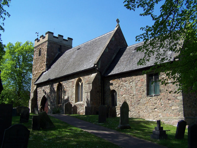
Mountsorrel, United Kingdom
Mountsorrel is a town of 17,297 people in England, United Kingdom.
Why visit Mountsorrel
Townapedia lists 5 museums and landmarks, 13 parks and trails, 34 places to eat, 3 places to stay and 2 attractions in and around town.
Highlights include Mountsorrel Cross, Stonehurst Family Farm and Motor Museum, Birstall Meadows and Halstead Road Centenary Pasture.
Weather in Mountsorrel
Forecast from MET Norway (CC BY 4.0). Full forecast
About Mountsorrel
Mountsorrel is a large village in Leicestershire on the River Soar, just south of Loughborough. In 2021, it had a population of 12,885. It previously had a population in 2001 of 6,662 inhabitants, increasing to 8,223 at the 2011 census.
From the Wikipedia article Mountsorrel (this version), under CC BY-SA 4.0.
Photos of Mountsorrel


Things to do2

Museums and landmarks5


Stonehurst Family Farm and Motor Museum
Museum · 1.1 mi
Public museum and farm in Mountsorrel, Leicestershire

Parks, trails and playgrounds13



Cossington Meadows
Park · 1.4 mi
Nature reserve in Leicestershire, England


1 more on the map.
Restaurants and cafes34

The Fire Station Pizzeria
Restaurant · Pizza · 0.7 mi
18 Cross Green
We-Sa 17:00-23:00; Su 16:00-21:00

22 more on the map.
History
A castle was built in 1080 by Hugh Lupus, but there is evidence of an earlier Norman settlement in the area in the form of pottery fragments. A Roman villa is supposed to have existed on Broad Hill during the 4th century AD, the site of today's quarry, as quarrying during the late 1800s revealed many artefacts including a preserved wooden bucket. However, the first recording of the village was in 1377, when it had a population of 156.
In 1151, Robert le Bossu, the Earl of Leicester and deputy to Henry II of England, who was the Justicar, or Chief Justice of the Peace for the area, acquired the tenancy of Mountsorrel castle. According to the historian Jim Bradbury, the acquisition of the castle by the Earl of Leicester was as a result of a 'final concord of peace' with Ranulf, Earl of Chester.
Whilst the origin of the name 'Mountsorrel' is still not understood fully, it is thought that the English nobility of the time named Mountsorrel after Montsoreau castle, a castle in France close to Fontevrault, where Henry II was buried. The name Mountsorrel is of Norman-French origin and is thought to have developed due to the close likeness of Montsoreau and Mountsorrel – both settlements sit on rivers, the Loire and the Soar respectively, and are overshadowed by surrounding hills.
Read more of the history
Mountsorrel castle was used as a bastion against King Stephen, and was subsequently destroyed in 1217 by the King's men from Nottingham, branded "a nest of the Devil and den of thieves and robbers". The future King Louis VIII of France had sent support in the form of 20,000 men to the besieged barons in the castle, but this force had failed to arrive in time to prevent the razing to the ground of the castle. All that remains of the castle today is a granite crag on Castle Hill. The hill is also the site of a memorial (by Shirley Harrison, 1926) to those who lost their lives in World War I.
One of the parish churches is Christ Church and the other, a Grade II* listed building, is dedicated to St Peter.
The village was visited by Methodist preacher John Wesley, where he preached in a building which now belongs to Stonehurst Family Farm, a tourist attraction. By an act of Parliament passed on 22 July 1782 Henry Walkery of Thurmaston and John Sultzer of Burton Overy were empowered to enclose the open fields and common grounds of Mountsorrel, some 300 acres (120 hectares). The Leicester Navigation was opened in 1794 and the first barges between Loughborough and Leicester departed on 26 October.
Mountsorrel was the site for a hospital for the mentally ill, which had 91 beds in 1979, but this has since closed and been converted to a housing estate.
By 1781, the population was recorded as '150 dwellings', and by 1840 the population of Mountsorrel had reached 1,900. During World War II, in 1942, Alvis, an armoured vehicle manufacturer based in Coventry, acquired a factory previously used to produce cardboard boxes in the village after their factory in Coventry was bombed by the Luftwaffe. Alvis built a new factory on the site of an old brickworks, which DeHavilland, an aeroplane propeller manufacturer, briefly used after the war until Rolls-Royce Limited acquired the site in 1945. The site has since closed and is now covered by housing (see below).
The A6 dual-carriageway Quorn-Mountsorrel Bypass opened in October 1991, allowing quarry traffic to avoid travelling through the village centre. On 31 July 2004 a new leisure centre opened in the village, the Soar Valley Leisure Centre. Christ Church & St Peters primary school is on Rothley Road.
The Stonehurst Family Farm and Motor Museum established in 1951 is located in the centre of the village and is home to many animals and offers tractor trailer rides.
The Butter Market was built in 1793 by the Lord of the manor, Sir John Danvers, to replace the fifteenth century Mountsorrel Cross, a market cross which he removed for use as an ornamental garden feature on his estate in Swithland, where it still remains. It is a Grade II* listed structure.
The Adam Style building opposite St Peter's Church and actually on the Leicester to Loughborough road, was built in 1783 for Ralph Tebbutt, whose monument is in St Peter's Church. Formerly known as Mountsorrel Hall it was a vicarage until 1983.
A copy of this building was erected in 1790 in Liverpool, and in that house the politician and former Prime Minister, William Ewart Gladstone (1809–1898) was born.
From the History section of Mountsorrel on Wikipedia, under CC BY-SA 4.0.
More about Mountsorrel
Geography
The village is in the borough of Charnwood, surrounding a steep hill, once crowned by a castle, and is bordered to the east by the River Soar.
The village is renowned for the Buttercross Market in the village centre as well as its granite quarry, the largest in Europe. The Leicester arm of the Grand Union Canal runs through Mountsorrel.
The civil parish meets with Rothley to the south, and some houses are actually in Rothley parish near the southern A6 junction. To the west of the parish is a nature reserve. North of here, the Leicestershire Round passes east–west through the north of the village. The parish boundary meets Quorndon where it first meets the quarry near Buddon Wood. North of there, it crosses the former A6, 500 metres (1,600 ft) towards Quorn from the roundabout for the A6 roundabout. Close to the bypass, the River Soar becomes the parish boundary and south of the A6 northern junction it meets Sileby at the point where it crosses the A6 bypass. Five hundred metres (one thousand six hundred feet) south of there, the boundary leaves the river to the west, with the river becoming the Sileby-Rothley boundary.
The local area is built on granite. Leicester's Humberstone came from this granite (igneous rock), and was originally known as Hunbeort's Stan. Another piece of Mountsorrel granite is at an RAF memorial at Screveton in Nottinghamshire near the A46.
From the Wikipedia article Mountsorrel, under CC BY-SA 4.0.
Notable people from Mountsorrel
- Ernest GillEnglish footballer and cricketer (1877-1950)
- George GillEnglish cricketer (1876-1937)
- Percy TurnerEnglish footballer (1879-1954)
- Rebecca Wakefield[née Brewin], (1844–1873), missionary wife
Born in Mountsorrel, according to Wikidata (CC0). Each name links to its Wikipedia article.
Where to stay3
Churches and places of worship18
Church of St Mary the Virgin and St John the Baptist, Rothley
Church · 0.9 mi
Shopping5
Schools, colleges and libraries5
Swithland St Leonard's Church of England Primary School
School · Anglican · 1.5 mi
Main Street, Loughborough
Christ Church & Saint Peter's Cofe Primary School
School · Anglican · 0.7 mi
8 Rothley Road, Loughborough
Healthcare2
Map of Mountsorrel
87 places. The map loads OpenStreetMap tiles when you open it.
Getting there and nearby towns
East Midlands Airport (EMA) is the nearest airport with scheduled flights listed in OpenStreetMap, 11 miles away.
- Syston 4 mi southeast, about 7 min by car
- Leicester 5 mi south, about 9 min by car
- Shepshed 7 mi northwest, about 11 min by car
- Oadby 8 mi south, about 13 min by car
- Stapleford 15 mi north, about 24 min by car
- Nottingham 16 mi north, about 26 min by car
- Oakham 18 mi east, about 29 min by car
- Derby 20 mi northwest, about 32 min by car
- Burton upon Trent 22 mi west, about 35 min by car
- Coventry 26 mi southwest, about 42 min by car
Drive times are estimates from straight-line distance, not routes.
Towns near Mountsorrel


Keep exploring
Local news
Headlines from INDB.
Reviews, tips and questions
Loading what members have shared...
Sources and licences
- GeoNames (CC BY 4.0): population, coordinates, regions and time zone
- Mapillary (see each image): photos
- OpenStreetMap contributors (ODbL 1.0): places, airports, map data
- Wikidata (CC0 1.0): elevation, founding date, time zone, website, landmarks and historic places
- Wikimedia Commons (see each image): photos
- Wikipedia (CC BY-SA 4.0): overview and history text
Photo credits
- Mountsorrel War Memorial, Michig, CC BY-SA 3.0
- Birstall Meadows 5, Dudley Miles, CC BY-SA 4.0
- Moira Junction 8, Dudley Miles, CC BY-SA 4.0
- Mountsorrel Meadows 2, Dudley Miles, CC BY-SA 4.0
- River Soar from Wanlip Meadows 2, Dudley Miles, CC BY-SA 4.0
- Birstall Church, Kev747 at English Wikipedia, Public domain
- Quorn Baptist Church, Meeting Street, Quorn (NHLE Code 1278812) (June 2025) (10), User:Hassocks5489, CC0
- Primitive Methodist Church, Sileby, Andrewrabbott, CC BY-SA 4.0
- Wesleyan Methodist Church, Sileby, Andrewrabbott, CC BY-SA 4.0
- Quorn Parish Church, Thomas Willson Tombon at English Wikipedia, CC BY-SA 3.0
- Mountsorrel cross, Duncan Harris, CC BY-SA 2.0
- Watermead Country Park, Unknown author, CC BY-SA 3.0
- Halstead Road Centenary Pasture 4, Dudley Miles, CC BY-SA 4.0
- Halstead Road Centenary Pasture 5, Dudley Miles, CC BY-SA 4.0
- Halstead Road Centenary Pasture 3, Dudley Miles, CC BY-SA 4.0
- Halstead Road Centenary Pasture 2, Dudley Miles, CC BY-SA 4.0
- Broadnook Park (1) - 29 May 2026, Aethonatic, CC0
- Pom Pom Park - 29 May 2026, Aethonatic, CC0
- Street-level photo, adam2, CC BY-SA 4.0
- Street-level photo, trigpoint, CC BY-SA 4.0
- Street-level photo, trigpoint, CC BY-SA 4.0
- Street-level photo, trigpoint, CC BY-SA 4.0
- Street-level photo, trigpoint, CC BY-SA 4.0
- Street-level photo, trigpoint, CC BY-SA 4.0
- Street-level photo, trigpoint, CC BY-SA 4.0
- Street-level photo, trigpoint, CC BY-SA 4.0


Page built November 10, 2026. Spotted a mistake? Tell us or suggest a place.