
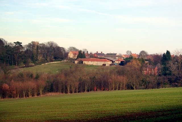

Why visit Navenby
Townapedia lists 13 museums and landmarks, 2 parks and trails and 9 places to eat in and around town.
Highlights include Lincoln Road and High Dyke.
Weather in Navenby
Forecast from MET Norway (CC BY 4.0). Full forecast
About Navenby
Navenby is a village and civil parish in the North Kesteven district of Lincolnshire, England. Lying 8 miles (13 km) south from Lincoln and 9 miles (14 km) north-northwest from Sleaford, Navenby had a population of 2,361 in the 2021 census. In March 2011, it was named as the 'Best Value Village' in England following a national survey.
From the Wikipedia article Navenby (this version), under CC BY-SA 4.0.
Museums and landmarks13


1 more on the map.
Parks, trails and playgrounds2


Restaurants and cafes9

Akash Indian Restaurant & Takeaway
Restaurant · Indian
16 High Street, Lincoln
Mo-Su 17:00-23:00




Churches and places of worship4


History
Archaeological investigations around Navenby indicate the area has been occupied since at least the British Bronze Age, about 600 BC. The remains of British Iron Age farms have been found at Chapel Lane, a site now protected as a public open space by the district and parish councils and supported by
Significant Roman finds include parts of shops and houses that would have fronted onto Ermine Street, down which Roman armies marched to and from the Legionary Fortress at Lincoln. The city of Lincoln was very important at that time, probably the capital of the late Roman Province of Flavia Caesariensis. Evidence suggests that Navenby was a significant staging point along Ermine Street. The Romans are reported to have maintained a small base or garrison in the village, and a possible Romano-British temple and burial sites have been unearthed in the area. A 2009 archaeological dig uncovering a road, building foundations and Roman graves along with pottery and coins, showed Navenby to be a Roman Service Station.
Cremations dated to the middle Saxon period have been discovered near the junction of High Dyke with Chapel Lane. Late Saxon remains have also been found under and around St Peter's Church, suggesting the original Roman village had moved from Ermine Street to Church Lane and North Lane by the late-Saxon period.
Read more of the history
Navenby's Saxon name is unknown. The present name is derived from the Old Norse Nafni+by, which means "farmstead or village of a man called Nafni". In the Domesday Book of 1086, Navenby appears as Navenbi and Navenebi. The Vikings exerted considerable influence over Lincolnshire in the 9th and 10th centuries, as can be seen in the many local place names ending in -by. The Viking Way, a 147-mile (237 km) footpath that cuts through the village, is a lasting reminder of their presence.
Navenby, originally an agricultural village, became a market town after receiving a charter from Edward the Confessor in the 11th century. The charter was later renewed by William Rufus, Edward III, and Richard II.
The wide main street, down which farmers once drove their sheep to market, is lasting evidence of its market town status. A market square once stood at the centre, marked by a cross in honour of Queen Eleanor. Today, the square has gone and the cross is a ruin.
Parish records exist for Navenby from 1681, although bishops' transcripts go back to 1562. The documents show the village hosted several annual fairs each year: a market fair on 17 October at which farm animals were traded; a feast on the Thursday before Easter; and a Hiring Fair held each May Day, at which servants gathered to seek employment.
The records also show that part of the parish of Navenby was enclosed in 1772. Such was the significance of Navenby at this time that a workhouse for the parish poor was erected here, although the building was later given over to other uses. A Sick Society was founded in 1811 and a Parish School was built next to St Peter's Church in 1816, paid for by subscription. Following the Poor Law Amendment Act 1834 Navenby parish became part of the Lincoln Poor Law Union.
When the market closed in the early 19th century Navenby lost its status as a market town, and once again became an agricultural village. The Penny Cyclopaedia of 1839, published by The Society for the Diffusion of Useful Knowledge, described the village in this way:
Navenby is in the hundred of Boothby Graffoe, parts of Kesteven, on the road from Grantham to Lincoln, 124 miles [200 km] from London.
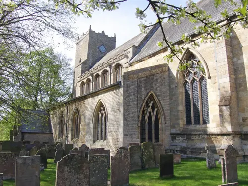
The church is partly of Early English and partly of Decorated English architecture. The windows of the chancel are very fine specimens of Decorated character, particularly the east window, the mullions and tracery of which are remarkably graceful.
There were in 1833 two dame schools, with 18 children; two day-schools, with 25 children; and one endowed day and Sunday school, with 109 children in the week and 166 on Sunday.
Many buildings were erected in Navenby during the 19th century, including a small Wesleyan Methodist chapel in about 1830, which was completely rebuilt in 1840. A Temperance Hall was built in 1852, later used as a second base by the Wesleyan Reformers.
A Volunteer Fire Brigade was founded in 1844, comprising five men and a manual engine. The Provincial Gas Light and Coke Company began supplying gas lighting to the village in 1857, and in 1867 a railway station was built three-quarters of a mile (1.2 km) west of the village, on the Lincoln-to-Grantham branch of the Great Northern Railway.
By 1871, the Dean and Chapter of Lincoln was the principal landowner and Lord of the manor of Navenby. A witch bottle was discovered in the foundations of a Navenby farmhouse in 2005, thought to date back to about 1830. Containing pins, human hair and urine, the bottle was believed to protect a household against evil spells.
Navenby was an agricultural village at the beginning of the 20th century, but the outbreak of the First World War brought changes for the community. A small airfield, Wellingore Heath, was opened on land bordering Navenby in 1917, to provide a base for the Royal Flying Corps and the Royal Naval Air Service. The flat landscape, with its cliff-top situation, proved an ideal situation for flight operations.
T. E. Lawrence, perhaps better known as Lawrence of Arabia, was stationed at nearby RAF Cranwell just after the war, in 1926, where he wrote a revised version of his Seven Pillars Of Wisdom. He mentioned Navenby in a letter to a friend at the time, saying: I'm too shy to go looking for dirt. That's why I can't go off stewing into the Lincoln or Navenby brothels with the fellows. They think it's because I'm superior: proud, or peculiar or 'posh', as they say: and it's because I wouldn't know what to do, how to carry myself, where to stop. Fear again: fear everywhere.
From the History section of Navenby on Wikipedia, under CC BY-SA 4.0.
More about Navenby
Geography
The civil parish of Navenby straddles the old Roman Ermine Street, known locally as High Dyke. The road runs between the neighbouring villages of Boothby Graffoe and Wellingore and covers more than 2,100 acres (850 ha). The Viking Way, a 147-mile (237 km) footpath between the Humber Bridge in North Lincolnshire and Oakham in Rutland, also passes through the village.
Navenby is known as a Lincolnshire Cliff Village, as it is situated on a ridge of Jurassic limestone called the Lincoln Edge or Lincoln Cliff. The small cliff is one of the most distinctive hills in Lincolnshire. Lying 8.7 miles (14 km) south of Lincoln and 8.9 miles (14.3 km) north-northwest of Sleaford, Navenby enjoys warm summers and dry frosty winters.
During the Ice Age, most of the region surrounding Navenby was covered by ice sheets and this has influenced the topography and nature of the soils. Much of Lincolnshire is low-lying, in some places below sea level, but Navenby's cliff-top position means it is 226 feet (69 m) above sea level, giving it commanding views over the River Witham valley.
The parish of Navenby is elongated in an east–west direction, extending east to the Lincoln Heath and west to the River Brant. The size of the parish has varied over the past two centuries. In 1821 it covered 2,110 acres (854 ha); in 1951 it was 3,345 acres (1,354 ha).
Economy
Navenby was originally an agricultural village, with most people living off the land or trading goods in the local market. Statistics show that, in 1841, 48% of villagers worked in agriculture, but today the majority of villagers, 67%, are employed in the service industry and most commute to work away from Navenby. The village does, however, offer limited work opportunities, with the High Street lined with shops, fast-food stores and public houses. A doctors' surgery, building society and residential care home are based in the village, although the post office closed in January 2011.
The local newspaper for Navenby is the Lincolnshire Echo, which includes news and sports reports, as well as job advertisements. The local radio stations for the village are BBC Radio Lincolnshire on 94.9 FM and Greatest Hits Radio on 102.2 FM. The newest addition to the local airwaves is Siren FM, a community radio station that broadcasts on 107.3 FM from the University of Lincoln.
Arts and culture
Navenby used to be served by several public houses, but The Butcher's Arms and The Green Man Inn have long been converted into private houses. Now, just the King's Head and The Lion and Royal remain.
The Grade II listed 18th-century King's Head is probably the oldest public house in the village; the nearby Lion and Royal dates from 1824 and is also Grade II listed. It was probably just called "The Lion" when it first opened, but added "Royal" to its name in honour of a special visitor. There is a large emblem over the front door, topped by the Prince of Wales's feathers, presented after the Prince (later Edward VII) stayed there, albeit briefly, in 1870.
The former Green Man Inn, at the junction of Green Man Lane and the A15, was once a staging post for travellers and may have also been a court house. The Lincoln Club was established here in about 1741, catering for the "distinguished gentlemen of Lincolnshire". Sir Francis Dashwood, founder of the notorious Hellfire Club, was a member, as were Lord Monson of Burton and Lord Robert Manners of Bloxholm.
Education
Navenby is served by its own village school, Navenby Church of England Primary School. It is a voluntary controlled school for children aged 4–11. There is a choice of nearby senior schools for older Navenby pupils, although none are within the village. Lincolnshire County Council operates a preference system for parents, which allows them to choose a preferred school, rather than one for which they are in the catchment area. The closest senior school to Navenby, and the one that is within the Designated Transport Area, is Sir William Robertson High School at Welbourn. This is a mixed comprehensive school named after Field Marshal William Robertson, who was born in Welbourn and served in the First World War.
Other senior schools within a 10-mile (16 km) radius include Branston Community Academy, and two grammar schools in nearby Sleaford – Carre's Grammar School for boys and Kesteven and Sleaford High School for girls. Private schools are available in Lincoln. Many local senior schools offer sixth form tuition, and further education courses for students aged 16 and over are also provided by Lincoln College, which is the largest educational institution in Lincolnshire. It has 18,500 students, of whom 2,300 are full-time.
Nearby Lincoln has two higher education institutions, the older Bishop Grosseteste University and the more recent, larger University of Lincoln.
From the Wikipedia article Navenby, under CC BY-SA 4.0.
Notable people from Navenby
 Hamlet ClarkBritish naturalist and entomologist (1823-1867)Photo: Southwell studio, Public domain
Born in Navenby, according to Wikidata (CC0). Each name links to its Wikipedia article.
Shopping2
Gas and EV charging1
Schools, colleges and libraries1
Map of Navenby
32 places. The map loads OpenStreetMap tiles when you open it.
Getting there and nearby towns
RAF Waddington (WTN) is the nearest airport with scheduled flights listed in OpenStreetMap, 4 miles away.
- Cranwell 6 mi southeast, about 9 min by car
- Leasingham 7 mi southeast, about 11 min by car
- Lincoln 8 mi north, about 13 min by car
- Sleaford 9 mi southeast, about 14 min by car
- Ancaster 9 mi south, about 14 min by car
- Skellingthorpe 10 mi northwest, about 16 min by car
- Reepham 10 mi northeast, about 15 min by car
- North Collingham 10 mi west, about 16 min by car
- Nettleham 11 mi north, about 18 min by car
- Newark on Trent 12 mi west, about 20 min by car
Drive times are estimates from straight-line distance, not routes.
Towns near Navenby


Keep exploring
Local news
Headlines from INDB.
Reviews, tips and questions
Loading what members have shared...
Sources and licences
- GeoNames (CC BY 4.0): population, coordinates, regions and time zone
- Mapillary (see each image): photos
- OpenStreetMap contributors (ODbL 1.0): places, airports, map data
- Wikidata (CC0 1.0): elevation, founding date, time zone, website
- Wikimedia Commons (see each image): photos
- Wikipedia (CC BY-SA 4.0): overview and history text
Photo credits
- Navenby, Richard Croft, CC BY-SA 2.0
- St Andrew's , Boothby Graffoe, Lincolnshire, Brian, CC BY-SA 2.0
- Street-level photo, coljay72, CC BY-SA 4.0
Page built November 10, 2026. Spotted a mistake? Tell us or suggest a place.