


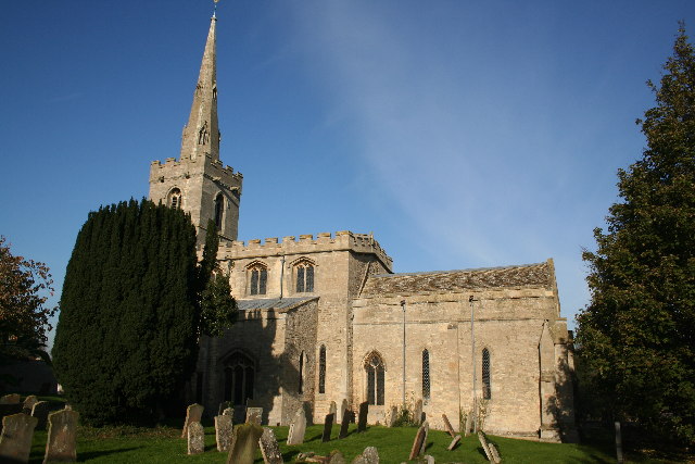
Why visit Ancaster
Townapedia lists 11 museums and landmarks, 5 places to eat, 2 places to stay and 1 attraction in and around town.
Highlights include Roman marching camp and Roman settlement.
Weather in Ancaster
Forecast from MET Norway (CC BY 4.0). Full forecast
About Ancaster
Ancaster is a village and civil parish in the South Kesteven district of Lincolnshire, England, on the site of a Roman town. The population of the civil parish was 1,317 at the 2001 census, increasing to 1,647 at the 2011 census. The civil parish includes the settlements of Sudbrook and West Willoughby.
From the Wikipedia article Ancaster, Lincolnshire (this version), under CC BY-SA 4.0.
Things to do1
Museums and landmarks11

Restaurants and cafes5

Woody's Bar & Lakeview Restaurant
Restaurant · 0.6 mi
Willoughby Road, Grantham
Mo-Th 12:00-20:30; Fr,Sa 12:00-21:00; Su 12:00-18:00

Where to stay2

History
Ancaster was a Roman town at the junction of the Roman roads of Ermine Street and King Street.
During the Romano-British period, the Romans built a roadside settlement on the site of a "Corieltauvi" settlement. It was traditionally thought to have been named "Causennis," although that is now believed to be Saltersford near Grantham. Ancaster lies on Ermine Street, the major Roman road heading north from London. To the north-west of Ancaster is a Roman marching camp, and some 4th-century Roman earthworks are still visible. Excavations have found a cemetery containing more than 250 Roman burials, including 11 stone sarcophagi. In the later years of Roman occupation, a large stone wall with accompanying ditches was erected around the town, possibly for defence against marauding Saxons.
The place name Ancaster is first attested in a 12th-century Danelaw charter from the reign of Henry II, and in a legal document of 1196, where it appears as Anecastre. The name means "the Roman fort of 'Anna'."
An excavation by the television programme Time Team in 2001 revealed a cist burial bearing an inscription to the god Viridius. The dig also uncovered Iron Age to 3rd-century pottery, a 1st-century brooch, and some of the Roman town wall.
Ancaster Hall at the University of Nottingham was named after the parish, as was the extinct title of the Earl of Ancaster.
Read more of the history
In 2005, the once widespread but now rare tall thrift plant was discovered in Ancaster churchyard, one of only two places in the country where the plant has been found to occur. A preservation regime for the plant was instituted by English Nature.
The town of Ancaster in Ontario, Canada, was established in Upper Canada in 1792 and was named after Ancaster, Lincolnshire, by British army officer and the first Lieutenant Governor of Upper Canada John Simcoe, apparently inspired to do so by Peregrine Bertie, the 3rd Duke of Ancaster and Kesteven.
From the History section of Ancaster, Lincolnshire on Wikipedia, under CC BY-SA 4.0.
More about Ancaster
Geography
The River Trent formerly flowed east from the Nottingham area towards the North Sea, via the Vale of Belvoir and the Ancaster Gap in the limestone ridge to the north known as the Lincoln Cliff.
Ancaster lies midway between Sleaford and Grantham on the A153 road, at its junction with the B6403 (Ermine Street). North of the village, the B6403 (High Dike) is the dividing line between South and North Kesteven. Towards Sleaford lies Wilsford and to the west Sudbrook.
The civil parish boundaries are different: the civil parish also covers the settlements of Sudbrook and West Willoughby.
From the Wikipedia article Ancaster, Lincolnshire, under CC BY-SA 4.0.
Notable people from Ancaster
- Lionel Browncricketer (1872-1938)
- Thomas DuffieldMember of House of Commons of the United Kingdom (1782-1854)
Born in Ancaster, according to Wikidata (CC0). Each name links to its Wikipedia article.
Churches and places of worship4
Shopping2
Schools, colleges and libraries1
Map of Ancaster
26 places. The map loads OpenStreetMap tiles when you open it.
Getting there and nearby towns
RAF Waddington (WTN) is the nearest airport with scheduled flights listed in OpenStreetMap, 12 miles away.
- Sleaford 5 mi east, about 9 min by car
- Cranwell 5 mi northeast, about 8 min by car
- Leasingham 5 mi northeast, about 9 min by car
- Grantham 7 mi southwest, about 11 min by car
- Billingborough 10 mi southeast, about 16 min by car
- Corby Glen 12 mi south, about 19 min by car
- Newark on Trent 13 mi northwest, about 21 min by car
- Colsterworth 13 mi south, about 20 min by car
- Bourne 16 mi southeast, about 26 min by car
- Lincoln 17 mi north, about 27 min by car
Drive times are estimates from straight-line distance, not routes.
Towns near Ancaster


Keep exploring
Local news
Headlines from INDB.
Reviews, tips and questions
Loading what members have shared...
Sources and licences
- GeoNames (CC BY 4.0): population, coordinates, regions and time zone
- Mapillary (see each image): photos
- OpenStreetMap contributors (ODbL 1.0): places, airports, map data
- Wikidata (CC0 1.0): elevation, founding date, time zone, website, landmarks and historic places
- Wikimedia Commons (see each image): photos
- Wikipedia (CC BY-SA 4.0): overview and history text
Photo credits
- Ancaster cross and Launde House, Alan Murray-Rust, CC BY-SA 2.0
- Ancaster Hall, Alan Murray-Rust, CC BY-SA 2.0
- St Mary's, Wilsford, Richard Croft, CC BY-SA 2.0
- Street-level photo, adam2, CC BY-SA 4.0
- Street-level photo, coljay72, CC BY-SA 4.0
- Street-level photo, southglos, CC BY-SA 4.0
- Street-level photo, southglos, CC BY-SA 4.0
- Street-level photo, southglos, CC BY-SA 4.0
- Street-level photo, southglos, CC BY-SA 4.0
- Street-level photo, southglos, CC BY-SA 4.0
- Street-level photo, southglos, CC BY-SA 4.0
- Street-level photo, southglos, CC BY-SA 4.0
- Street-level photo, adam2, CC BY-SA 4.0
- Street-level photo, southglos, CC BY-SA 4.0
- Street-level photo, adam2, CC BY-SA 4.0
- Street-level photo, southglos, CC BY-SA 4.0
- Street-level photo, southglos, CC BY-SA 4.0
Page built November 10, 2026. Spotted a mistake? Tell us or suggest a place.