
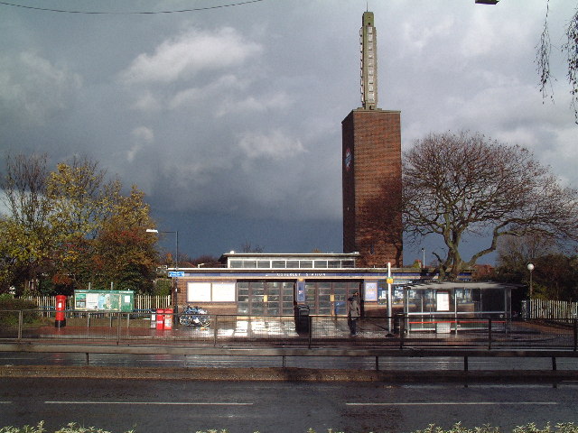


Osterley, United Kingdom
Osterley is a town of 13,031 people in England, United Kingdom.
Why visit Osterley
Townapedia lists 24 museums and landmarks, 46 parks and trails, 184 places to eat, 9 places to stay and 14 attractions in and around town.
Highlights include Kew Bridge, London Butterfly House, Osterley House and Boston Manor.
Weather in Osterley
Forecast from MET Norway (CC BY 4.0). Full forecast
About Osterley
Osterley is a district of Isleworth in west London, England, 8.7 miles (14.0 km) from Charing Cross in the London Borough of Hounslow. Most of its land use is mixed agricultural and aesthetic parkland at Osterley House (National Trust), charity-run, much of which is open to paying visitors.
From the Wikipedia article Osterley (this version), under CC BY-SA 4.0.
Things to do14


London Butterfly House
Zoo and aquarium · 1.6 mi
Zoo in Middlesex, England

Q Theatre
Cinema and theater · 3.0 mi
Former theatre and cinema in Chiswick, Hounslow, London, England

Richmond Bridge
Bridge · 2.6 mi
18th-century bridge in London, England

Richmond Lock and Footbridge
Bridge · 2.0 mi
Lock and pedestrian bridge, situated on the River Thames in south west London

Richmond Railway Bridge
Bridge · 2.2 mi
Grade II listed steel bridge in London Borough of Richmond upon Thames, United Kingdom

Richmond Theatre
Cinema and theater · 2.3 mi
Theatre in Richmond 1765–1884

The Exchange, Twickenham
Cinema and theater · 2.3 mi
Theatre and arts venue in the London Borough of Richmond upon Thames


Watermans
Cinema and theater · 2.4 mi
Arts centre including a theatre and cinemas in Brentford, Hounslow, London, England

Windmill Bridge
Bridge · 1.7 mi
Also known as 'The Three Bridges'. Designed by Isambard K Brunel. Road, rail and canal intersect at this bridge.

Kew Railway Bridge
Bridge · 3.2 mi
Bridge across the River Thames in London, UK
2 more on the map.
Museums and landmarks24

Osterley House
Museum · 0.6 mi
Historic house museum in London
Jersey Road, Isleworth

Boston Manor
Museum · 1.7 mi
Historic house museum in Brentford, London, UK

Ham House
Museum · 3.0 mi
Historic house museum in Ham, London Borough of Richmond upon Thames, England, UK

Kew Palace
Museum · 2.5 mi
Grade I listed historic house museum in London Borough of Richmond upon Thames, United Kingdom

Kilmorey Mausoleum
Monument and historic site · 1.9 mi
Mausoleum in St Margarets, London

London Museum of Water and Steam
Museum · 2.8 mi
Museum in London, United Kingdom

Musical Museum
Museum · 2.7 mi
Music museum in London, United Kingdom

Orleans House Gallery
Museum · 2.7 mi
Building and art gallery in Twickenham, London Borough of Richmond upon Thames, England, United Kingdom

Pope's Urn
Monument and historic site · 2.6 mi
Memorial to Alexander Pope in Twickenham, London

Strawberry Hill House
Museum · 3.0 mi
Villa and house museum in Twickenham, London, United Kingdom

Syon House
Museum · 1.8 mi
House with park in Isleworth, west London, England, UK

The Queen's Cottage
Museum · 2.2 mi
Historic house in Kew Gardens, London
12 more on the map.
Parks, trails and playgrounds46


Crane Meadows
Park · 2.7 mi
Nature reserve in London, England, United Kingdom


Crane Park Island
Park · 2.8 mi
Island in the London Borough of Richmond upon Thames, England, UK



Warren Farm Nature Reserve
Hiking and trails · 1.4 mi
Reccognised as a local nature reserve by Brent River and canal society or Brent River Parks. A species diverse meadow rewilded.
Windmill Lane, Southall
24/7

Cranford Park
Park · 2.7 mi
Park in London Borough of Hillingdon, United Kingdom
34 more on the map.
Restaurants and cafes184
Hala Garden
Restaurant · Lebanese · 0.8 mi
50 Hanworth Road, Hounslow
Su-Th 14:00-23:59; Fr-Sa 14:00-01:00



Restaurant Carpatica
Restaurant · 1.0 mi
34
Mo-Th 12:00-22:00; Fr 12:00-23:00; Sa 11:00-00:00; Su 11:00-22:00
The Moon Under Water
Bar and pub · 1.1 mi
84-86 Staines Road, Hounslow
Mo,Tu,We,Th,Fr,Sa,Su 08:00-24:00

Captain Hooks Fish & Chips
Restaurant · Kebab, Burger, Chicken, Fish And Chips · 0.8 mi
13 St. John's Road
Mo-Fr 17:00-21:30; Sa-Su 12:00-21:30
172 more on the map.
Notable people from Osterley
- Ian McDonaldEnglish musician, co-founder of King Crimson and Foreigner (1946–2022)
- Annie NightingaleEnglish radio and television broadcaster (1940–2024)
- Bobby GoldthorpeEnglish footballer (born 1950)
Born in Osterley, according to Wikidata (CC0). Each name links to its Wikipedia article.
Where to stay9
Churches and places of worship73
Shopping28
Gas and EV charging7
Schools, colleges and libraries49
St. Michael and St. Martin Catholic Primary School
School · Roman Catholic · 1.4 mi
Belgrave Road, Hounslow
Healthcare18
Heart of Hounslow Centre for Health
Clinic and pharmacy · 1.1 mi
92 Bath Road, Hounslow
Jade Pharmacy & Travel Clinic
Clinic and pharmacy · 1.1 mi
3 Crosslands Ave, Hounslow, Southall, Southall
Map of Osterley
250 places. The map loads OpenStreetMap tiles when you open it.
Getting there and nearby towns
Heathrow Airport (LHR) is the nearest airport with scheduled flights listed in OpenStreetMap, 4 miles away.
- Isleworth 1 mi southeast, about 1 min by car
- Brentford 2 mi east, about 3 min by car
- Richmond 2 mi southeast, about 4 min by car
- Cranford 3 mi west, about 4 min by car
- West Ealing 3 mi northeast, about 4 min by car
- Kew 3 mi east, about 5 min by car
- Hanworth 3 mi south, about 6 min by car
- Barnes 5 mi east, about 7 min by car
- Hampton 5 mi south, about 7 min by car
- Northolt 5 mi north, about 8 min by car
Drive times are estimates from straight-line distance, not routes.
Towns near Osterley


Keep exploring
Local news
Headlines from INDB.
Reviews, tips and questions
Loading what members have shared...
Sources and licences
- GeoNames (CC BY 4.0): population, coordinates, regions and time zone
- Mapillary (see each image): photos
- OpenStreetMap contributors (ODbL 1.0): places, airports, map data
- Wikidata (CC0 1.0): elevation, founding date, time zone, website, landmarks and historic places
- Wikimedia Commons (see each image): photos
- Wikipedia (CC BY-SA 4.0): overview and history text
Photo credits
- Osterley tube Station, David Squire, CC BY-SA 2.0
- Osterley tube station (80291), Rc1959, CC0
- Osterley tube station (13635), Rc1959, CC0
- Osterley Park House, London-25June2009-rc, Osterley Park House, London-25June2009.jpg : Jim Linwood derivative work: Snowmanradio ( talk ), CC BY 2.0
- Kew Bridge in London 2007 Sept 21, Patche99z, CC BY 3.0
- Richmond 018 Richmond Bridge TT panorama, Amandajm, CC BY-SA 3.0
- Richmond Lock from Isleworth,Middx looking SE, Unknown author, CC BY-SA 3.0
- Richmond Railway Bridge 333r1, Patche99z, CC BY 3.0
- Second Richmond Theatre (1765-1884), Unknown author Unknown author, Public domain
- The Exchange, Twickenham, Robert Smith, CC BY-SA 4.0
- Twickenham Bridge312-315b, Patche99z, CC BY 3.0
- Brunel's road, canal and rail bridge (Three Bridges), Smeashy, CC BY-SA 4.0
- Boston manor front 2943, P.g.champion, CC BY-SA 2.0 uk
- Ham House, London, Stevekeiretsu, CC BY-SA 4.0
- Kew Palace (5942717068), xlibber, CC BY 2.0
- Entrance to The Kilmorey Mausoleum, Maxwell Hamilton, CC BY 2.0
- London Museum of Water & Steam entrance, Smurfy, CC0
- The Musical Museum, Brentford, London., Jim Linwood, CC BY 2.0
- Orleans House Gallery, Matt Brown, CC BY 2.0
- Pope's Urn, Twickenham, Robert Smith, CC BY-SA 4.0
- Strawberry Hill House from garden in 2012 after restoration, Chiswick Chap, CC BY-SA 3.0
- Syon House West Aspect, Russ Hamer, CC BY-SA 3.0
- Kew Gardens Queen Charlottes Cottage, Prl42, CC BY-SA 3.0
- Blondin Park nature reserve 6, Dudley Miles, CC BY-SA 3.0
- Flickr - law keven - On a Cold ^ Frosty Morning...., Keven Law from Los Angeles, USA, CC BY-SA 2.0
- River Crane in Crane Park 2, Dudley Miles, CC BY-SA 3.0
- Crane Park Island Nature Reserve, Twickenham, London. (3350016620), Jim Linwood from London, CC BY 2.0
- Pevensey Road Nature Reserve 3, Dudley Miles, CC BY-SA 3.0
- All Hallows Parish Church in Twickenham, Maxwell Hamilton, CC BY 2.0
- Chapel in the Wood, Strawberry Hill 01, Jonathan Cardy, CC BY-SA 4.0
- Grove Gardens Chapel northwest, Cewjones01, CC BY-SA 4.0
- Royal College Of Midwives Picket The West Middlesex Hospital, Isleworth - London, Jim Linwood from London, CC BY 2.0
- Butterfly at Syon House, Keven Law from Los Angeles, USA, CC BY-SA 2.0
- Beatrice Lewisohn Q theatre programme 1935, Unknown author Unknown author, Public domain
- Isleworth, Gumley House, AndyScott, CC BY-SA 4.0
- Cranebank path, Dudley Miles, CC BY-SA 3.0
- Long Wood, Norwood Green 1, Dudley Miles, CC BY-SA 3.0
- Crane Meadows, JoshuaAnthonyGill, CC BY-SA 4.0
- Treaty Centre entrance, Hounslow High Street, Maxwell Hamilton, CC BY 2.0
- The Riverside Promenade in Waterman's Park in Brentford - panoramio, Maxwell Hamilton, CC BY-SA 3.0
- Hounslow Heath Panorama1443, Patche99z, CC BY-SA 3.0
- St Anne Kew Green 4879crop, Patche99z, CC BY-SA 3.0
- Street-level photo, laye, CC BY-SA 4.0
- Street-level photo, milhouse, CC BY-SA 4.0
- Street-level photo, southglos, CC BY-SA 4.0
- Street-level photo, laye, CC BY-SA 4.0
- Street-level photo, geoengtechel, CC BY-SA 4.0
- Street-level photo, milhouse, CC BY-SA 4.0
- Street-level photo, milhouse, CC BY-SA 4.0
- Street-level photo, laye, CC BY-SA 4.0
- Street-level photo, laye, CC BY-SA 4.0
- Street-level photo, laye, CC BY-SA 4.0
- Street-level photo, milhouse, CC BY-SA 4.0
- Street-level photo, milhouse, CC BY-SA 4.0
- Street-level photo, caranteth, CC BY-SA 4.0
- Street-level photo, RyanBush, CC BY-SA 4.0
- Street-level photo, alexanderar, CC BY-SA 4.0
- Street-level photo, jethro10, CC BY-SA 4.0
- Street-level photo, jethro10, CC BY-SA 4.0


Page built November 10, 2026. Spotted a mistake? Tell us or suggest a place.