
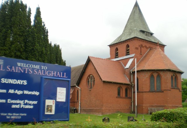


Why visit Saughall
Townapedia lists 5 museums and landmarks, 4 parks and trails, 7 places to eat, 4 places to stay and 1 attraction in and around town.
Highlights include Hawarden Bridge, Water Tower, Chester, Chester Zoo and Countess of Chester Country Park.
Weather in Saughall
Forecast from MET Norway (CC BY 4.0). Full forecast
About Saughall
Saughall is a village in the civil parish of Saughall and Shotwick Park, in the unitary authority area of Cheshire West and Chester and the ceremonial county of Cheshire, England. Located between Shotwick and Blacon, it is approximately 3 miles (4.8 km) north west of Chester and 1 mile (1.6 km) from Sealand across the Welsh border.
From the Wikipedia article Saughall (this version), under CC BY-SA 4.0.
Photos of Saughall


Things to do1

Museums and landmarks5



Parks, trails and playgrounds4

Chester Zoo
Park · 3.0 mi
Zoological garden at Upton-by-Chester, in Cheshire, England

Countess of Chester Country Park
Park · 2.6 mi
Country park in Upton, Cheshire, England


Restaurants and cafes7


History
The Domesday Book of 1086 mentions the village as Salhale. Most of the land is recorded as in the possession of a Norman baron, William Malbank (or Malbanc). The remainder was held by St Werburgh Abbey in Chester.
Saughall was a fishing village until it was cut off from the sea by land reclamation in the Dee estuary. The river had flowed to the sea along the current border between Wales and England, until in the 18th century, when it was diverted into its present channelised course to try to improve ship access from the sea to Chester.
The village previously consisted of two townships in the parish of Shotwick, Wirral Hundred. Great Saughall had a population of 147 in 1801, 493 in 1851 and 703 in 1901.
Little Saughall had a population of 48 in 1801, 69 in 1851 and 137 in 1901.
The civil parish of Saughall was created on 1 April 1948 by uniting both settlements, with a combined population of 1,518 in 1951. The civil parish was abolished on 1 April 2015 to form Saughall and Shotwick Park, with parts also incorporated into the parish of Puddington and the unparished area of Chester.
Between 31 March 1890 and 1 February 1954, Saughall railway station on the Chester & Connah's Quay Railway served the village. The station has been demolished, and the trackbed is now a cycleway.
From the History section of Saughall on Wikipedia, under CC BY-SA 4.0.
Notable people from Saughall
- John Wrightgreyhound trainer, born 1899
Born in Saughall, according to Wikidata (CC0). Each name links to its Wikipedia article.
Where to stay4
Chester Crabwall Manor Hotel and Spa
Motel and hotel · 1.5 mi
Parkgate Road, Chester
Churches and places of worship14
Gas and EV charging1
Schools, colleges and libraries3
Healthcare1
Map of Saughall
40 places. The map loads OpenStreetMap tiles when you open it.
Getting there and nearby towns
Hawarden Airport (CEG) is the nearest airport with scheduled flights listed in OpenStreetMap, 3 miles away.
- Blacon 2 mi southeast, about 3 min by car
- Chester 4 mi southeast, about 6 min by car
- Deeside 4 mi southwest, about 6 min by car
- Hawarden 4 mi southwest, about 7 min by car
- Ellesmere Port Town 4 mi northeast, about 7 min by car
- Hoole 4 mi southeast, about 6 min by car
- Willaston 5 mi north, about 8 min by car
- Mickle Trafford 5 mi east, about 8 min by car
- Neston 6 mi northwest, about 9 min by car
- Buckley 7 mi southwest, about 11 min by car
Drive times are estimates from straight-line distance, not routes.
Towns near Saughall


Keep exploring
Local news
Headlines from INDB.
Reviews, tips and questions
Loading what members have shared...
Sources and licences
- GeoNames (CC BY 4.0): population, coordinates, regions and time zone
- Mapillary (see each image): photos
- OpenStreetMap contributors (ODbL 1.0): places, airports, map data
- Wikidata (CC0 1.0): elevation, founding date, time zone, website, landmarks and historic places
- Wikimedia Commons (see each image): photos
- Wikipedia (CC BY-SA 4.0): overview and history text
Photo credits
- Saughall, R lee, CC BY-SA 2.0
- All Saints Church, Saughall, Jeff Buck, CC BY-SA 2.0
- Aldersey House, Saughall 03, Dave.Dunford, CC BY-SA 4.0
- Aldersey House, Saughall 02, Dave.Dunford, CC BY-SA 4.0
- Aldersey House, Saughall 01, Dave.Dunford, CC BY-SA 4.0
- Shotwick House, Saughall, Dave.Dunford, CC BY-SA 4.0
- Chester Zoo 2016 010 - Islands, Photograph by Mike Peel ( www.mikepeel.net )., CC BY-SA 4.0
- Chapel at the Countess of Chester Hospital (27624), Bugsybanana, CC BY-SA 4.0
- University of Chester Chapel, Georgemorris94, CC BY-SA 3.0
- Holy Trinity Church, Capenhurst 01, Rodhullandemu, CC BY-SA 4.0
- St Matthew's Church, Saltney, John S Turner, CC BY-SA 2.0
- St Michael's Church, Shotwick 2, Rept0n1x, CC BY-SA 3.0
- St Oswald's Church, Backford (4), Rept0n1x, CC BY-SA 3.0
- Mission Church, D71b3a, CC BY 3.0
- Nephrotoma quadrifaria 289058724, osianshirley, CC BY 4.0
- Nekrolog z czasopisma, Cienkus Ryszard, CC BY-SA 4.0
- Podpułkownik na koniu, Cienkus Ryszard, CC BY-SA 4.0
- Hawarden Bridge Station, Dennis Turner, CC BY-SA 2.0
- Shotwick Castle, John Hughes, CC BY-SA 2.0
- Street-level photo, RyanBush, CC BY-SA 4.0
- Street-level photo, RyanBush, CC BY-SA 4.0
- Street-level photo, RyanBush, CC BY-SA 4.0
- Street-level photo, RyanBush, CC BY-SA 4.0
- Street-level photo, RyanBush, CC BY-SA 4.0
- Street-level photo, RyanBush, CC BY-SA 4.0


Page built November 10, 2026. Spotted a mistake? Tell us or suggest a place.