


Stainburn, United Kingdom
Stainburn is a town of 1,666 people in England, United Kingdom.
Why visit Stainburn
Townapedia lists 3 museums and landmarks, 3 places to eat and 8 attractions in and around town.
Highlights include Almscliffe Crag and Leathley Hall.
Weather in Stainburn
Forecast from MET Norway (CC BY 4.0). Full forecast
About Stainburn
Stainburn is a village and civil parish in the county of North Yorkshire, England, 10 miles (16 km) north of Leeds. The population of the civil parish was estimated at 120 in 2015.
From the Wikipedia article Stainburn, North Yorkshire (this version), under CC BY-SA 4.0.
Things to do8

Almscliffe Crag
Scenic view · 1.0 mi
Local landmark rock outcrop and lesiure destination

Museums and landmarks3

camp
Monument and historic site · 1.5 mi
Originally mapped in C19th but there is no modern record such as Historic England listing
Restaurants and cafes3

Churches and places of worship7
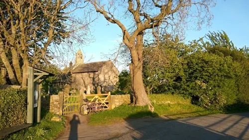

Church of St Michael and All Angels, Beckwithshaw
Church · 3.0 mi
Church in Pannal, Pannal and Burn Bridge, Harrogate, England, UK

Church of St Oswald
Church · 1.6 mi
Grade I listed church in Leathley, North Yorkshire, England, UK
St Mary's Church, Stainburn
Church
Grade I listed church in Stainburn, Harrogate, North Yorkshire, England, UK

Church of All Saints
Church · 2.5 mi
Church building in Farnley, Harrogate, North Yorkshire, England, UK
Church of St Barnabas
Church · 2.3 mi
Church in Weeton, Harrogate, North Yorkshire, England, UK
History
The name 'Stainburn' is derived from the Old English and means "Stone Stream", suggesting the village suffered a lack of fresh water supplies, many centuries ago.
Stainburn is recorded in the Domesday Book in 1086: "King William was the Lord of Stainburn", and the "Tenant-in-chief was also King William" "In 1066 the value to the Lord was £2 with a taxeable value of 5 geld units".
In 1848, Stainburn was a village with houses distributed all around the Norman style chapel. It consisted of:
"2900 acres of land alongside the property of F. H. Fawkes, Esq., lord of the manor. Whilst the land was considered valuable for cultivation, the tithes were introduced for land purposes within the religious organisation. Bequests (acts of giving) were implemented for the poor people of the village".
Stainburn was historically a township in the parish of Kirkby Overblow in the West Riding of Yorkshire. In the 1870s it was described as:
"a township-chapelry, with two hamlets, in Kirkby-Overblow parish, W. R. Yorkshire; near Weeton railway station, and 4 miles NE by E of Otley; where there is a parochial school".
The village was transferred to the new county of North Yorkshire in 1974. From 1974 to 2023 it was part of the Borough of Harrogate, it is now administered by the unitary North Yorkshire Council.
From the History section of Stainburn, North Yorkshire on Wikipedia, under CC BY-SA 4.0.
Gas and EV charging1
Map of Stainburn
22 places. The map loads OpenStreetMap tiles when you open it.
Getting there and nearby towns
Leeds Bradford Airport (LBA) is the nearest airport with scheduled flights listed in OpenStreetMap, 5 miles away.
- Otley 4 mi southwest, about 6 min by car
- Harrogate 5 mi northeast, about 8 min by car
- Yeadon 6 mi southwest, about 9 min by car
- Guiseley 6 mi southwest, about 9 min by car
- Horsforth 6 mi south, about 10 min by car
- Chapel Allerton 8 mi southeast, about 13 min by car
- Knaresborough 8 mi northeast, about 13 min by car
- Ilkley 8 mi west, about 14 min by car
- Shipley 9 mi southwest, about 15 min by car
- Leeds 10 mi south, about 16 min by car
Drive times are estimates from straight-line distance, not routes.
Towns near Stainburn


Keep exploring
Local news
Headlines from INDB.
Reviews, tips and questions
Loading what members have shared...
Sources and licences
- GeoNames (CC BY 4.0): population, coordinates, regions and time zone
- Mapillary (see each image): photos
- OpenStreetMap contributors (ODbL 1.0): places, airports, map data
- Wikidata (CC0 1.0): elevation, founding date, time zone, website, landmarks and historic places
- Wikimedia Commons (see each image): photos
- Wikipedia (CC BY-SA 4.0): overview and history text
Photo credits
- Young man at Stainburn Rocks (Unsplash), Jenny Hill jennyhill, CC0
- Beckwithshaw Church 034, Storye book, CC BY 3.0
- The Parish Church of St Oswald, Leathley, Alexander P Kapp, CC BY-SA 2.0
- Almscliffe crag1, Coolug, CC BY 3.0
- Street-level photo, mapz4lolz, CC BY-SA 4.0
- Street-level photo, mackerski, CC BY-SA 4.0
- Street-level photo, mackerski, CC BY-SA 4.0
- Street-level photo, mackerski, CC BY-SA 4.0
Page built November 10, 2026. Spotted a mistake? Tell us or suggest a place.