
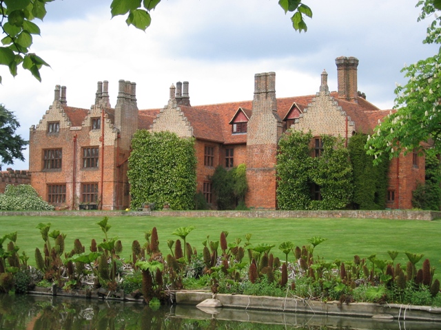


Why visit Stock
Townapedia lists 3 museums and landmarks, 7 parks and trails, 8 places to eat and 1 place to stay in and around town.
Highlights include Hylands, Ingatestone Hall, Crowsheath Wood and Hanningfield Reservoir.
Weather in Stock
Forecast from MET Norway (CC BY 4.0). Full forecast
About Stock
Stock is a village and civil parish in the City of Chelmsford district of Essex, England. It lies about 6 miles (10 km) south of Chelmsford (the county town) and about 2.5 miles (4.0 km) north of Billericay. At the 2021 census, the parish had a population of 2,156.
From the Wikipedia article Stock, Essex (this version), under CC BY-SA 4.0.
Museums and landmarks3


Parks, trails and playgrounds7



Galleywood Common
Park · 2.2 mi
Common in Galleywood, Chelmsford, Essex
Norsey Wood
Park · 2.2 mi
Woodland nature reserve in Billericay, Essex

Restaurants and cafes8


Where to stay1

History
The origins of the village are uncertain and are subject to debate. Archaeological finds suggest that there was a settlement on the site during the Iron Age period. The Domesday Book of 1086, however, does not mention Stock.
The first documentary evidence of the settlement dates from the 13th century. Until the 16th century, the village was known as Hereward Stock, Stoke or variations thereof.
Stock historically formed part of the ancient parish of Buttsbury, which had its parish church of St Mary's in an isolated location at the western edge of the parish. From at least the 12th century, there was a chapel of ease dedicated to All Saints at Stock. Stock was more central to the parish and, by medieval times, had become the main village in Buttsbury parish. The chapelry of Stock subsequently became a separate parish. The area ceded to the new parish of Stock was relatively small, with north-eastern parts of the built up area of Stock around the High Street remaining in Buttsbury, forming part of a long salient which skirted around the northern edge of the village. As late as the 19th century, this area around Stock's High Street was where most of the houses in Buttsbury parish were located; the built up area was sometimes described as being Stock and Buttsbury intermingled.
Read more of the history
The civil parish of Stock was enlarged in 1881 to take in the Crondon area north of the village, which had been a detached part of the parish of Orsett. It was further enlarged in 1936 when the parish of Buttsbury was abolished, thereby gaining the remaining parts of Stock village and the rural area to the west around the church. In 1955, the parish also gained rural areas to the east of the village from South Hanningfield and West Hanningfield.
From the History section of Stock, Essex on Wikipedia, under CC BY-SA 4.0.
Notable people from Stock
- Hugh HaggardRoyal Navy officer
Born in Stock, according to Wikidata (CC0). Each name links to its Wikipedia article.
Churches and places of worship6
Gas and EV charging1
Schools, colleges and libraries2
Map of Stock
28 places. The map loads OpenStreetMap tiles when you open it.
Getting there and nearby towns
London Southend Airport (SEN) is the nearest airport with scheduled flights listed in OpenStreetMap, 12 miles away.
- Billericay 3 mi south, about 4 min by car
- Chelmsford 5 mi north, about 8 min by car
- Wickford 5 mi southeast, about 8 min by car
- Basildon 7 mi south, about 11 min by car
- Brentwood 7 mi southwest, about 11 min by car
- Pitsea 7 mi south, about 12 min by car
- Rayleigh 9 mi southeast, about 14 min by car
- South Benfleet 9 mi southeast, about 15 min by car
- Stanford-le-Hope 10 mi south, about 16 min by car
- Hadleigh 10 mi southeast, about 17 min by car
Drive times are estimates from straight-line distance, not routes.
Towns near Stock


Keep exploring
Local news
Headlines from INDB.
Reviews, tips and questions
Loading what members have shared...
Sources and licences
- GeoNames (CC BY 4.0): population, coordinates, regions and time zone
- OpenStreetMap contributors (ODbL 1.0): places, airports, map data
- Wikidata (CC0 1.0): elevation, founding date, time zone, website, landmarks and historic places
- Wikimedia Commons (see each image): photos
- Wikipedia (CC BY-SA 4.0): overview and history text
Photo credits
- IngatestoneHall(JohnSTurner)May2003, John S Turner, CC BY-SA 2.0
- Crowsheath Wood 1, Dudley Miles, CC BY-SA 4.0
- Hanningfield Reservoir (1878006637), Michael Bridgen from London, United Kingdom, CC BY-SA 2.0
- Stock War Memorial east, Piecesofuk, CC BY-SA 4.0
- Hylands House, Graham Richter, CC BY-SA 3.0
Page built November 10, 2026. Spotted a mistake? Tell us or suggest a place.