
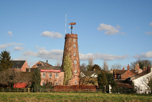


Wainfleet All Saints, United Kingdom
Wainfleet All Saints is a town of 1,744 people in England, United Kingdom.
Why visit Wainfleet All Saints
Townapedia lists 1 museum or landmark and 12 places to eat in and around town.
Weather in Wainfleet All Saints
Forecast from MET Norway (CC BY 4.0). Full forecast
About Wainfleet All Saints
Wainfleet All Saints is a market town and civil parish in the East Lindsey district of Lincolnshire, England. It is located on the A52 road, 5 miles (8 km) south-west of Skegness and 14 miles (23 km) north-east of Boston. It stands on two small rivers, the Steeping and Limb (or Lymn), that form Wainfleet Haven. The town is close to the Lincolnshire Wolds.
From the Wikipedia article Wainfleet All Saints (this version), under CC BY-SA 4.0.
Photos of Wainfleet All Saints

Museums and landmarks1

Restaurants and cafes12




Churches and places of worship4


Shopping1

History
The name "Wainfleet" is derived from Wegn fleot, a stream that can be crossed by a wagon (compare with 'wainwright', a maker of wagons). The town stands on or near the former Roman settlement of Vainona. Two tumuli, one to the north and one to the south of the town, are of unknown origin, although it has been suggested that they could be Viking or Roman. A number of coins from the period have been found in the vicinity. In the Domesday Book of 1086, Wainfleet is referred to as 'Wenflet'.
From the History section of Wainfleet All Saints on Wikipedia, under CC BY-SA 4.0.
More about Wainfleet All Saints
Geography
Wainfleet is located south of Skegness and north of Boston on the A52.
Work on the A52 bypass started in February 1990, costing £1.82m. Construction took 60 weeks, being built by Lincway Construction, a division of the county council, The bypass opened in February 1991.
Education
Skegness Grammar School has a boarding house in the town on Low Road.
The town was at the end of a branch of the Great Northern Railway until the development of Skegness about 6 miles (10 km) to the east. Wainfleet railway station is on Station Road, and is on the Nottingham to Skegness Line.
Meetings of the Motorcycle Grasstrack Racing are hosted by the Wainfleet & District Sporting Motorcycle Club. They have run annually the International Lincolnshire Poacher race since 1992.
The club have also hosted the British Masters Championship on four occasions in 1997, 1998, 2002, 2004. In 2011 the club hosted the European Grasstrack Championship Final at their home at Thorpe St Peter.
From the Wikipedia article Wainfleet All Saints, under CC BY-SA 4.0.
Notable people from Wainfleet All Saints
- William WaynfleteLord Chancellor of England; Bishop of Winchester
Born in Wainfleet All Saints, according to Wikidata (CC0). Each name links to its Wikipedia article.
Schools, colleges and libraries2
Healthcare1
Map of Wainfleet All Saints
21 places. The map loads OpenStreetMap tiles when you open it.
Getting there and nearby towns
RAF Coningsby (QCY) is the nearest airport with scheduled flights listed in OpenStreetMap, 17 miles away.
- Skegness 5 mi northeast, about 8 min by car
- Boston 14 mi southwest, about 23 min by car
- Mablethorpe 16 mi north, about 26 min by car
- Louth 21 mi northwest, about 33 min by car
- King's Lynn 25 mi south, about 41 min by car
- Wragby 25 mi northwest, about 41 min by car
- Spalding 27 mi southwest, about 44 min by car
- Sleaford 28 mi west, about 45 min by car
- Wisbech 31 mi south, about 49 min by car
- Lincoln 33 mi west, about 53 min by car
Drive times are estimates from straight-line distance, not routes.
Towns near Wainfleet All Saints


Keep exploring
Local news
Headlines from INDB.
Reviews, tips and questions
Loading what members have shared...
Sources and licences
- GeoNames (CC BY 4.0): population, coordinates, regions and time zone
- Mapillary (see each image): photos
- OpenStreetMap contributors (ODbL 1.0): places, airports, map data
- Wikidata (CC0 1.0): elevation, founding date, time zone, website
- Wikimedia Commons (see each image): photos
- Wikipedia (CC BY-SA 4.0): overview and history text
Photo credits
- Wainfleet, Salem Bridge Mill, Richard Croft, CC BY-SA 2.0
- 156470 arrives at Wainfleet with a service from Skegness to Nottingham - 36257471450, kitmasterbloke, CC BY 2.0
- 156470 arrives at Wainfleet with a service from Skegness to Nottingham 2, kitmasterbloke, CC BY 2.0
- Wainfleet Signal Box, Lincolnshire - 36484528692, kitmasterbloke, CC BY 2.0
- Wainfleet Signal Box, Lincolnshire, kitmasterbloke, CC BY 2.0
- Wainfleet Signal Box, Lincolnshire - 36257467750, kitmasterbloke, CC BY 2.0
- 156470 arrives at Wainfleet with a service from Skegness to Nottingham, kitmasterbloke, CC BY 2.0
- Street-level photo, hodg, CC BY-SA 4.0
Page built November 10, 2026. Spotted a mistake? Tell us or suggest a place.