


Why visit Wantage
Townapedia lists 18 museums and landmarks, 24 parks and trails, 52 places to eat, 2 places to stay and 1 attraction in and around town.
Highlights include Vale and Downland Museum and Visitor Centre, The Sack House and Letcombe Valley.
Weather in Wantage
Forecast from MET Norway (CC BY 4.0). Full forecast
About Wantage
Wantage () is a historic market town and civil parish at the foot of the Berkshire Downs in the Vale of White Horse, Oxfordshire, England. Historically in Berkshire, it has been administered as part of Oxfordshire since 1974. The town is on Letcombe Brook, 8 miles (13 km) south-west of Abingdon, 14 miles (23 km) north-west of Newbury, and 15 miles (24 km) south-west of Oxford.
From the Wikipedia article Wantage (this version), under CC BY-SA 4.0.
Travel tips from other travellers: Wantage on Wikivoyage (CC BY-SA 4.0).
Things to do1

Museums and landmarks18

Vale and Downland Museum and Visitor Centre
Museum
19 Church Street, Wantage
Mo-Sa 09:30-15:45
Vale and Downland Museum
Museum
Museum of local culture and history in Oxfordshire, England, United Kingdom


Wellington Gate
Monument and historic site · 1.2 mi
A large wall plaque depicting a fighter plane and the development name, to recognize the old Grove Airfield
Wilts & Berks Canal
Monument and historic site · 1.2 mi
Historic route of the Wilts and Berks Canal - This part of the canal has been built over
Wilts & Berks Canal (historical)
Monument and historic site · 0.5 mi
Historic route of the Wantage branch of the Wilts & Berks Canal
6 more on the map.
Parks, trails and playgrounds24



12 more on the map.
Restaurants and cafes52

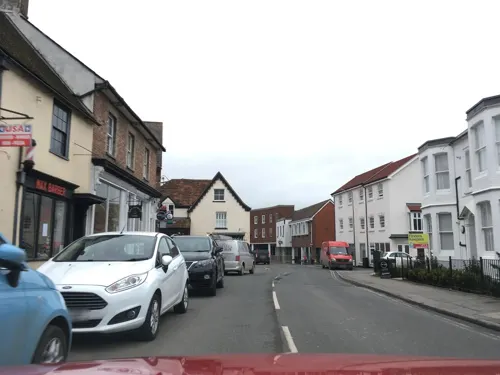
Peking Dynasty
Restaurant · Chinese
Newbury Street, Wantage
Tu-Th,Su 17:00-21:00; Mo closed; Sa 17:00-21:30



40 more on the map.
History
Wantage was a small Roman settlement but the origin of the toponym is somewhat uncertain. It was seemingly named after a stream that was there originally, with possible etymology being 'to wane, decrease' or an intermittent stream. King Alfred the Great was born at the royal palace there in the 9th century, in what was originally known as Wanating. Wantage appears in the Domesday Book of 1086. Its value was £61 and it was in the king's ownership until Richard I passed it to the Earl of Albemarle in 1190. Weekly trading rights were first granted to the town by Henry III in 1246. Markets are now held twice weekly on Wednesdays and Saturdays. Royalist troops were stationed in Wantage during the English Civil War.
Read more of the history
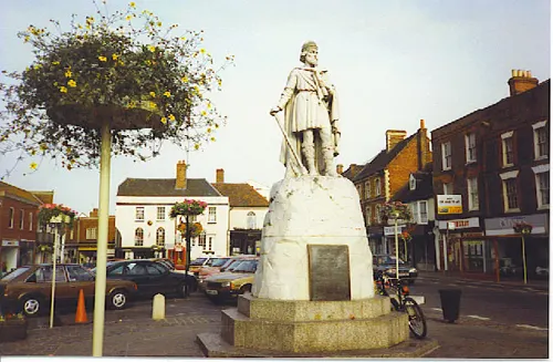
In the 19th century, Lord Wantage became a notable local and national benefactor. He was very involved in founding the British Red Cross Society. In 1877 he paid for a marble statue of King Alfred by Count Gleichen to be erected in Wantage market place, where it still stands today. He also donated the Victoria Cross Gallery to the town. This contained paintings by Louis William Desanges depicting deeds which led to the award of a number of VCs, including his own gained during the Crimean War. It is now a shopping arcade. Wantage is home to the Community of Saint Mary the Virgin, founded by the vicar of Wantage William John Butler in 1848; it was once one of the largest communities of Anglican nuns in the world. Wantage once had two breweries which were taken over by Morlands of Abingdon. In 1988 the town was thrust into the headlines after a Brass Tacks programme entitled "Shire Wars" exposed the drunken violence that plagued the town and surrounding villages at that time.
From the History section of Wantage on Wikipedia, under CC BY-SA 4.0.
More about Wantage
Geography
Wantage is at the foot of the Berkshire Downs escarpment in the Vale of the White Horse. There are gallops at Black Bushes and nearby villages with racing stables at East Hendred, Letcombe Bassett, Lockinge and Uffington. Wantage includes the suburbs of Belmont to the west and Charlton to the east. Grove to the north is still just about detached and is a separate parish. Wantage parish stretches from the northern edge of its housing up onto the Downs in the south, covering Chain Hill, Edge Hill, Wantage Down, Furzewick Down and Lattin Down. The Edgehill Springs rise between Manor Road and Spike Lodge Farms and the Letcombe Brook flows through the town. Wantage is home to the Vale and Downland Museum. There is a large market square containing a statue of King Alfred, surrounded by shops some with 18th-century facades. Quieter streets radiate from it, including one towards the large Church of England parish church. Wantage is the "Alfredston" of Thomas Hardy's Jude the Obscure.
Education
There is one state secondary school in Wantage, King Alfred's Academy, and approximately ten primary schools. The secondary school converted into an academy in 2011 and was rated Outstanding by Ofsted in that year.
Between 1873 and 2006, an Anglican private girls' school, St Mary's School, was located in Wantage. The school closed in 2006 when St. Mary's merged with Heathfield School, Ascot. A former independent preparatory school, St Andrew's, established in 1926, closed permanently in 2010.
Fitzwaryn School, a school catering for children with special needs aged 3–19, is situated in Wantage. The school was rated Outstanding by Ofsted in 2014. It is named after the ancient lords of the manor of Wantage, the FitzWarin family, powerful Marcher Lords seated at Whittington Castle in Shropshire.
From the Wikipedia article Wantage, under CC BY-SA 4.0.
Notable people from Wantage
 Edward the Elderking of the Anglo-Saxons (r. 899–924)Photo: Unknown author Unknown author, Public domain
 Frances O'ConnorAustralian actressPhoto: Robert Connolly, CC BY-SA 2.0
 Mike Parker PearsonEnglish archaeologistPhoto: H-stt, CC BY-SA 4.0
 Caroline VoadenBritish politician and journalist (born 1968)Photo: ©House of Commons, CC BY 3.0
 Theodore Andrea CookBritish writer (1867–1928)Photo: photographers: Elliott & Fry, Public domain
 Nick BoyleAmerican football playerPhoto: Jeffrey Beall, CC BY 3.0
- Alfred the Greatking of Wessex (r. 872–901)
- Joseph ButlerEnglish bishop and philosopher (1692–1752)
- Lester PiggottBritish champion jockey (1935–2022)
- Roy BurtonEnglish footballer (born 1951)
- John HarrisBritish politician (1874-1940), anti-slavery campaigner
- Edward CawstonEnglish cricketer (1911-1998)
Born in Wantage, according to Wikidata (CC0). Each name links to its Wikipedia article.
Where to stay2
Churches and places of worship11
Shopping11
Gas and EV charging2
Schools, colleges and libraries14
Healthcare8
Wantage Osteopathic Practice and Sports Injury Clinic
Clinic and pharmacy
1-2 Church Street, Wantage
Map of Wantage
143 places. The map loads OpenStreetMap tiles when you open it.
Getting there and nearby towns
RAF Brize Norton (BZZ) is the nearest airport with scheduled flights listed in OpenStreetMap, 13 miles away.
- Oxford 13 mi northeast, about 22 min by car
- Witney 14 mi north, about 22 min by car
- Swindon 15 mi west, about 25 min by car
- Royal Wootton Bassett 21 mi west, about 34 min by car
- Reading 22 mi southeast, about 35 min by car
- Basingstoke 27 mi southeast, about 43 min by car
- High Wycombe 29 mi east, about 47 min by car
- Cheltenham 35 mi northwest, about 57 min by car
- Slough 36 mi east, about 58 min by car
- Windsor 36 mi east, about 58 min by car
Drive times are estimates from straight-line distance, not routes.
Towns near Wantage


Keep exploring
Local news
Headlines from INDB.
Reviews, tips and questions
Loading what members have shared...
Sources and licences
- GeoNames (CC BY 4.0): population, coordinates, regions and time zone
- Mapillary (see each image): photos
- OpenStreetMap contributors (ODbL 1.0): places, airports, map data
- Openverse (see each image): photos
- Wikidata (CC0 1.0): elevation, founding date, time zone, website, landmarks and historic places
- Wikimedia Commons (see each image): photos
- Wikipedia (CC BY-SA 4.0): overview and history text
Photo credits
- Wantage Market Place, Brian Harrington Spier from Flickr, CC BY-SA 2.0
- Vale and Downland Museum, Wantage, Alec Samler, CC BY-SA 2.0
- Wantage SSPeter&Paul SW, Motacilla, CC BY-SA 4.0
- Bear Hotel, Wantage, Dave.Dunford, CC BY-SA 4.0
- Letcombe Valley 2, Dudley Miles, CC BY-SA 4.0
- King Alfred Statue, Wantage Marketplace., Colin Smith, CC BY-SA 2.0
- Street-level photo, southglos, CC BY-SA 4.0
- Street-level photo, southglos, CC BY-SA 4.0
- Street-level photo, southglos, CC BY-SA 4.0
- Street-level photo, jpennycook, CC BY-SA 4.0
- Street-level photo, zymurgic, CC BY-SA 4.0
- Street-level photo, southglos, CC BY-SA 4.0
- Street-level photo, southglos, CC BY-SA 4.0
- Street-level photo, jpennycook, CC BY-SA 4.0
- Street-level photo, RyanBush, CC BY-SA 4.0
- Street-level photo, southglos, CC BY-SA 4.0
- Street-level photo, southglos, CC BY-SA 4.0
- Street-level photo, jpennycook, CC BY-SA 4.0
- Street-level photo, southglos, CC BY-SA 4.0
- Street-level photo, southglos, CC BY-SA 4.0
- Street-level photo, southglos, CC BY-SA 4.0
- Street-level photo, southglos, CC BY-SA 4.0
- Street-level photo, southglos, CC BY-SA 4.0
- Street-level photo, southglos, CC BY-SA 4.0
- Street-level photo, southglos, CC BY-SA 4.0
- Street-level photo, southglos, CC BY-SA 4.0
- Street-level photo, southglos, CC BY-SA 4.0
- Street-level photo, jpennycook, CC BY-SA 4.0
- Street-level photo, southglos, CC BY-SA 4.0
- Street-level photo, southglos, CC BY-SA 4.0
Page built November 10, 2026. Spotted a mistake? Tell us or suggest a place.