




Welham Green, United Kingdom
Welham Green is a town of 3,000 people in England, United Kingdom.
Why visit Welham Green
Townapedia lists 12 museums and landmarks, 15 parks and trails, 33 places to eat and 2 places to stay in and around town.
Highlights include De Havilland Aircraft Museum, Hatfield House, Colney Heath Local Nature Reserve and Gobions Wood.
Weather in Welham Green
Forecast from MET Norway (CC BY 4.0). Full forecast
About Welham Green
Welham Green is a village in the parish of North Mymms, Hertfordshire, England. It is situated a mile to the west of the Great North Road coaching route that used to run through the neighbouring hamlet of Bell Bar from London to York and the north. The Great North Road has since been replaced as the main artery by the A1(M). Even so, Welham Green has developed into a small village over the last 100 years, helped by the 1986 opening of its own railway station between Brookmans Park and Hatfield on the East Coast Main Line.
From the Wikipedia article Welham Green (this version), under CC BY-SA 4.0.
Photos of Welham Green

Museums and landmarks12

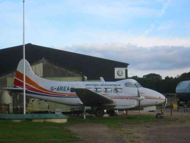
De Havilland Aircraft Museum
Museum · 2.7 mi
Aviation museum in Hertfordshire, United Kingdom

Hatfield House
Museum · 1.9 mi
Country house in Hatfield, Hertfordshire, England, UK

Hatfield War Memorial
Monument and historic site · 2.1 mi
War memorial in Hertfordshire, England, UK

The Troopie
Monument and historic site · 2.6 mi
Rhodesian statue in England

The War Memorial, St John's Churchyard
Monument and historic site · 3.3 mi
War memorial in Hertsmere, Hertfordshire, England, UK

Mill Green Museum and Working Mill
Museum · 2.7 mi
Local museum in Hatfield, Hertfordshire, England, United Kingdom

Parks, trails and playgrounds15


Oxleys Wood
Park · 1.1 mi
Nature reserve in Hatfield, Hertfordshire, England, UK

Stanborough Park
Park · 3.4 mi
Park in Welwyn Garden City, Hertfordshire, England

Furzefield Wood and Lower Halfpenny
Park · 2.1 mi
Nature reserve in Hertfordshire, England


3 more on the map.
Restaurants and cafes33



The Sibthorpe Arms
Bar and pub
Station Road, Hatfield
Mo-Th 12:00-22:00; Fr,Sa 12:00-23:00; Su 12:00-21:00
Elehouse
Bar and pub · 1.4 mi
College Lane, Hatfield
Mo-Fr 12:00+, Sa-Su 14:00+; PH off


21 more on the map.
Where to stay2


Notable people from Welham Green
- Steve ArnoldEnglish association football player (born 1989)
Born in Welham Green, according to Wikidata (CC0). Each name links to its Wikipedia article.
Churches and places of worship9
Kingdom Hall of Jehovah's Witnesses
Church · Jehovahs Witness · 0.8 mi
2-4 Hollyfield, Hatfield
Shopping2
Gas and EV charging3
Schools, colleges and libraries9
Royal Veterinary College, Potters Bar Campus
School · 1.5 mi
Hawkshead Lane, Hatfield
Healthcare4
Map of Welham Green
89 places. The map loads OpenStreetMap tiles when you open it.
Getting there and nearby towns
London Luton Airport (LTN) is the nearest airport with scheduled flights listed in OpenStreetMap, 12 miles away.
- Hatfield 2 mi north, about 3 min by car
- Potters Bar 3 mi southeast, about 5 min by car
- Welwyn Garden City 5 mi north, about 8 min by car
- St Albans 5 mi west, about 8 min by car
- Hadley Wood 5 mi southeast, about 8 min by car
- Park Street 5 mi west, about 8 min by car
- Sandridge 5 mi northwest, about 8 min by car
- Frogmore 5 mi west, about 8 min by car
- Barnet 6 mi south, about 10 min by car
- Borehamwood 6 mi southwest, about 10 min by car
Drive times are estimates from straight-line distance, not routes.
Towns near Welham Green


Keep exploring
Local news
Headlines from INDB.
Reviews, tips and questions
Loading what members have shared...
Sources and licences
- GeoNames (CC BY 4.0): population, coordinates, regions and time zone
- Mapillary (see each image): photos
- OpenStreetMap contributors (ODbL 1.0): places, airports, map data
- Wikidata (CC0 1.0): elevation, founding date, time zone, website, landmarks and historic places
- Wikimedia Commons (see each image): photos
- Wikipedia (CC BY-SA 4.0): overview and history text
Photo credits
- Balloon Corner Stone ,Welham Green .The first flight from English soil - 15th September 1784 (13992486447), PSParrot, CC BY 2.0
- Welham Green Station, Nigel Cox, CC BY-SA 2.0
- De Havilland Aircraft Museum Hertfordshire, Jack Hill, CC BY-SA 2.0
- Hatfield House, Allan Engelhardt, CC BY-SA 2.0
- Hatfield War Memorial, AnemoneProjectors, CC BY-SA 4.0
- Potters Bar war memorial, St John's Churchyard 10, Philafrenzy, CC BY-SA 4.0
- Oxleys Wood 5, Dudley Miles, CC BY-SA 4.0
- Stanborough park 01, Legis at English Wikipedia, Public domain
- Hatfield St Etheldreda, Cmglee, CC BY-SA 3.0
- UHCollegeLaneCampus, en:User:Jknabe and de:User:Jknabe, Public domain
- Church of St John the Evangelist, Hatfield, James Carrington, CC BY-SA 4.0
- Cock of the North Brookmans Park, RobThinks, CC BY-SA 4.0
- Colney Heath Local Nature Reserve 7, Dudley Miles, CC BY-SA 4.0
- Gobions Wood 7, Dudley Miles, CC BY-SA 4.0
- RLI Trooper Statue at Hatfield, April 2014, 1 (cropped), Cliftonian, CC BY-SA 3.0
- Marker-PICT2724, Rismyth, CC BY-SA 4.0
- GOC Brookmans Park 075 Brookmans (26714291392), Peter O'Connor aka anemoneprojectors, CC BY-SA 2.0
- Street-level photo, zymurgic, CC BY-SA 4.0
- Street-level photo, zymurgic, CC BY-SA 4.0
- Street-level photo, tonys999, CC BY-SA 4.0
- Street-level photo, tonys999, CC BY-SA 4.0
- Street-level photo, tompagenet, CC BY-SA 4.0
- Street-level photo, tonys999, CC BY-SA 4.0


Page built November 10, 2026. Spotted a mistake? Tell us or suggest a place.