


Ban Pong, Thailand
เทศบาลเมืองบ้านโป่ง
Ban Pong is a town of 57,559 people in Ratchaburi, Thailand.
Why visit Ban Pong
Townapedia lists 3 parks and trails, 3 places to eat and 1 place to stay in and around town.
Weather in Ban Pong
Forecast from MET Norway (CC BY 4.0). Full forecast
About Ban Pong
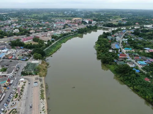
Ban Pong, (Thai: บ้านโป่ง), is a market town along the Mae Klong River in Thailand's Ratchaburi Province. Roughly 80 km (50 mi) west of Bangkok, it is the central town of the sub-provincial Ban Pong district, where its boundary aligned with that of the Ban Pong subdistrict (tambon).
From the Wikipedia article Ban Pong, Ratchaburi (this version), under CC BY-SA 4.0.
Photos of Ban Pong


Parks, trails and playgrounds3

Restaurants and cafes3

Riverside Bistro
Restaurant · Thai, Chinese, Craftbeer, Local Craft Beer · 2.1 km
19/50 sangchuto.rd
Mo-Su 11:00-00:00
ก๋วยเตี๋ยวเซียนปลา
Restaurant · Noodle · 1.9 km
417 ถนนแสงชูโต
09:30-16:00
ยำว่ะ Banpong
Restaurant · Thai, ยำแซลม่อน · 1.6 km
47/1
11.30 - 21.00
Where to stay1

Churches and places of worship4



History
The town was first officially registered as a sanitary district in 1916, after it was moved down the Mae Klong River from the old town, which is now part of Tha Pha municipality. The new town, when it was first built, was flooded with Chinese immigrants migrating from southern China where drought had occurred for four consecutive years in the 1920s. During the Second World War, the town experienced an economic boom due to its location being a hub between Bangkok to the east, Kanchanaburi to the north, and all the provinces in the south of Thailand. All goods transported by rail from Bangkok, Kanchanaburi, Burma and the southern provinces had to make a stop in Ban Pong.
In 1935, the sanitary district was upgraded to town status (thesaban mueang).
During the Second World War, the town was used by Japanese Forces as a base in the region while they were connecting the railway between Burma and Thailand, with train services running between Ban Pong and Mawlamyine in Burma during and for a few years after the war. The transit Camp Nong Pladuk was located about five kilometres from the railway station.
In the 1960s, the town again experienced an economic boom when several sugar refineries opened up in the area. Many large banking and governmental institutions sited their regional branches in Ban Pong.
From the History section of Ban Pong, Ratchaburi on Wikipedia, under CC BY-SA 4.0.
More about Ban Pong
Economy
In the district there are more than 400 factories, producing everything from jewellery to car parts to noodles. Hence, the town centre remains vibrant and prosperous. In recent years shopping at the town centre has experienced a decline in its importance owing to the opening of large shopping malls on the town's outskirts.
From the Wikipedia article Ban Pong, Ratchaburi, under CC BY-SA 4.0.
Gas and EV charging2
Schools, colleges and libraries5
Healthcare3
Map of Ban Pong
21 places. The map loads OpenStreetMap tiles when you open it.
Getting there and nearby towns
Kamphaeng Saen Airport (KDT) is the nearest airport with scheduled flights listed in OpenStreetMap, 32 km away.
- Nakhon Pathom 18 km east, about 18 min by car
- Ratchaburi 32 km south, about 32 min by car
- Kanchanaburi 41 km northwest, about 41 min by car
- Nong Khaem 52 km east, about 52 min by car
- Bang Bon 59 km east, about 59 min by car
- Bang Khae 59 km east, about 59 min by car
- Phasi Charoen 61 km east, about 1 h by car
- Bang Khun Thian 63 km east, about 1 h by car
- Taling Chan 63 km east, about 1 h by car
- Bangkok 68 km east, about 1 h 15 min by car
Drive times are estimates from straight-line distance, not routes.
Towns near Ban Pong


Keep exploring
Local news
Headlines from INDB.
Reviews, tips and questions
Loading what members have shared...
Sources and licences
- GeoNames (CC BY 4.0): population, coordinates, regions and time zone
- Mapillary (see each image): photos
- OpenStreetMap contributors (ODbL 1.0): places, airports, map data
- Wikidata (CC0 1.0): elevation, founding date, time zone, website
- Wikimedia Commons (see each image): photos
- Wikipedia (CC BY-SA 4.0): overview and history text
Photo credits
- ตำบล บ้านโป่ง จังหวัด ราชบุรี 70110 ประเทศไทย - panoramio, Phong Phat G, CC BY-SA 3.0
- วัดบ้านโป่ง (Wat Ban Pong) 2023, ยุทธนาสาระขันธ์, CC BY-SA 4.0
- Ban Pong Railway Station 20240113 01, Suikotei, CC BY 4.0
- Ban Pong Railway Station 20240113 07, Suikotei, CC BY 4.0
- Ban Pong Railway Station 20240113 02, Suikotei, CC BY 4.0
- Ban Pong Railway Station 20240113 04, Suikotei, CC BY 4.0
- Ban Pong Railway Station 20240113 05, Suikotei, CC BY 4.0
- Ban Pong Railway Station 20240113 06, Suikotei, CC BY 4.0
- 202402 Southern Line and Burma Railway Branch off in Ban Pong, MNXANL, CC BY-SA 4.0
- Ban Pong railway station (January 2025) - img 02, Reversemos.sapanaht, CC BY-SA 4.0
- New Ban Pong Railway Station 2025, Reversemos.sapanaht, CC BY-SA 4.0
- Ban Pong railway station (January 2025) - img 03, Reversemos.sapanaht, CC BY-SA 4.0
- Ban Pong railway station (January 2025) - img 10, Reversemos.sapanaht, CC BY-SA 4.0
- Ban Pong railway station (January 2025) - img 05, Reversemos.sapanaht, CC BY-SA 4.0
- Ban Pong railway station (January 2025) - img 07, Reversemos.sapanaht, CC BY-SA 4.0
- Ban Pong railway station (January 2025) - img 06, Reversemos.sapanaht, CC BY-SA 4.0
- Ban Pong railway station (January 2025) - img 09, Reversemos.sapanaht, CC BY-SA 4.0
- Ban Pong railway station (January 2025) - img 08, Reversemos.sapanaht, CC BY-SA 4.0
- Ban Pong railway station (January 2025) - img 01, Reversemos.sapanaht, CC BY-SA 4.0
- Ban Pong railway station (January 2025) - img 04, Reversemos.sapanaht, CC BY-SA 4.0
- Ban Pong railway station (January 2025) - img 11, Reversemos.sapanaht, CC BY-SA 4.0
- Bangping hospital20260627, ยุทธนาสาระขันธ์, CC BY-SA 4.0
- 202402 Station Building of Thanon Song Phon, MNXANL, CC BY-SA 4.0
- DJI 20241212144839 0068 D, Sittichai.okweaha, CC BY-SA 4.0
- ST Joseph Church Bangpong20260628, ยุทธนาสาระขันธ์, CC BY-SA 4.0
- Banpong Municipality2024, ยุทธนาสาระขันธ์, CC BY-SA 4.0
- วงเวียนช้าง - panoramio, mistercom, CC BY 3.0
- Street-level photo, Ting1967, CC BY-SA 4.0
- Street-level photo, mishari, CC BY-SA 4.0


Page built November 10, 2026. Spotted a mistake? Tell us or suggest a place.