


Bad Dürrheim, Germany
Bad Dürrheim is a town of 12,829 people in Baden-Wurttemberg, Germany.
Why visit Bad Dürrheim
Townapedia lists 61 museums and landmarks, 41 parks and trails, 213 places to eat, 45 places to stay and 24 attractions in and around town.
Highlights include Capitol VS, BlueBoxx, Fastnachtsmuseum Narrenschopf and Heimat- und Uhrenmuseum.
Weather in Bad Dürrheim
Forecast from MET Norway (CC BY 4.0). Full forecast
About Bad Dürrheim
Bad Dürrheim (German pronunciation: [baːt ˈdʏʁhaɪm] ; Low Alemannic: Diirä) is a town in the district of Schwarzwald-Baar, in Baden-Württemberg, Germany. It is situated east of the Black Forest, 8 km (5.0 mi) north of Donaueschingen, and 6 km (3.7 mi) southeast of Villingen.
From the Wikipedia article Bad Dürrheim (this version), under CC BY-SA 4.0.
Things to do24
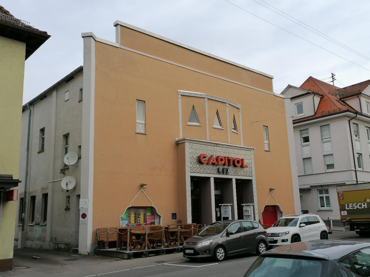
Capitol VS
Cinema and theater · 4.4 km
24 Alleenstraße, Villingen-Schwenningen
Tu-Th 18:00-01:00; Fr 18:00-03:00; Sa 15:00-03:00; Su 15:00-01:00

BlueBoxx
Cinema and theater · 6.4 km
11 Bertholdstraße, Villingen-Schwenningen
"täglich 30 Minuten vor Beginn der ersten Vorstellung"

Antoni-Hof Biolädele
Farm and orchard · 1.1 km
6 Aussiedlerhöfe, Bad Dürrheim
Tu 16:00-19:00; Fr 08:30-12:30,15:00-19:00

CineStar
Cinema and theater · 4.9 km
1 Schützenstraße, Villingen-Schwenningen
"15 Minuten vor dem ersten Film "

Wanne Observation Tower
Monument and historic site · 5.7 km
Observation tower in Villingen
Aussichtsturm Wanne
Scenic view · 5.7 km
30m Turm mit enger Wendeltreppe, offenes Stahlgerüst, 3 Plattformen, erbaut 1888. Leider inzw. hoher Wald, Aussicht teilw. zugewachsen

Hofladen Glatz
Farm and orchard · 5.4 km
Hofladen mit Gemüse, Eier, Milch
16 Oswald-Meder-Straße, Villingen-Schwenningen
24/7


Hofladen Link
Farm and orchard · 5.2 km
Eier, Nudeln, Kartoffeln, Wurst
24 Bachstraße, Tuningen
12 more on the map.
Museums and landmarks61

Fastnachtsmuseum Narrenschopf
Museum · 1.0 km
Mo off; Tu-Sa 14:00-17:00; Su 11:00-17:00; PH 11:00-17:00
Heimat- und Uhrenmuseum
Museum · 4.8 km
Kulturgeschichtliches Museum
16 Kronenstraße, Villingen-Schwenningen
Tu-Fr, Su 10:00-12:00, 14:00-18:00; Sa 14:00-18:00


Dorflinde
Monument and historic site · 4.9 km
Der älteste Lindenbaum im Schwarzwald-Baar-Kreis wurde um 1650 gepflanzt und am 11.12.1959 zum Naturdenkmal erklärt.
24/7


Magdalenenberg
Monument and historic site · 7.0 km
Iron Age tumulus in Germany

Museum Art.Plus
Museum · 8.1 km
Art museum in Donaueschingen, Germany

Uhrenindustriemuseum Schwenningen
Museum · 4.8 km
39 Bürkstraße, Villingen-Schwenningen
Mo off; Tu-Sa 13:00-17:00; Su 11:00-17:00
Dickenhardt Grabhügel
Monument and historic site · 3.2 km
Info-Tafel + 2 Bänkle. 2 Gräber ca. 600 v.Chr. im Museum.
24/7
49 more on the map.
Parks, trails and playgrounds41


Neckarbad
Sports field and stadium · 4.8 km
Außenbereich Neckarbad.
40 Lupfenstraße, Villingen-Schwenningen
Mo 13:00-21:00,Tu-Fr 06:30-21:00,Sa-Su 09:00-20:00
Eisstadion
Sports field and stadium · 3.4 km
7 Zum Mooswäldle, Villingen-Schwenningen
Dec 21-Mar 20 Mo 10:00-11:45,19:30-21:30; Dec 21-Mar 20 Tu-Fr...
Minara
Sports field and stadium · 0.6 km
18 Schabelweg, Bad Dürrheim
Oct-May: Tu 06:00-09:00, Tu 13:00-18:00, We 12:00-20:00, Th...




Spielplatz Schorenstraße (Melben)
Playground · 4.5 km
Mo-Su 08:00-13:00,15:00-20:00
29 more on the map.
Restaurants and cafes213

Hotel Salinensee
Restaurant · German, Regional · 0.7 km
1 Am Salinensee, Bad Dürrheim
Mo-We 17:00-20:30+; Sa 15:00-20:30+; Su 11:30-20:30
Royal Pizza Heimservice
Restaurant · Pizza · 5.4 km
Selbstabholer erhalten 15% Rabatt;außer Angebote.
1 Römerstraße, Villingen-Schwenningen
Tu-Sa 16:00-22:30; Su,PH 12:00-22:00
Am Pulvertürmle
Restaurant · Steak, Pasta, Salad · 6.5 km
Küche bis 21:30, an Feiertagen bis 21:00
Tu-Sa 11:30-14:00,17:30-23:00; Su 11:00-14:00
Bosporus
Restaurant · Turkish · 4.5 km
2 Alleenstraße, Villingen-Schwenningen
Mo-Fr 11:30-14:00,17:00-22:00;Sa 17:00-23:00;Su,PH 12:00-22:00

Cafe Bistro Vau
Cafe · Regional, Tuscan, Coffee Shop · 4.6 km
18 Friedrich-Ebert-Straße, Villingen-Schwenningen
Tu-Fr 09:30-14:30, Sa 09:30-24:00, Su 10:00-13:30
Cafe Hildebrand
Restaurant · German · 3.0 km
1/1 Zollhäusleweg, Villingen-Schwenningen
We-Su 11:00-22:00

Fürstenberg's Irish Pub Schwenningen
Bar and pub · Burger, Chicken · 4.8 km
24 Kronenstraße, Villingen-Schwenningen
Mo-Th 16:00-01:00; Fr,Sa 16:00-03:00; Su off


Gelateria Gianotti
Cafe · Ice Cream, Coffee Shop · 4.6 km
38 In der Muslen, Villingen-Schwenningen
Mo-Sa 09:00-19:00; Su,PH 10:00-19:00
201 more on the map.
Where to stay45
Churches and places of worship50
St. Franziskus
Church · Catholic · 4.6 km
9 Jakob-Kienzle-Straße, Villingen-Schwenningen
Jakobuskirche Marbach
Church · Catholic · 4.6 km
8 Kirchdorfer Straße, Villingen-Schwenningen
Johanneskirche
Church · Protestant · 4.3 km
42 Mozartstraße, Villingen-Schwenningen
Pauluskirche
Church · Protestant · 4.2 km
10 Paulusplatz, Villingen-Schwenningen
Shopping50
Gas and EV charging40
Schools, colleges and libraries34
Stadtbibliothek am Muslenplatz
Library · 4.8 km
2 In der Muslen, Villingen-Schwenningen
Villingen-Schwenningen University of Police
School · 5.1 km
250 Sturmbühlstraße, Villingen-Schwenningen
Bibliothek der DHBW VS
Library · 4.4 km
30 Friedrich-Ebert-Straße, Villingen-Schwenningen
Healthcare17
Apotheke in der Klinikstraße
Clinic and pharmacy · 5.2 km
3 Klinikstraße, Villingen-Schwenningen
Apotheke im Culinara
Clinic and pharmacy · 5.1 km
18 Spittelstraße, Villingen-Schwenningen
Map of Bad Dürrheim
250 places. The map loads OpenStreetMap tiles when you open it.
Getting there and nearby towns
Lahr Airport (LHA) is the nearest airport with scheduled flights listed in OpenStreetMap, 65 km away.
- Villingen-Schwenningen 5 km northwest, about 5 min by car
- Donaueschingen 8 km south, about 8 min by car
- Trossingen 10 km northeast, about 10 min by car
- Spaichingen 16 km east, about 16 min by car
- Rottweil 18 km northeast, about 18 min by car
- St. Georgen im Schwarzwald 19 km northwest, about 19 min by car
- Blumberg 20 km south, about 20 min by car
- Tuttlingen 22 km east, about 22 min by car
- Schramberg 25 km northwest, about 25 min by car
- Titisee-Neustadt 28 km southwest, about 28 min by car
Drive times are estimates from straight-line distance, not routes.
Local news
Headlines from INDB.
Reviews, tips and questions
Loading what members have shared...
Sources and licences
- GeoNames (CC BY 4.0): population, coordinates, regions and time zone
- Mapillary (see each image): photos
- OpenStreetMap contributors (ODbL 1.0): places, airports, map data
- Wikidata (CC0 1.0): elevation, founding date, time zone, website, landmarks and historic places
- Wikimedia Commons (see each image): photos
- Wikipedia (CC BY-SA 4.0): overview and history text
Photo credits
- BadDuerrheimKurpark, Ramessos, Public domain
- Bad Dürrheim Johanneskirche, Hooosdoy, CC BY-SA 4.0
- Bad Dürrheim Rebholz3, Hooosdoy, CC BY-SA 4.0
- Bad Dürrheim Rebholz2, Hooosdoy, CC BY-SA 4.0
- Bad Dürrheim Rebholz, Hooosdoy, CC BY-SA 4.0
- Bad Dürrheim Salinenapotheke, Hooosdoy, CC0
- Bad Dürrheim Carat, Hooosdoy, CC0
- Bad Dürrheim Restaurants Sao Mai, Hooosdoy, CC0
- Bad Dürrheim Shop zahn und kunst, Hooosdoy, CC BY-SA 4.0
- Bad Dürrheim Shop Tattoo Nika Tuk, Hooosdoy, CC BY-SA 4.0
- Bad Dürrheim shop tbu, Hooosdoy, CC BY-SA 4.0
- Bad Dürrheim shop Volksbank, Hooosdoy, CC BY-SA 4.0
- Bad Dürrheim Shop Pflegeservice, Hooosdoy, CC BY-SA 4.0
- Bad Dürrheim Shop Modelia, Hooosdoy, CC BY-SA 4.0
- Bad Dürrheim Shop NKD, Hooosdoy, CC BY-SA 4.0
- Bad Dürrheim shop Betreuung und Pflege Zuhause Curanum, Hooosdoy, CC BY-SA 4.0
- Bad Dürrheim Shop CAP, Hooosdoy, CC BY-SA 4.0
- Bad Dürrheim Shop Krachenfels 1, Hooosdoy, CC BY-SA 4.0
- Bad Dürrheim Shop Kosmetik Heike, Hooosdoy, CC BY-SA 4.0
- Bad Dürrheim Reichmann, Hooosdoy, CC BY-SA 4.0
- Bad Dürrheim Polizei, Hooosdoy, CC BY-SA 4.0
- Bad Dürrheim Thomas Winter Holzbildhauer Atelier, Hooosdoy, CC BY-SA 4.0
- Bad Dürrheim Biovida, Hooosdoy, CC BY-SA 4.0
- Bad Dürrheim SBVV, Hooosdoy, CC BY-SA 4.0
- Bad Dürrheim Waschsalon, Hooosdoy, CC BY-SA 4.0
- Bad Dürrheim Morys Hofbuchhandlung, Hooosdoy, CC BY-SA 4.0
- Bad Dürrheim Shop Annette's Haar-mobil, Hooosdoy, CC BY-SA 4.0
- Bad Dürrheim Shop Bio-Kosmetik med.Fußpflege, Hooosdoy, CC BY-SA 4.0
- Bad Dürrheim Cafe FLAIR, Hooosdoy, CC BY-SA 4.0
- Bad Dürrheim Shop Diakonie, Hooosdoy, CC BY-SA 4.0
- Bad Dürrheim Shop PIZZA EXPRESS MAMMA MIA, Hooosdoy, CC BY-SA 4.0
- Bad Dürrheim shop Schnipp-Schnapp, Hooosdoy, CC0
- Bad Dürrheim Briefkasten, Hooosdoy, CC BY-SA 4.0
- Bad Dürrheim shop Steuerring, Hooosdoy, CC0
- Bad Dürrheim Konditorei Röder, Hooosdoy, CC BY-SA 4.0
- Bad Dürrheim Schwarzwald-Pavillon, Hooosdoy, CC BY-SA 4.0
- Bad Dürrheim Hegibrunnen, Hooosdoy, CC0
- Bad Dürrheim shop Volksbank & Sparkasse, Hooosdoy, CC0
- Bad Dürrheim shop Deutsche Vermögensberatung, Hooosdoy, CC0
- Bad Dürrheim Restaurant Schwarzwälder Hof, Hooosdoy, CC0
- Museum Biedermann, Museum Art.Plus, CC BY-SA 3.0
- Aussichtsturm Wanne, Villinger10 at English Wikipedia, CC BY-SA 3.0
- Ruine Warenburg (VS)-5208, DKrieger, CC BY-SA 4.0
- BW Bad Duerrheim 3, PaulT (Gunther Tschuch), CC BY-SA 4.0
- D-VS-Gartenschule, Okmijnuhb, CC BY 3.0
- D-VS-GaD-Suedseite, Okmijnuhb, CC BY 3.0
- Neckar-Ursprung im Schwenninger Moos, Harke, CC BY-SA 3.0
- FTS Alt und Werkstattbau, No machine-readable author provided. Marc28 assumed (based on copyright claims)., CC BY-SA 3.0
- Internationales Luftfahrt-Museum hangar, Nimbus227, CC BY-SA 4.0
- Landappbw 385505 1819 Capitol Capitol Schwenningen, Harry Schneckenburger, CC0
- Villingen BlueBoxx, Photo: Andreas Praefcke, CC BY 3.0
- Katholische Kirche St. Franziskus in Schwenningen - panoramio, qwesy qwesy, CC BY 3.0
- Mühlhauser Halde-9579 HDR, DKrieger, CC BY-SA 4.0
- GaH Front, Aletz, CC BY-SA 4.0
- Heidenhofen, Kirche St. Hilarius, Rauenstein, CC BY-SA 3.0
- Tuningen-8452, DKrieger, CC BY-SA 4.0
- Pauluskirche Schwenningen-5761, DKrieger, CC BY-SA 4.0
- Marbach, Kirche St. Jakobus, Rauenstein, CC BY-SA 3.0
- Landappbw 315893 1820 Kirche Rietheim, Harry Schneckenburger, CC0
- Mühlhausen bei Schwenningen-2862, DKrieger, CC BY-SA 4.0
- Antoni-Hof Biolädle, H3wastooshort, CC BY-SA 4.0
- Naturdenkmal vor der Kirche von Heidenhofen, EinEngener, CC BY-SA 4.0
- Landappbw 310957 1820 Stadtkirche Schwenningen 960x960, Harry Schneckenburger, CC0
- Türnleberg-7441, DKrieger, CC BY-SA 4.0
- Helios Arena - panoramio, qwesy qwesy, CC BY 3.0
- Street-level photo, changchun1, CC BY-SA 4.0
- Street-level photo, tobim91, CC BY-SA 4.0
- Street-level photo, tobim91, CC BY-SA 4.0
- Street-level photo, tasmaniadevil, CC BY-SA 4.0
- Street-level photo, tobim91, CC BY-SA 4.0
- Street-level photo, tobim91, CC BY-SA 4.0
- Street-level photo, changchun1, CC BY-SA 4.0
- Street-level photo, tobim91, CC BY-SA 4.0
- Street-level photo, changchun1, CC BY-SA 4.0
- Street-level photo, ramap, CC BY-SA 4.0
- Street-level photo, tobim91, CC BY-SA 4.0
- Street-level photo, ramap, CC BY-SA 4.0
- Street-level photo, ramap, CC BY-SA 4.0
- Street-level photo, mfa, CC BY-SA 4.0
- Street-level photo, ramap, CC BY-SA 4.0
- Street-level photo, tobim91, CC BY-SA 4.0


Page built November 8, 2026. Spotted a mistake? Tell us or suggest a place.