



Why visit Airth
Townapedia lists 14 museums and landmarks, 1 park or trail, 4 places to eat, 1 place to stay and 3 attractions in and around town.
Highlights include Clackmannanshire Bridge, Kincardine Bridge, Elphinstone Tower and Arthur's O'on temple.
Weather in Airth
Forecast from MET Norway (CC BY 4.0). Full forecast
About Airth
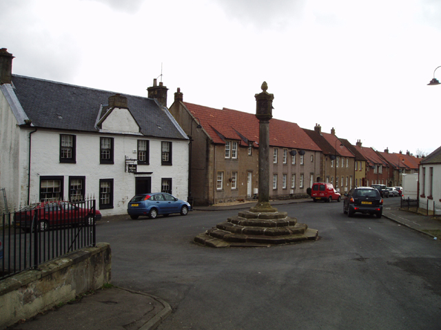
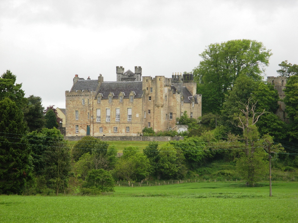
Airth (Scottish Gaelic: An Àird) is a Royal Burgh, village, former trading port and civil parish in Falkirk, Scotland. It is 6 miles (10 kilometres) north of Falkirk town and sits on the banks of the River Forth. Airth lies on the A905 road between Grangemouth and Stirling and is overlooked by Airth Castle; the village retains two market crosses and a small number of historic houses. At the time of the 2001 census the village had a population of 1,273 residents but this has been revised to 1,660 according to a 2008 estimate.
From the Wikipedia article Airth (this version), under CC BY-SA 4.0.
Photos of Airth

Things to do3

Clackmannanshire Bridge
Bridge · 1.4 mi
Bridge between Falkirk and Fife, Scotland, UK, carries the A876 road across River Forth

Kincardine Bridge
Bridge · 1.8 mi
Bridge between Falkirk and Fife, Scotland

Alloa Swing Bridge
Bridge · 3.2 mi
Demolished railway swing bridge in Scotland
Museums and landmarks14

Elphinstone Tower
Monument and historic site · 0.9 mi
Ruin of old tower with remains of mausoleum

Arthur's O'on temple
Monument and historic site · 3.3 mi
Probable Roman temple near Falkirk, Scotland, destroyed in 1743

The Dunmore Pineapple
Museum · 0.7 mi
Bizarre fruit-inspired building set within a woodland full of wildlife.




2 more on the map.
Parks, trails and playgrounds1

Restaurants and cafes4


History
The village has long association with the River Forth and it was on the banks of the river that a royal dockyard was created. In September 1506 Andrew Aytoun was paid for "casting of the dock in the Poll of Erth" for the ship. The dock was used during the years 1507–1513 in the reign of James IV to build ships of war at the pool of Airth. In 1511 and 1512 Robert Calendar made three docks, a stable for 50 horses, and a larger dock for the Margaret. Calendar's men also worked on the Lark and the James.
A form of dry dock may have been used. Strong timbers would be used to form the “stocks” for the vessel and a clay dam would prevent the river from penetrating the working area. When the ship was ready, the dam would be breached, at high tide, to enable it to float out into the river.
The shipping fleet was destroyed in 1745 by Bonnie Prince Charlie when some ship to shore skirmishes took place by batteries set by Jacobites to drive off the government ships. A number of smaller vessels from the village were burned by loyalist troops and that proved damaging to Airth's subsequent development as a port. However, as late as 1820 sloops built in the shipyards at Airth were among those recorded as operating in the middle of the Forth .
Dunmore Park and the Dunmore Pineapple is an historic estate in Airth, formerly the ancestral residence of the Earl of Dunmore.
Read more of the history
The name Airth comes from the Gaelic term Àird meaning a height or hill after the nearby Hill of Airth.
From the History section of Airth on Wikipedia, under CC BY-SA 4.0.
Notable people from Airth
 William Fullerton-ElphinstoneDirector of the East India CompanyPhoto: Print made by: Louis Haghe After:..., Public domain
- L. W. HinxmanBritish geologist (1855-1936)
Born in Airth, according to Wikidata (CC0). Each name links to its Wikipedia article.
Where to stay1
Churches and places of worship3
Gas and EV charging1
Schools, colleges and libraries1
Healthcare1
Map of Airth
29 places. The map loads OpenStreetMap tiles when you open it.
Getting there and nearby towns
Edinburgh Airport (EDI) is the nearest airport with scheduled flights listed in OpenStreetMap, 18 miles away.
- Alloa 3 mi north, about 5 min by car
- Grangemouth 4 mi southeast, about 7 min by car
- Falkirk 5 mi south, about 8 min by car
- Stirling 7 mi northwest, about 12 min by car
- Bo’ness 7 mi southeast, about 11 min by car
- Linlithgow 9 mi southeast, about 15 min by car
- Cumbernauld 12 mi southwest, about 19 min by car
- Dunfermline 12 mi east, about 19 min by car
- Bathgate 13 mi southeast, about 20 min by car
- Rosyth 13 mi east, about 21 min by car
Drive times are estimates from straight-line distance, not routes.
Towns near Airth


Keep exploring
Local news
Headlines from INDB.
Reviews, tips and questions
Loading what members have shared...
Sources and licences
- GeoNames (CC BY 4.0): population, coordinates, regions and time zone
- Mapillary (see each image): photos
- OpenStreetMap contributors (ODbL 1.0): places, airports, map data
- Wikidata (CC0 1.0): elevation, founding date, time zone, website, landmarks and historic places
- Wikimedia Commons (see each image): photos
- Wikipedia (CC BY-SA 4.0): overview and history text
Photo credits
- Airth Mercat Cross, Kevin Rae, CC BY-SA 2.0
- Upper Forth Crossing, Paul McIlroy, CC BY-SA 2.0
- Kincardine Bridge, Ian Mitchell, CC BY-SA 2.0
- Arthur's oven - Gordon 1726, Unknown author Unknown author, Public domain
- Airth Castle, Supergolden, CC BY-SA 3.0
- St. Mungo's Parish Church, Alloa (1), DreComm, CC BY-SA 3.0
- Elphinstone tower 190609 - 01, Bubobubo2, CC BY-SA 3.0
- Scotland-2016-Aerial-Stirlingshire-Dunmore House, Godot13, CC BY-SA 4.0
- Dunmore pineapple, giannandrea, CC0
- Elphinstone Tower (25565323455), Neil Williamson from Dundee, Scotland, CC BY-SA 2.0
- Dunmore Park Stables (3980513476), Tom Parnell from Scottish Borders, Scotland, CC BY-SA 2.0
- Airth castle - panoramio, Tobias Barkskog, CC BY 3.0
- Street-level photo, ccbb7766, CC BY-SA 4.0
- Street-level photo, neilbenny, CC BY-SA 4.0
- Street-level photo, ccbb7766, CC BY-SA 4.0
- Street-level photo, ccbb7766, CC BY-SA 4.0
- Street-level photo, ccbb7766, CC BY-SA 4.0
- Street-level photo, ccbb7766, CC BY-SA 4.0
- Street-level photo, neilbenny, CC BY-SA 4.0
Page built November 10, 2026. Spotted a mistake? Tell us or suggest a place.