
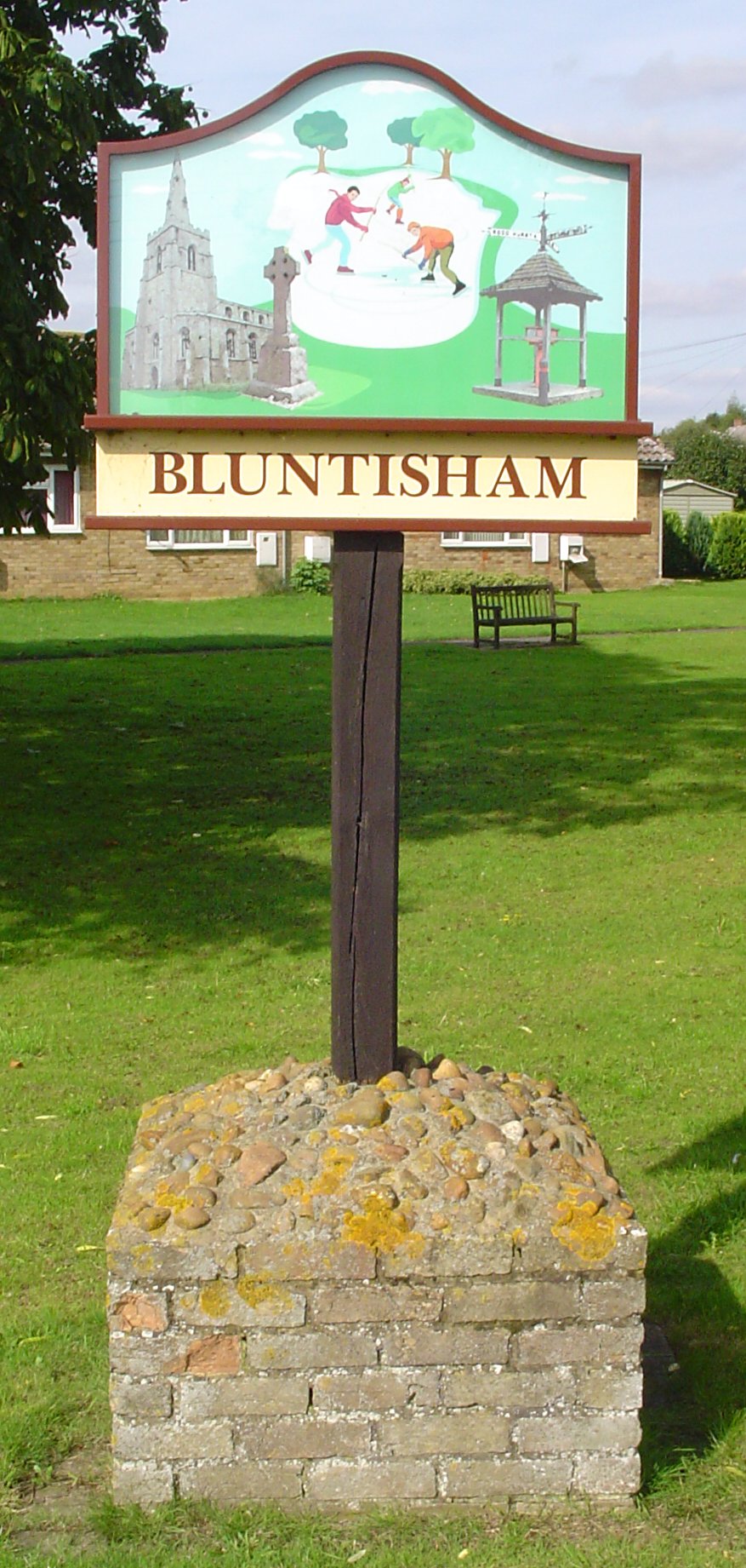

Bluntisham, United Kingdom
Bluntisham is a town of 2,868 people in England, United Kingdom.
Why visit Bluntisham
Townapedia lists 6 museums and landmarks, 5 parks and trails, 7 places to eat, 3 places to stay and 2 attractions in and around town.
Highlights include War Memorial, Swavesey Priory, Mare Fen and Somersham Local Nature Reserve.
Weather in Bluntisham
Forecast from MET Norway (CC BY 4.0). Full forecast
About Bluntisham
Bluntisham is a village and civil parish in Cambridgeshire, England. The population of the civil parish at the 2011 census was 2,003. Bluntisham lies approximately 8 miles (13 km) east of Huntingdon. Bluntisham is situated within Huntingdonshire which is a non-metropolitan district of Cambridgeshire as well as being a historic county of England.
From the Wikipedia article Bluntisham (this version), under CC BY-SA 4.0.
Things to do2

Museums and landmarks6

Swavesey Priory
Monument and historic site · 3.4 mi
Priory in Swavesey, South Cambridgeshire, England, UK
Parks, trails and playgrounds5

Somersham Local Nature Reserve
Park · 2.0 mi
Local Nature Reserve in Cambridgeshire, England

Restaurants and cafes7
The White Swan
Bar and pub
30 High Street, Huntingdon
Mo-Th 16:00-22:00; Fr-Su 12:00-23:00
The Lounge
Cafe · 0.4 mi
Station Road, Huntingdon
Tu-Sa 08:00-15:00; Su 09:00-14:00

History
There is evidence to suggest that Neolithic and Roman inhabitants once settled in Bluntisham. The manor of Bluntisham goes back to the early part of the 10th century, when it was seized by Toli the Dane, who is said to have been the jarl or alderman of Huntingdon. Toli was killed at the Battle of Tempsford in 917, at which point the county returned to the rule of Edward the Elder. Bluntisham later became the property of Wulfnoth Cild who sold it circa 970–75 to Bishop Æthelwold of Winchester and Brithnoth, the first Abbot of Ely, for the endowment of Ely Abbey. The sale was confirmed by King Edgar, but when he died in 975 a claim was made by the sons of Bogo de Hemingford, who believed that it was the inheritance of their uncle. Their claim was declared false at the county court, and the sale to Ely Abbey went ahead.
Bluntisham was listed as Bluntesham in the Domesday Book of 1086 in the Hundred of Hurstingstone in Huntingdonshire. There were two manors and 16 households at Bluntisham, giving an approximate population of 56 to 80 people. The survey records that there was 6 ploughlands with the capacity for a further 2.62. In addition to the arable land, there was 20 acres (8 hectares) of meadows and 194 acres (79 hectares) of woodland. For the manors at Bluntisham the total tax assessed was seven geld. There was already a church and a priest at Bluntisham.
Read more of the history
Bluntisham remained under ownership of the Bishop of Ely until the dissolution of the monasteries, when it was granted to the dean and chapter of Ely. Valentine Walton was appointed governor of Ely in 1649 for his services to Oliver Cromwell's Parliament. Upon the Restoration, it was restored to the dean and chapter. In 1869, it was taken over by the Ecclesiastical Commissioners, who remain lords of the manor.
The village was built up around four fields. The north-western part of the parish contains Higham Field, with Gull Field (named for the gills which slope towards the Great Ouse) to the south-west. Colneway Field lay to the north-east of Higham Field, with Old Mill (or "Inhams") Field located between Colneway and Bury Fen, stretching to Earith. A large wood known as "Bluntisham Hangar" once existed south of Highams Field, and is probably that mentioned in the Domesday Book. In 1341 the wood was recorded as the boundary of the Bishop of Ely's right of hunting. Bluntisham's woodland declined from 68 acres (28 ha) in 1843 to 10 acres (4.0 ha) by 1925.
From the History section of Bluntisham on Wikipedia, under CC BY-SA 4.0.
More about Bluntisham
Geography
The area is low-lying and very flat. The gravel soil is used to grow fruit trees, barley and oats, while wheat is grown in the loam and clay soil. The village was once home to many orchards, and fruit farming was very profitable. Some residents still sell fruit on roadside stalls, but oilseed rape is the more popular crop nowadays. Traditionally water was derived from gravel springs, but later wells were fed by surface water. A hand water pump, now defunct, still stands on the high street. Somersham Road yielded a chalybeate spring, where more than one attempt was made in the 18th century to establish a spa. The "healing" properties of its waters were recommended by John Addenbrooke (d.1719), founder of Addenbrooke's Hospital in Cambridge, among others.
Arts and culture
The parish was once home to the most successful Bandy club in British history, the Bury Fen Bandy club. From this famous club came Charles Goodman Tebbutt, who was responsible for the first published rules of Bandy in 1882. Bury Fen is still popular for ice skating when it floods and freezes over in colder winters.
The author and agricultural reformist H. Rider Haggard visited the village in 1901, while travelling through Huntingdonshire. He commented on the "very excellent dwellings", built for local agricultural workers.
The Barograph in the centre of the High Street was erected in 1911 as a memorial to some of the Tebbutt family and is kept in working order by the Bluntisham Feoffees charity.
Education
Bluntisham has its own primary school, St Helen's, which educates children aged 4–11. The school is linked to the secondary school Abbey College, in Ramsey.
From the Wikipedia article Bluntisham, under CC BY-SA 4.0.
Notable people from Bluntisham
- Jervoise Athelstane BainesBritish colonial administrator (1847–1925)
- Robert SeeleyPuritan settler in the Massachusetts Bay Colony
- Peter GodfreyBritish-New Zealand conductor
Born in Bluntisham, according to Wikidata (CC0). Each name links to its Wikipedia article.
Where to stay3
Churches and places of worship3
Shopping1
Gas and EV charging1
Schools, colleges and libraries2
Map of Bluntisham
30 places. The map loads OpenStreetMap tiles when you open it.
Getting there and nearby towns
Cambridge City Airport (CBG) is the nearest airport with scheduled flights listed in OpenStreetMap, 12 miles away.
- Earith 1 mi east, about 1 min by car
- Somersham 2 mi north, about 3 min by car
- Needingworth 2 mi southwest, about 4 min by car
- Over 3 mi south, about 4 min by car
- Saint Ives 4 mi southwest, about 6 min by car
- Swavesey 4 mi south, about 6 min by car
- Fenstanton 5 mi southwest, about 8 min by car
- Hemingford Grey 5 mi southwest, about 8 min by car
- Longstanton 5 mi south, about 9 min by car
- Haddenham 6 mi east, about 9 min by car
Drive times are estimates from straight-line distance, not routes.
Towns near Bluntisham


Keep exploring
Local news
Headlines from INDB.
Reviews, tips and questions
Loading what members have shared...
Sources and licences
- GeoNames (CC BY 4.0): population, coordinates, regions and time zone
- Mapillary (see each image): photos
- OpenStreetMap contributors (ODbL 1.0): places, airports, map data
- Wikidata (CC0 1.0): elevation, founding date, time zone, website, landmarks and historic places
- Wikimedia Commons (see each image): photos
- Wikipedia (CC BY-SA 4.0): overview and history text
Photo credits
- UK Bluntisham, Uksignpix, CC BY-SA 3.0
- Somersham Local Nature Reserve 2, Dudley Miles, CC BY-SA 4.0
- Street-level photo, adam2, CC BY-SA 4.0
- Street-level photo, adam2, CC BY-SA 4.0
- Street-level photo, adam2, CC BY-SA 4.0
- Street-level photo, adam2, CC BY-SA 4.0
- Street-level photo, adam2, CC BY-SA 4.0
- Street-level photo, adam2, CC BY-SA 4.0
- Street-level photo, adam2, CC BY-SA 4.0
- Street-level photo, adam2, CC BY-SA 4.0
- Street-level photo, adam2, CC BY-SA 4.0
- Street-level photo, adam2, CC BY-SA 4.0
- Street-level photo, adam2, CC BY-SA 4.0
- Street-level photo, adam2, CC BY-SA 4.0
- Street-level photo, adam2, CC BY-SA 4.0
- Street-level photo, adam2, CC BY-SA 4.0
Page built November 10, 2026. Spotted a mistake? Tell us or suggest a place.