


Why visit Brompton
Townapedia lists 11 museums and landmarks, 12 parks and trails, 79 places to eat, 9 places to stay and 4 attractions in and around town.
Highlights include North Northallerton bridge, The Hambleton Forum, Romanby War Memorial Clock Tower and Battle of the Standard.
Weather in Brompton
Forecast from MET Norway (CC BY 4.0). Full forecast
About Brompton
Brompton is a village and civil parish in the unitary area and county of North Yorkshire, England, about 1.6 miles (2.6 km) north of Northallerton. The village was near the site of a battle between English and Scots armies and was the location of mills producing linen goods from the 18th century onward.
From the Wikipedia article Brompton, Northallerton (this version), under CC BY-SA 4.0.
Photos of Brompton

Things to do4

North Northallerton bridge
Bridge · 0.8 mi
Road bridge in North Yorkshire, England



Museums and landmarks11
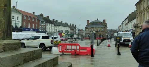
Romanby War Memorial Clock Tower
Monument and historic site · 2.1 mi
War memorial clock tower in Romanby, North Yorkshire, England, UK



Parks, trails and playgrounds12



Restaurants and cafes79


Caffè Nero
Cafe · Coffee Shop · 1.4 mi
93 High Street, Northallerton
Mo-Fr 07:00-18:00; Sa 07:30-18:00; Su 07:30-17:30

67 more on the map.
History
Brompton is mentioned in the Domesday Book of 1086 as Bruntone in the Allerton hundred. Before the invasion, the manor was granted to Earl Edwin, but was granted to the Crown in 1086 and was added to the lands that were the possession of the Bishop of Durham, St Cuthbert, and remained so after 1086. In 1836 the land was transferred to the see of Ripon. The village became an ecclesiastical parish in 1843.
The etymology of the name Brompton is derived from a combination of the Old English word brōm, meaning broom and the Old English suffix of tūn, meaning farm or settlement. Put together they mean broom farm.
The traditional location for the site of the Battle of the Standard in 1138 is just north-west of Brompton, on land bounded by the A167 road to the west, an overgrown track known as Scotpit Lane to the south and Brompton Lane to the east that is called Standard Hill. This site was where the local militia gathered before the campaign to retake Scotland by Edward I in 1303.
Read more of the history
Brompton was an important centre for linen making and weaving in the 19th century with eight mills at its peak in 1820 but the industry had declined by the early 20th century. The John Pattison Yeomans Mill was located in what is now the residential area of Linen Way. Bricks from the demolished chimney of the John Wilford Mill on Station road now form a memorial to linen workers on Water End Green, opposite the Village Inn. Brompton is now largely residential with just a few small businesses, Wilford Mill remains and is occupied by small businesses but its iconic chimney has been demolished.
Brompton has one of the earliest online interactive war memorials where it is possible to find information and photographs of the soldiers to have died in the First World War and the Second World War from the area.
The Willow Beck was the water source for the linen mills and created regular floods, mainly at the Water End area of the village. Since the factory's demolition flooding is no longer commonplace and the last time any properties suffered flood damage was 2000. Extensive flood defence work has been carried out, mainly to protect the school and Station Road area by building flood banks. Engineering work has also been carried out on various parts of the river such as the removal and widening of bends in the banks and creating a bypass when the water reaches its peak.
From the History section of Brompton, Northallerton on Wikipedia, under CC BY-SA 4.0.
More about Brompton
Geography
Brompton lies between the A167 Northallerton to Darlington road and the A684 Northallerton to Stokesley road. It had a railway station on the line between Northallerton and Middlesbrough that passes around its northern boundary. The Brompton or Willow Beck that flows through the village is part of the tributary system of the River Wiske.
Education
Brompton Community Primary School has a capacity of around 210 children of mixed gender between the ages of 3 and 11. Pupils at this school are within the catchment area of Northallerton School & Sixth Form College for secondary education.
From the Wikipedia article Brompton, Northallerton, under CC BY-SA 4.0.
Notable people from Brompton
- Arthur RobinsonEnglish cricketer for Yorkshire (born 1946)
Born in Brompton, according to Wikidata (CC0). Each name links to its Wikipedia article.
Where to stay9
Churches and places of worship30
All Saints Church
Church · Anglican · 1.3 mi
High Street, Northallerton
Shopping23
Gas and EV charging3
Schools, colleges and libraries12
Sacred Heart Catholic Primary School
School · Roman Catholic · 2.1 mi
Broomfield Avenue, Northallerton
Healthcare3
Map of Brompton
186 places. The map loads OpenStreetMap tiles when you open it.
Getting there and nearby towns
Teesside International Airport (MME) is the nearest airport with scheduled flights listed in OpenStreetMap, 11 miles away.
- Northallerton 1 mi south, about 2 min by car
- Scorton 8 mi west, about 13 min by car
- Yarm 10 mi north, about 17 min by car
- Darlington 12 mi northwest, about 20 min by car
- Thornaby-on-Tees 13 mi northeast, about 21 min by car
- Masham 13 mi southwest, about 21 min by car
- Ingleby Greenhow 14 mi northeast, about 23 min by car
- Stockton-on-Tees 15 mi north, about 24 min by car
- Middlesbrough 17 mi northeast, about 27 min by car
- Billingham 17 mi north, about 27 min by car
Drive times are estimates from straight-line distance, not routes.
Towns near Brompton


Keep exploring
Local news
Headlines from INDB.
Reviews, tips and questions
Loading what members have shared...
Sources and licences
- GeoNames (CC BY 4.0): population, coordinates, regions and time zone
- Mapillary (see each image): photos
- OpenStreetMap contributors (ODbL 1.0): places, airports, map data
- Wikidata (CC0 1.0): elevation, founding date, time zone, website, landmarks and historic places
- Wikimedia Commons (see each image): photos
- Wikipedia (CC BY-SA 4.0): overview and history text
Photo credits
- Chapel House, Brompton, Gordon Hatton, CC BY-SA 2.0
- The Three Horseshoes, Brompton, Gordon Hatton, CC BY-SA 2.0
- All Saints Church, Deighton, Mick Garratt, CC BY-SA 2.0
- Ainderby-Steeple-Parish-Church, Kreuzschnabel, CC BY-SA 3.0
- All Saints, Chrisloader, Public domain
- Battle of the Standard (J. Gilbert), John Gilbert, Public domain
- United Reformed Church, Northallerton, The joy of all things, CC BY-SA 4.0
- Friarage Hospital, Chrisloader, CC BY-SA 3.0
- Northallerton Forum, Mick Garratt, CC BY-SA 2.0
- Northallerton Library, Chrisloader, CC BY-SA 3.0
- Nags Head, Northallerton, The joy of all things, CC BY-SA 4.0
- Golden Lion Hotel, Northallerton, The joy of all things, CC BY-SA 4.0
- Battle of the Standard monument, The joy of all things, CC BY 4.0
- North Northallerton Bridge, The joy of all things, CC BY-SA 4.0
- Golden Lion Hotel - panoramio, flipflopnick, CC BY-SA 3.0
- Market Cross - panoramio, flipflopnick, CC BY-SA 3.0
- Porch House (Plaque) - panoramio, flipflopnick, CC BY-SA 3.0
- Street-level photo, locator, CC BY-SA 4.0
- Street-level photo, chris_debian, CC BY-SA 4.0
- Street-level photo, chris_debian, CC BY-SA 4.0
- Street-level photo, chris_debian, CC BY-SA 4.0
- Street-level photo, parson983, CC BY-SA 4.0
- Street-level photo, jethro10, CC BY-SA 4.0
- Street-level photo, jethro10, CC BY-SA 4.0
- Street-level photo, locator, CC BY-SA 4.0
- Street-level photo, locator, CC BY-SA 4.0
- Street-level photo, locator, CC BY-SA 4.0
- Street-level photo, locator, CC BY-SA 4.0
- Street-level photo, jethro10, CC BY-SA 4.0
- Street-level photo, locator, CC BY-SA 4.0
- Street-level photo, parson983, CC BY-SA 4.0
- Street-level photo, parson983, CC BY-SA 4.0
- Street-level photo, locator, CC BY-SA 4.0
- Street-level photo, endszbrxns, CC BY-SA 4.0
- Street-level photo, locator, CC BY-SA 4.0
- Street-level photo, locator, CC BY-SA 4.0
- Street-level photo, locator, CC BY-SA 4.0
- Street-level photo, locator, CC BY-SA 4.0
- Street-level photo, locator, CC BY-SA 4.0
- Street-level photo, jethro10, CC BY-SA 4.0
- Street-level photo, locator, CC BY-SA 4.0
- Street-level photo, chris_debian, CC BY-SA 4.0
- Street-level photo, jethro10, CC BY-SA 4.0
- Street-level photo, locator, CC BY-SA 4.0


Page built November 10, 2026. Spotted a mistake? Tell us or suggest a place.