

Carryduff, United Kingdom
Carryduff is a town of 7,798 people in Northern Ireland, United Kingdom.
Why visit Carryduff
Townapedia lists 4 museums and landmarks, 4 parks and trails, 10 places to eat and 1 place to stay in and around town.
Highlights include Giant's Ring.
Weather in Carryduff
Forecast from MET Norway (CC BY 4.0). Full forecast
About Carryduff
Carryduff (from Irish Ceathrú Aodha Dhuibh, meaning 'Black Hugh's quarter') is a small town and townland in County Down, Northern Ireland, about 10 kilometres (6.2 mi) south of Belfast city centre. It had a population of 7,173 people in the 2021 census.
From the Wikipedia article Carryduff (this version), under CC BY-SA 4.0.
Museums and landmarks4

Giant's Ring
Monument and historic site · 3.0 mi
Neolithic henge monument

Parks, trails and playgrounds4



Restaurants and cafes10

Khyber Tandoori
Restaurant · Indian
21 Church Road, Carryduff
Mo, We, Th 17:00-21:45; Fr-Su 16:30-21:45

Beansway
Cafe · Ice Cream
Tu-Th 07:30-16:00; Fr 07:30-21:00; Sa 08:00-21:00; Su 09:00-16:00

McDonald's
Fast food · Burger · 0.9 mi
Saintfield Road
Mo, Tu, Th 06:00-24:00; We 06:00-22:00; Fr-Sa 00:00-24:00; Su 05:00-24:00
Where to stay1

History
One of the earliest references to the settlement dates from 1622, where its anglicised name is written as Carrow-Hugh-Duffe. The original village formed where six roads and a river crossed, and is the site of the ancient Queen's Fort Rath. The road south from Belfast (the A24) climbs out of a gap in the Castlereagh Hills, and splits at Carryduff, one fork (the A7) continuing to Downpatrick (via Saintfield and Crossgar), the other fork (A24) continuing via Ballynahinch to Newcastle towards Kilkeel. In addition, the road from the Ards Peninsula, Newtownards and Comber (the B178) crosses here en route to Hillsborough in the west. All six roads cross the small Carryduff River here (which flows northwards to eventually join the River Lagan at Minnowburn).
The Knockbracken Reservoir was constructed for the Belfast Water Commissioners and opened in 1901, the same year as the Mourne Conduit which carried water from the Kilkeel and Annalong rivers (and later the Silent Valley Reservoir) to Carryduff where it was transported on to Belfast. The Mourne Conduit was replaced by the Aquarius pipeline and associated infrastructure between 1999 and 2004. This new pipeline was laid to the east and north of Carryduff, crossing the A24 at Brackenvale, and bypassing the Knockbracken Reservoir.
Read more of the history
The road connections with and proximity to Belfast meant that the town saw some overspill development, from the city, in the 1960s. This period saw several housing developments, the construction of the "Town and Country Shopping Centre", and Carryduff Primary School, leading into the 1970s with the building of the Killynure housing estate by the Northern Ireland Housing Executive. Development along one side of the northbound A24 took place adjacent to the Immaculate Heart of Mary Roman Catholic Church and St Joseph's Primary School, with the Knockbracken Reservoir on the other side.
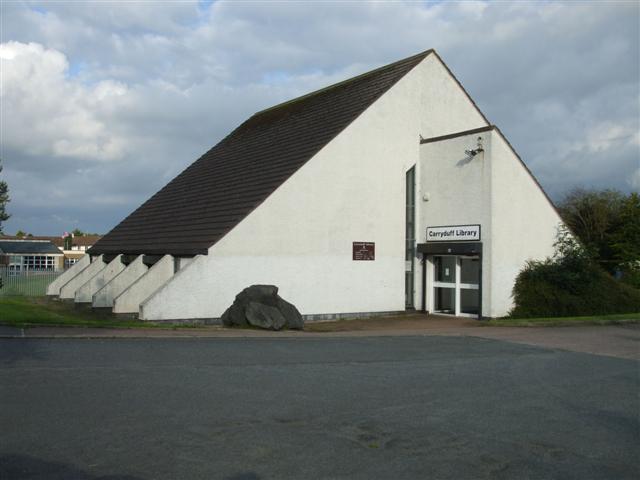
The 1980s saw expansion continue with Carryduff becoming a commuter town for Belfast workers. Developments continued into the 1990s and included Carryduff Library, Carryduff Shopping Centre. These developments saw the Carryduff River placed inside a culvert for much of its journey through the town. Very little green belt land now remains between Carryduff and the southern border of Belfast, the 1980s having seen the former Matthew Stop Line breached.
In 2018, the disused Knockbracken reservoir became Ireland's largest aqua park, offering a range of water based activities.
From the History section of Carryduff on Wikipedia, under CC BY-SA 4.0.
Churches and places of worship7
Church of The Immaculate Heart of Mary
Church · Roman Catholic · 0.9 mi
Knockbracken Drive, Carryduff
Shopping4
Gas and EV charging5
Schools, colleges and libraries4
St Joseph's Primary School
School · Roman Catholic · 0.9 mi
8 Knockbracken Drive, Carryduff
Healthcare1
Map of Carryduff
40 places. The map loads OpenStreetMap tiles when you open it.
Getting there and nearby towns
George Best Belfast City Airport (BHD) is the nearest airport with scheduled flights listed in OpenStreetMap, 7 miles away.
- Saintfield 5 mi southeast, about 7 min by car
- Belfast 6 mi north, about 9 min by car
- Lisburn 6 mi west, about 10 min by car
- Dundonald 6 mi northeast, about 10 min by car
- Comber 6 mi east, about 10 min by car
- Hillsborough 8 mi southwest, about 14 min by car
- Holywood 9 mi north, about 14 min by car
- Newtownards 9 mi northeast, about 15 min by car
- Newtownabbey 10 mi north, about 16 min by car
- Crossgar 10 mi southeast, about 16 min by car
Drive times are estimates from straight-line distance, not routes.
Towns near Carryduff


Keep exploring
Local news
Headlines from INDB.
Reviews, tips and questions
Loading what members have shared...
Sources and licences
- GeoNames (CC BY 4.0): population, coordinates, regions and time zone
- OpenStreetMap contributors (ODbL 1.0): places, airports, map data
- Wikidata (CC0 1.0): elevation, founding date, time zone, website, landmarks and historic places
- Wikimedia Commons (see each image): photos
- Wikipedia (CC BY-SA 4.0): overview and history text
Photo credits
- Giants Ring, Lordjaysus ( talk ), CC BY-SA 3.0
- Carryduff Library, Kenneth Allen, CC BY-SA 2.0
Page built November 10, 2026. Spotted a mistake? Tell us or suggest a place.