
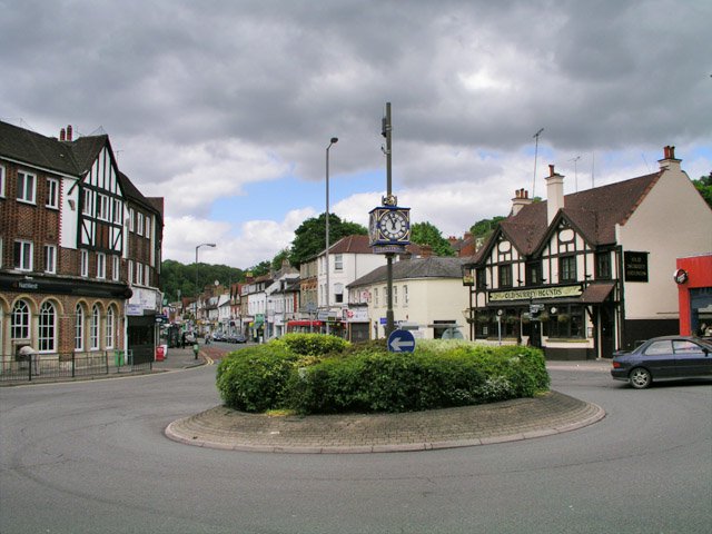


Caterham, United Kingdom
Caterham is a town of 20,957 people in England, United Kingdom.
Why visit Caterham
Townapedia lists 17 museums and landmarks, 25 parks and trails, 42 places to eat, 2 places to stay and 6 attractions in and around town.
Highlights include Miller Centre, Caterham Museum, Bletchingley Castle and Foxley Wood.
Weather in Caterham
Forecast from MET Norway (CC BY 4.0). Full forecast
About Caterham
Caterham () is a town in the Tandridge district of Surrey, England. The town is administratively divided into two: Caterham on the Hill, and Caterham Valley, which includes the main town centre in the middle of a dry valley but rises to equal heights to the south. The town lies close to the A22, 21 miles (34 kilometres) from Guildford and 6 miles (10 kilometres) south of Croydon, in an upper valley cleft into the dip slope of the North Downs. Caterham on the Hill is above the valley to the west.
From the Wikipedia article Caterham (this version), under CC BY-SA 4.0.
Things to do6


Museums and landmarks17


Bletchingley Castle
Monument and historic site · 3.2 mi
Castle in Surrey, England, UK
5 more on the map.
Parks, trails and playgrounds25


Kitchen Copse
Park · 2.0 mi
English private wooded nature reserve in Surrey

Nore Hill Pinnacle
Park · 2.6 mi
Local nature reserve in Surrey, England


13 more on the map.
Restaurants and cafes42


Caffè Nero
Cafe · Coffee Shop
2 Godstone Road, Caterham
Mo-Fr 07:00-17:30; Sa 07:30-18:00; Su 08:00-17:30

The Radius Arms
Bar and pub · 1.9 mi
205 Godstone Road, Whyteleafe
Tu-Th 16:00-21:30; Fr,Sa 14:00-22:30; Su 12:00-17:00

Caterham Chinese Restaurand
Restaurant · Chinese · 1.0 mi
375 Croydon Road, Caterham
30 more on the map.
History
An encampment on the top of White Hill, in Caterham Valley south of Caterham School, between Bletchingley and the town centre is called The Cardinal's Cap which was excavated and inspected in designating it a Scheduled Ancient Monument. With close ramparts forming two or more lines, archaeologists describe the fort as a "large multivallate hillfort at War Coppice Camp".
Read more of the history
Its inner bank is about 0.5m wide and 0.4m high with a ditch 7m wide and 0.3m deep situated 2m below its crest. To the west of the ditch is the second bank, 8m wide and 0.5m high. Beyond this the second ditch has become completely infilled over the years but survives as a buried feature approximately 8m wide, visible as a terrace. Traces of a second, slighter terrace are situated further down the slope, representing evidence of additional scarping. The defences to the north east include an inner bank 5m wide and up to 0.5m high from the interior and 4m high from the exterior with a surrounding ditch 8m wide and 0.6m deep. Beyond this is a counterscarp bank 6m wide and up to 1m high. A 35m long section of a second ditch, which has become partially infilled over the years, survives 25m further out to the north east. In the southern and south eastern areas of the monument, sections of the hillfort have been disturbed by later quarrying activity. Although the monument was originally thought to be either Roman or Neolithic in date, excavations in 1950 showed it to be Iron Age and what had previously been thought to be a fragment of an earthwork was almost complete with the banks of the ramparts having been palisaded and revetted to strengthen their defence.
The town lies within the Anglo-Saxon feudal division of Tandridge hundred.
The origin of the name Caterham is disputed and unknown. One theory is that it derives from the Primitive Welsh word cadeir meaning chair and the Old English hām meaning village. This could be in reference to a chair-shaped hill. Other theories derive it from the Old English cattahām or cattehām meaning 'Catta's settlement' or 'settlement of the cats'.
Caterham's church of St Lawrence is of Norman construction and retains a rector as its incumbent. In the reign of King John, Roger son of Everard de Gaist gave this including its church lands to the monastery of Waltham Holy Cross. Everard's grandfather was Geoffery of Caterham who gave land to his son in the 12th century. This monastery ran the glebe as a manor, receiving a grant of free warren in their demesne lands of Caterham in 1253; holding it until the dissolution of the monasteries.
Caterham's original village centre consisted in the nearest part of the ridge of Caterham on the Hill to the railway station in Caterham Valley, including at the street ascending the relatively steep, short hill, Church Hill. Although no conservation area has been designated in either civil parish, four secular buildings, including The King and Queen public house, three churches as well as a vault and tomb in St Lawrence's churchyard are listed; these are along Hill Street/ Church Hill in Caterham on the Hill.
Porkele had been formerly included in the manor given to Waltham Abbey; together the latter manors comprised 1,000 acres (400 hectares). Humphrey Stafford, 1st Duke of Buckingham (1402–1460) held these manors leaving them in 1458 to his third son John Stafford, 1st Earl of Wiltshire when his son died without issue in 1499, under the terms of grant the elder branch, the following Duke of Buckingham inherited. His heirs sold them on the dissolution to Lord Berners who died in debt in 1533 resulting in bona vacantia and seizure by the Crown. In 1570 Thomas Sackville, 1st Earl of Dorset (as Lord Buckhurst), later Lord High Treasurer, held the 'manor of Caterham and Portele farm,' which he conveyed in that year to Henry Shelley; Sir Thomas's Sondes's widow leased the lands in 1599 to her half-brother, Main Plot seditionist Henry Brooke, 11th Baron Cobham. Then in 1615 her daughter Frances Leveson gave the rest of that lease, due the tenant's attainder to Sir Edward Barrett and Walter Barrett while the reversion was held by Sir Richard Sondes. George Ede purchased this massive estate in 1612 and it passed to Jasper Ockley in 1616. Sir Isaac Shard who was one of two Sheriffs of the City of London in 1730 who conveyed it to Thomas Clark and then passed as with the other manors; in 1911 W. L. Williams its owner lived at Portley in what remained of the estate. De Stafford School in Caterham on the Hill occupies a small part of the estate and is named after the earlier known owner. Adjoining Sunnydown School, state-run, is at what was Portley House and is for secondary education for boys with a Statement of Special Educational Needs.
The only manor did not have as high-profile owners. In 1339 John de Horne released some land in Caterham (and more in Warlingham) to Roger Salaman, who at his death in 1343 was "seised of a tenement". A manor of Salmons appears in 1605 by William Jordan, who soon afterwards acquired the second manor of Caterham (see above) with which Salmons afterwards descended. It was bought out of Chancery, into which it went on the death of Charles Day, by George Drew, who sold to members of the Horne family, who owned the relatively small estate in 1911.
From the History section of Caterham on Wikipedia, under CC BY-SA 4.0.
More about Caterham
Geography
Caterham is 21 miles (34 kilometres) from the county town of Guildford and 15+1⁄2 miles (25 kilometres) south of London.
Caterham on the Hill is located on a considerable area of upland extending north past adjoining Kenley Aerodrome to Kenley and Hartley Hill in Reedham. This elevated area carries on west until Hooley/Old Merstham and forms a very narrow, fairly steep ridge south of Caterham Valley's centre; east of the centre of Caterham Valley are marginally higher rolling pastures of the North Downs on top of a more crevassed smaller mass of upland which forms the village of Woldingham followed by a much larger area of upland stretching from Biggin Hill to Downe and Knockholt, Kent.
The M25 motorway (between junctions 6 and 7) is 80 to 90m below and less than 200m south of the North Downs path and the southern border of Caterham Valley civil parish and is linked by an uninterrupted hilltop dual carriageway to the north of Caterham and its lowest point, Croydon Road roundabout.
Elevations range from the height above in the southwest extreme at "Whitehill Tower, War Coppice Road in Caterham Valley" to 110m Above Ordnance Datum along the railway track, immediately below Croydon Road roundabout, a tripoint partly in Woldingham, Whyteleafe and Caterham.
Arts and culture
A children's ball pit and gymnastics centre are situated in the old Caterham Barracks housing estate. The building is made out of the two converted gymnasiums. There is a skatepark called "Skaterham" in Caterham on The Hill. It has indoor and outdoor sections, built on the grounds of the former Guards Chapel.
Based in the town centre the Miller Centre is a theatre and community centre that puts on regular non-professional shows, films and is host to a number of clubs and community groups. Croydon Gymnastics Club are based in the gymnastics centre on the high street, which also has a dance studio.
The small East Surrey Museum houses a local history collection.
An annual carnival is held in the town, with a procession of floats and a fete.
Caterham has an online radio station for the community, called Ridge Radio.
The first Caterham Festival was in 2009 and by 2014 there were 135 events spread over 5 weeks. There is a 2-day music fest, the High Street is closed for a town street party and the main road through the Valley is closed for a food fest. Other events include Shakespeare plays, an archaeological dig, open Caterham – where buildings and groups open their doors for the weekend, concerts and comedy nights. The annual Carnival takes place during the Festival.
The committee members have also advised many other towns about holding similar Festivals.
Education
Caterham has a mixture of state and private schools. Three private schools in Caterham are Caterham School established at its present site since 1884, which is in the outskirts of the town, Oakhyrst Grange School and Essendene Lodge School. The main state secondary school is de Stafford School. A secondary school for boys with special educational needs called Sunnydown School is also in Caterham on the Hill.
From the Wikipedia article Caterham, under CC BY-SA 4.0.
Notable people from Caterham
 Bill NighyBritish actor (born 1949)Photo: Harald Krichel, CC BY-SA 3.0
- Jon FinchBritish actor (1941/1942–2012)
- Hannah Schmitzstrategist at Red Bull racing
- Olgierd ZienkiewiczBritish academic of Polish descent, mathematician and civil engineer (1921-2009)
- David PriceEnglish former footballer, born 1955
- Nicky ForsterEnglish footballer (born 1973)
- Bev LyonEnglish cricketer (1902-1970)
- Dar LyonEnglish cricketer (1898-1964)
- Shelley HarlandEnglish singer
- Alf Padghamprofessional golfer (1906–1966)
- Mary PorterAustralian politician (born 1942)
- Drummond AllisonWar poet
Born in Caterham, according to Wikidata (CC0). Each name links to its Wikipedia article.
Where to stay2
Churches and places of worship16
Shopping11
Gas and EV charging3
Schools, colleges and libraries23
Healthcare9
Map of Caterham
154 places. The map loads OpenStreetMap tiles when you open it.
Getting there and nearby towns
London Biggin Hill Airport (BQH) is the nearest airport with scheduled flights listed in OpenStreetMap, 6 miles away.
- Kenley 3 mi north, about 5 min by car
- Coulsdon 4 mi northwest, about 6 min by car
- Oxted 4 mi southeast, about 6 min by car
- Sanderstead 4 mi north, about 6 min by car
- Reigate 6 mi southwest, about 10 min by car
- West Wickham 6 mi northeast, about 10 min by car
- Sutton 7 mi northwest, about 11 min by car
- Croydon 7 mi north, about 11 min by car
- Wallington 7 mi northwest, about 10 min by car
- Shirley 7 mi north, about 11 min by car
Drive times are estimates from straight-line distance, not routes.
Towns near Caterham


Keep exploring
Local news
Headlines from INDB.
Reviews, tips and questions
Loading what members have shared...
Sources and licences
- GeoNames (CC BY 4.0): population, coordinates, regions and time zone
- Mapillary (see each image): photos
- OpenStreetMap contributors (ODbL 1.0): places, airports, map data
- Wikidata (CC0 1.0): elevation, founding date, time zone, website, landmarks and historic places
- Wikimedia Commons (see each image): photos
- Wikipedia (CC BY-SA 4.0): overview and history text
Photo credits
- Caterham Roundabout, Hywel Williams, CC BY-SA 3.0
- Foxley Wood 3, Dudley Miles, CC BY-SA 3.0
- Happy Valley Park, Dudley Miles, CC0
- Kitchen Copse (3), Dudley Miles, CC BY-SA 4.0
- Church Of The Sacred Heart Of Jesus, Tag Scientist, CC BY-SA 4.0
- Caterham School, Hywel Williams, CC BY-SA 2.0
- St Lawrence's Church Church, Church Road, Caterham (NHLE Code 1377607), The Voice of Hassocks, CC0
- The King And Queen Public House, Tag Scientist, CC BY-SA 4.0
- St John the Evangelist's Church, Clareville Road, Caterham (NHLE Code 1294940), The Voice of Hassocks, CC0
- North Downs Hospital, Caterham, Surrey, UK, GrimRob, CC0
- Street-level photo, caranteth, CC BY-SA 4.0
- Street-level photo, caranteth, CC BY-SA 4.0


Page built November 10, 2026. Spotted a mistake? Tell us or suggest a place.