



Clevedon, United Kingdom
Clevedon is a town of 21,002 people in England, United Kingdom.
Why visit Clevedon
Townapedia lists 9 museums and landmarks, 16 parks and trails, 54 places to eat, 4 places to stay and 9 attractions in and around town.
Highlights include Curzon Community Cinema, Theatre Shop, Clevedon Court and Clock Tower.
Weather in Clevedon
Forecast from MET Norway (CC BY 4.0). Full forecast
About Clevedon
Clevedon (, KLEEV-dən) is a seaside town and civil parish in North Somerset, England. It lies along the Severn Estuary, among small hills that include Church Hill, Wain's Hill (topped by the remains of an Iron Age hillfort), Dial Hill, Strawberry Hill, Castle Hill, Hangstone Hill and Court Hill, a Site of Special Scientific Interest with overlaid Pleistocene deposits. It is mentioned in the Domesday Book of 1086. In the Victorian period, Clevedon developed into a seaside resort.
From the Wikipedia article Clevedon (this version), under CC BY-SA 4.0.
Travel tips from other travellers: Clevedon on Wikivoyage (CC BY-SA 4.0).
Things to do9


Museums and landmarks9

Clevedon Court
Monument and historic site · 1.1 mi
Grade I listed historic house museum in North Somerset, England, UK



ROC Post Clevedon
Monument and historic site
Royal Observer Corps cold war nuclear fallout shelter and monitoring post. Operational 1959 to 1991.
Parks, trails and playgrounds16




4 more on the map.
Restaurants and cafes54



Cafe Fusion
Cafe · 0.5 mi
22B Old Church Road, Clevedon
Mo-Fr 07:30-16:00; Sa 08:00-16:00
42 more on the map.
History
The name derives from the Old English cleve meaning "cleave" or "cleft" and don meaning "hill".
Wain's Hill is an univallate Iron Age hill fort approximately 1 mile (1.6 km) south-west of Clevedon. The hill fort is defined by a steep, natural slope from the south and north with two ramparts to the east.
The Domesday Book of 1086 mentions Clevedon as a holding of a tenant-in-chief by the name of Mathew of Mortaigne, with eight villagers and ten smallholders. Later, the parish of Clevedon formed part of the Portbury Hundred.
Two small rivers, the Land Yeo and Middle Yeo, supported at least two mills. The Tuck Mills stood in the fields south of Clevedon Court and were used for fulling cloth; other mills near Wain's Hill probably date from the early 17th century.
Victorian Clevedon changed from a farming village into a popular seaside town. Clevedon Pier was completed in 1869 to serve as an embarkation point for paddle steamers. The Victorian craze for sea bathing was met in the late 19th century by saltwater baths (since demolished, though foundations remain), and bathing machines on the main beach near the pier.
Read more of the history
The railway reached Clevedon in 1847 when a branch line from Yatton opened in 1847, six years after the main line. The branch line closed in 1966. The station site is now Queen's Square, a shopping precinct. The town was headquarters also for the Weston, Clevedon and Portishead Light Railway, which connected the three named coastal towns. It opened to Weston-super-Mare in 1897, was extended to Portishead ten years later, but closed in 1940. Its trains crossed the road in the town centre, known as The Triangle, preceded by a man with red and green flags.
Clevedon was the site of St Edith's Children's Home for almost 100 years until it closed in 1974. It was run by nuns of the Community of the Sisters of the Church, an international body in the Anglican Communion living according to the Gospel values of poverty, chastity and obedience. The building on Dial Hill is listed, so that the outside has changed little, but now contains private flats.
The first large-scale production of penicillin took place in the town. In 1938 Howard Florey was working at Lincoln College, Oxford with Ernst Boris Chain and Norman Heatley when he read Alexander Fleming's paper on the antibacterial effects of Penicillium notatum mould. He arranged for this to be grown in deep culture tanks at the Medical Research Council's Antibiotic Research Station in Clevedon, enabling mass production of the mould for a medicine injected into forthcoming World War II soldiers suffering from infections.
From the History section of Clevedon on Wikipedia, under CC BY-SA 4.0.
More about Clevedon
Geography
Clevedon is situated on and round seven hills called Church Hill, Wain's Hill (topped by the remains of an Iron Age hill fort), Dial Hill, Strawberry Hill, Castle Hill, Hangstone hill and Court Hill, the last a Site of Special Scientific Interest. On a clear day there are far-reaching views across the Severn estuary to Wales. When visibility is good, the islands of Steep Holm and Flat Holm in the Bristol Channel can be seen. The tidal rise and fall in the Severn Estuary and Bristol Channel can be as great as 14.5 m (48 ft), second only to Bay of Fundy in Eastern Canada.
The seafront runs about half a mile from the pier to Salthouse Field, with ornamental gardens, a Victorian bandstand, a bowling green, tennis courts, crazy golf and other amusements. Marine Lake, once a Victorian swimming pool, is used for boating and for a small festival once a year where people can try out new sports. Salthouse Field once had a light railway round its perimeter and is used for summer donkey rides.
Economy
Clevedon has light industry, mainly on industrial estates such as Hither Green, near the M5 motorway junction. It is also a dormitory town for Bristol. The Clerical Medical pensions and investments group, part of HBOS, was based in the town on the former site of the Hales Cakes factory, but after its closure in 2009, North Somerset Council bought the Castlewood offices for their own use. Percy Daniel & Co are organ builders, whose work includes that of Brentwood Cathedral.
Yeates Removals was set up in 1910, using horses and carts for general haulage in Clevedon and surrounding areas. The company has always been run by family members.
Arts and culture
Writers linked with the town include Samuel Taylor Coleridge, who spent some months in a cottage in Clevedon, after his marriage to Sara Fricker, William Makepeace Thackeray, a frequent guest of the Elton family at Clevedon Court, and George Gissing (The Odd Women is set here).
The final scene of a 1993 movie, The Remains of the Day, starring Anthony Hopkins, Emma Thompson and Christopher Reeve, refers to Clevedon, where it was filmed. The television movie Cider with Rosie (1998) also has scenes filmed there. Scenes from the 2010 film, Never Let Me Go, starring Keira Knightley were filmed in Clevedon in the summer of 2009. Clevedon has its comic book superhero, Captain Clevedon.
Clevedon has been twinned with Ettlingen, in Baden-Württemberg, Germany, since 1980, Épernay, France, since 1990, and Middelkerke, Belgium, since 1991.
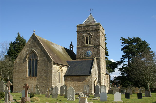
Clevedon, in particular St Andrew's Church, was one of the settings for the town Broadchurch, a detective drama first aired on ITV on 4 March 2013.
Education
Clevedon School is a secondary comprehensive school serving the town and surrounding rural areas, with some 1,200 pupils in years 7 to 11 (Lower School) and 12 to 13 (Upper School or sixth form).
There are six primary schools: Mary Elton Primary School, St John the Evangelist of Bath and Wells Academy Trust Church of England School, All Saints C of E Primary School and St Nicholas's Chantry CEVC Primary School.
Mary Elton (née Stewart of Castle Stewart), the second wife of the Reverend Sir Abraham Elton, endowed local schools in the 19th century: the Mary Elton Primary School in Holland Road, Clevedon, is named after her.
St John's the Evangelist Primary School was formerly based on the current site of Clevedon Library. It moved to its current site on the Fosseway in 1991 and was opened by Anne, Princess Royal.
Yeo Moor Primary School, opened on 19 April 2010, amalgamated infant and junior schools that shared the site. The footballer Jack Butland attended Yeo Moor School and Clevedon School.
St Brandon's School was an independent boarding school until 1991 and a co-educational infant and junior school until 2004.
A drama company, Take The Lead, from Clevedon School, has put on productions in the town.
From the Wikipedia article Clevedon, under CC BY-SA 4.0.
Notable people from Clevedon
 Jan MorrisWelsh historian, author and travel writer (1926–2020)Photo: Unknown author Unknown author, Public domain
 Edward Raymond TurnerBritish inventor and cinematographer (1873–1903)Photo: Unknown author Unknown author, Public domain
 George Paul ShelleyBritish singerPhoto: InfoGibraltar, CC BY 2.0
 Mark BuckinghamBritish comic book artistPhoto: Qwertzu111111, CC BY-SA 4.0
 Justin PipeEnglish darts playerPhoto: Professional Darts Corporation, CC BY 3.0
 Christopher TamblingBritish composer, organist and choirmasterPhoto: Adippold, CC BY-SA 4.0
- Edward TysonEnglish scientist and physician, 1651–1708
- Gareth MorrisBritish musician (1920–2007)
- George Eric Rowe GedyeBritish journalist and author (1890–1970)
- Jerry GillBritish footballer (born 1970)
- John MarrackBritish pathologist
- David Bryantbowls champion
Born in Clevedon, according to Wikidata (CC0). Each name links to its Wikipedia article.
Where to stay4
Warrens Village Motel and Self Catering
Motel and hotel · 1.5 mi
Colehouse Lane, Bristol
Churches and places of worship23
Shopping22
Gas and EV charging2
Schools, colleges and libraries8
St Nicholas Chantry Church of England Primary School
School · Anglican · 0.6 mi
Highdale Avenue, Clevedon
Healthcare7
Map of Clevedon
154 places. The map loads OpenStreetMap tiles when you open it.
Getting there and nearby towns
Bristol Airport (BRS) is the nearest airport with scheduled flights listed in OpenStreetMap, 7 miles away.
- Yatton 4 mi south, about 6 min by car
- Nailsea 4 mi east, about 7 min by car
- Portishead 5 mi northeast, about 8 min by car
- Bristol 11 mi east, about 18 min by car
- Newport 12 mi northwest, about 19 min by car
- Cardiff 14 mi west, about 23 min by car
- Stoke Gifford 15 mi east, about 23 min by car
- Keynsham 16 mi east, about 25 min by car
- Thornbury 19 mi northeast, about 30 min by car
- Wells 19 mi southeast, about 30 min by car
Drive times are estimates from straight-line distance, not routes.
Towns near Clevedon


Keep exploring
Local news
Headlines from INDB.
Reviews, tips and questions
Loading what members have shared...
Sources and licences
- GeoNames (CC BY 4.0): population, coordinates, regions and time zone
- Mapillary (see each image): photos
- OpenStreetMap contributors (ODbL 1.0): places, airports, map data
- Wikidata (CC0 1.0): elevation, founding date, time zone, website, landmarks and historic places
- Wikimedia Commons (see each image): photos
- Wikipedia (CC BY-SA 4.0): overview and history text
Photo credits
- ClevedonFromAir2007, The original uploader was Icrutt at English Wikipedia ., CC BY-SA 3.0
- Horses and Carts used for general haulage 1910 Clevedon UK, Yeates Removals, CC BY-SA 2.5
- Clevedon 1 (rear 2005), Arthur266, CC BY-SA 3.0
- Kingston Seymour All Saints church, NotFromUtrecht, CC BY-SA 3.0
- Weston in Gordano church, Adrian and Janet Quantock, CC BY-SA 2.0
- Church of St Quiricus and St Juliet Tickenham, Linda Bailey, CC BY-SA 2.0
- St John the Evangelist's Church, Clevedon, Somerset (4837480300), Robert Cutts from Bristol, England, CC BY 2.0
- Kenn church, Adrian and Janet Quantock, CC BY-SA 2.0
- Christ Church Clevedon, Beikul, CC BY-SA 3.0
- ClevedonSchool, Adrian and Janet Quantock, CC BY-SA 2.0
- Clevedon Clock Tower, Feltpatpat5, CC BY-SA 4.0
- Clevedon Curzon cinema, The original uploader was Andrew Norman at English Wikipedia ., Public domain
- North Somerset Community Hospital, Mojo0306, CC BY-SA 4.0
- Street-level photo, southglos, CC BY-SA 4.0
- Street-level photo, southglos, CC BY-SA 4.0
- Street-level photo, southglos, CC BY-SA 4.0
- Street-level photo, southglos, CC BY-SA 4.0
- Street-level photo, southglos, CC BY-SA 4.0
- Street-level photo, southglos, CC BY-SA 4.0
- Street-level photo, southglos, CC BY-SA 4.0
- Street-level photo, southglos, CC BY-SA 4.0
- Street-level photo, southglos, CC BY-SA 4.0
- Street-level photo, southglos, CC BY-SA 4.0
- Street-level photo, southglos, CC BY-SA 4.0
- Street-level photo, southglos, CC BY-SA 4.0
- Street-level photo, southglos, CC BY-SA 4.0
- Street-level photo, southglos, CC BY-SA 4.0
- Street-level photo, southglos, CC BY-SA 4.0
- Street-level photo, southglos, CC BY-SA 4.0
- Street-level photo, southglos, CC BY-SA 4.0
- Street-level photo, southglos, CC BY-SA 4.0


Page built November 10, 2026. Spotted a mistake? Tell us or suggest a place.