
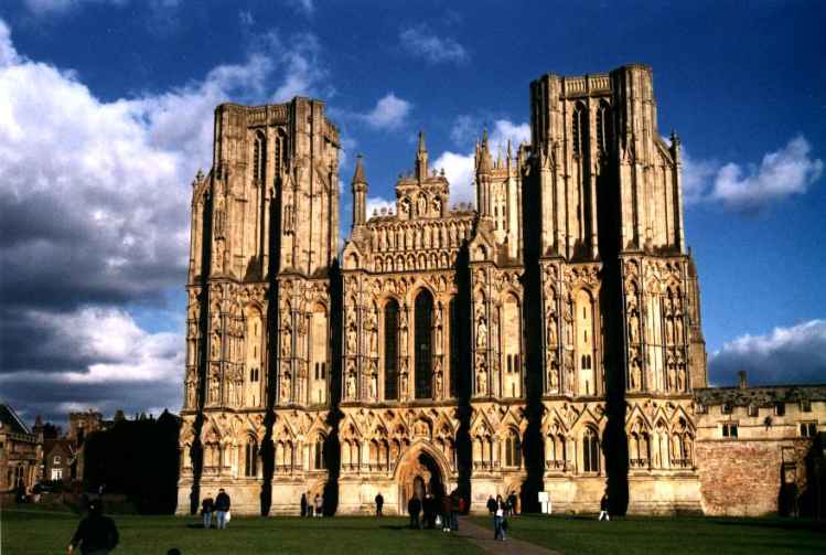


Why visit Wells
Townapedia lists 10 museums and landmarks, 3 parks and trails, 43 places to eat, 11 places to stay and 5 attractions in and around town.
Highlights include Wells Film Centre, Wookey Hole Caves, Brown's Gatehouse and Chain Gate.
Weather in Wells
Forecast from MET Norway (CC BY 4.0). Full forecast
About Wells
Wells () is a cathedral city and civil parish in Somerset, England. It is located on the southern edge of the Mendip Hills, 22 miles (35 km) south-west of Bath, 23 miles (37 km) south of Bristol, and 24 miles (39 km) north-east of Taunton. At the 2021 census, the population of the parish was 11,145 and the population of the built-up area, which extends into the neighbouring parish of St Cuthbert Out, was 12,105.
From the Wikipedia article Wells, Somerset (this version), under CC BY-SA 4.0.
Travel tips from other travellers: Wells on Wikivoyage (CC BY-SA 4.0).
Photos of Wells

Things to do5

Wookey Hole Caves
Monument and historic site · 1.7 mi
Series of limestone caverns in Somerset county, England


Museums and landmarks10


The Bishop's Palace and Gardens
Museum
Grade I listed house in Wells, Somerset, England, UK run by The Palace Trust

Wells and Mendip Museum
Museum
Museum in Wells, Somerset, United Kingdom


King's Castle
Monument and historic site · 1.3 mi
Iron Age enclosed hilltop settlement in Somerset, England, UK
Parks, trails and playgrounds3



Restaurants and cafes43



31 more on the map.
History
The city was a Roman settlement that became an important centre under the Anglo-Saxons when King Ine of Wessex founded a minster church in 704. Two hundred years later, in 909, it became the seat of the newly formed bishopric of Wells; but in 1090, the bishop's seat was removed to Bath. The move caused severe arguments between the canons of Wells and the monks of Bath until 1245 when the bishopric was renamed the Diocese of Bath and Wells, to be elected by both religious houses. With the construction of the current cathedral and the bishop's palace in the first half of the 13th century, under the direction of Bishop Reginald and later Bishop Jocelin, a native of the city, Wells became the principal seat of the diocese.
The 8th-century port at Bleadney on the River Axe enabled goods to be brought to within 3 mi (5 km) of Wells. In the Middle Ages overseas trade was carried out from the port of Rackley. In the 14th century a French ship sailed up the river, and by 1388 Thomas Tanner from Wells used Rackley to export cloth and corn to Portugal, and received iron and salt in exchange. Wells had been a centre for cloth making; however, in the 16th and 17th centuries this diminished, but the city retained its important market focus. Wells in the 19th century had the largest cheese market in the west of England.
Read more of the history
Wells was listed in the Domesday Book of 1086 as Welle, from the Old English wiells, not as a town but as four manors with a total of 132 households, which implies a population of around 500–600. Earlier names for the settlement have been identified which include Fontanetum, in a charter of 725 granted by King Ina to Glastonbury and Fontanensis Ecclesia. "Tidesput" or "Tithesput furlang" relates to the area east of the bishop's garden in 1245. Wells was part of, and gave its name to, the hundred of Wells Forum.
Wells had been granted charters to hold markets by Bishop Robert (1136–66) and free burgage tenure was granted by Bishop Reginald (1174–1191). Wells was recognised as a free borough by a Royal charter of King John in 1201. The city remained under episcopal control until its charter of incorporation from Queen Elizabeth I in 1589. City status was most recently confirmed by Queen Elizabeth II by letters patent issued under the Great Seal dated 1 April 1974, which granted city status specifically to the civil parish; on that date major local government reorganisation came into effect, which involved the abolition of the municipal borough of Wells.
Anne of Denmark, the wife of King James came to Wells on 20 August 1613. She was entertained by a pageant performed by the town's trades and crafts. The blacksmiths presented Vulcan's forge. The butchers made a tableau of "old virgins", with their attires made of cow tails and necklaces made of cow's horns, who were drawn in a chariot by men and boys dressed in ox skins. The mayor, William Bull, held a dinner for members of the queen's household including her four maids of honour. The Venetian ambassador Antonio Foscarini recorded her delight.
During the English Civil War (1642–1651), at what became known as the "Siege of Wells", the city found itself surrounded by Parliamentarian guns on the Bristol, Glastonbury and Shepton Mallet sides. Col. William Strode had 2,000 men and 150 horse. The Royalists evacuated the city. Parliamentarian troops then used the cathedral to stable their horses and damaged much of the ornate sculpture by using it for firing practice.
William Penn stayed in Wells shortly before leaving for America (1682), spending a night at The Crown Inn. Here he was briefly arrested for addressing a large crowd in the market place, but released on the intervention of the Bishop of Bath and Wells. During the Monmouth Rebellion (1685) the rebel army attacked the cathedral in an outburst against the established church and damaged the west front. Lead from the roof was used to make bullets, windows were broken, the organ smashed and horses stabled in the nave. Wells was the final location of the Bloody Assizes on 23 September 1685. In a makeshift court lasting only one day, over 500 men were tried and the majority sentenced to death.
Wells' first station, Priory Road, opened in 1859 on the Somerset Central Railway (later the Somerset & Dorset Joint Railway, S&DJR) as the terminus of a short branch from Glastonbury. A second railway, the East Somerset, opened a branch line from Witham in 1862 and built Wells East Somerset station to the east of Priory Road. In 1870, the Cheddar Valley line branch of the Bristol & Exeter Railway from Yatton, reached Wells and built a third station at Tucker Street. Matters were simplified when the Great Western Railway acquired the Cheddar Valley and the East Somerset lines and built a link between them that ran through the S&DJR's Priory Road station. In 1878, when through trains began running between Yatton and Witham, the East Somerset station closed, but through trains did not stop at Priory Road until 1934. Priory Road closed to passenger traffic in 1951 when the S&DJR branch line from Glastonbury was shut, though it remained the city's main goods depot. Tucker Street closed in 1963 under the Beeching cuts, which closed the Yatton to Witham line to passengers. Goods traffic to Wells ceased in 1964. Southern Railway West Country class steam locomotive no 34092 was named City of Wells at a ceremony at Priory Road station in 1949. It was used to haul the Golden Arrow service between London and Dover. It was withdrawn from service in 1964, and rescued from a scrapyard in 1971, and as August 2021 was operational on the East Lancashire Railway.
During World War II, Stoberry Park in Wells was the location of a prisoner-of-war camp, housing Italian prisoners from the Western Desert Campaign, and later German prisoners after the Battle of Normandy. Penleigh Camp on the Wookey Hole Road was a German working camp.
From the History section of Wells, Somerset on Wikipedia, under CC BY-SA 4.0.
More about Wells
Geography
Wells lies at the foot of the southern escarpment of the Mendip Hills where they meet the Somerset Levels. The hills are largely made of carboniferous limestone, which is quarried at several nearby sites. In the 1960s, the Mendip television transmitter, was installed on Pen Hill above Wells, approximately two miles (three kilometres) from the centre of the city.
Streams passing through caves on the Mendip Hills, including Thrupe Lane Swallet and Viaduct Sink (approximately 5 km or 3 mi east of the city), emerge at Saint Andrew's Well in the garden of the Bishop's Palace, from where the water fills the moat around the Palace and then flows into Keward Brook, which carries it for approximately a mile west to the point where the brook joins the River Sheppey in the village of Coxley.
Economy
Following construction of the A39/A371 bypass, the centre of the city has returned to being that of a quiet market town. It has all the modern conveniences plus shops, hotels and restaurants. Wells is a popular tourist destination, due to its historical sites, its proximity to Bath, Bristol, Stonehenge and Glastonbury and its closeness to the Somerset coast. Also nearby are Wookey Hole Caves, the Mendip Hills and the Somerset Levels. Somerset cheese, including Cheddar, is made locally. Wells is part of the Wells and Shepton Mallet travel to work area which also includes Glastonbury, Cheddar and surrounding areas.
The historic part of the city has often been used for filming both documentaries and many period films and television series, including some with very large productions. Recent examples (2014 to 2017) include filming for Series 2 of Poldark, Dunkirk, Another Mother's Son, Broadchurch, The Levelling, Mum's List, and The White Princess. In addition to Wells Cathedral, the Bishop's Palace, Wells is particularly popular among productions, with filming at the latter conducted (in 2015–2016) for The Huntsman: Winter's War, Galavant, Terry and Mason's The Great British Food Trip, Escape to the Country, and Holiday of My Lifetime.
Arts and culture
Wells and Mendip Museum includes many historical artefacts from the city and surrounding Mendip Hills. Wells is part of the West Country Carnival circuit.
Wells Film Centre shows current releases and, in conjunction with the Wells Film Society shows less well-known and historical films. The previous cinema, The Regal in Priory Road, closed in 1993 and is now Kudos Nightclub. It was built in 1935 by ES Roberts from Flemish bond brickwork with Art Deco features. It is a Grade II listed building, and was on the Buildings at Risk Register until its restoration which included the restoration and repair of the stained glass façade. Wells Little Theatre is operated by a voluntary society which started in 1902. In 1969 they took over the old boy's building of Wells Blue School, where they put on a variety of operatic and other productions.
Milton Lodge is a house overlooking the city. It has a terraced garden, which was laid out in the early 20th century, is listed as Grade II on the Register of Historic Parks and Gardens of special historic interest in England.
Education
The Blue School, founded in 1641, is a state coeducational comprehensive school and has been awarded Specialist science college status. It has 1,641 students aged 11–18 of both sexes and all ability levels.
Wells Cathedral School, founded in 909, is a private school that has a Christian emphasis and is one of the five established musical schools for school-age children in Britain. The school has over 700 pupils between the ages of 3 and 18. The school's boarding houses line the northern parts of the city and the music school retains close links with Wells Cathedral. The primary schools in Wells are Stoberry Park School, St Cuthbert's Church of England Infants School, St Cuthbert's Church of England Junior School and St Joseph and St Teresa Catholic Primary School.
From the Wikipedia article Wells, Somerset, under CC BY-SA 4.0.
Notable people from Wells
 Mary RandBritish track and field athlete and Olympic champion (1940-2026)Photo: Eric Koch for Anefo, CC BY-SA 3.0 nl
 Rachel AthertonEnglish cyclistPhoto: Courtney Nash, CC BY 2.0
 Thomas LinleyBritish composerPhoto: Thomas Gainsborough, Public domain
 James KeeneEnglish footballer (born 1985)Photo: Andreas Nilelind, CC BY-SA 4.0
 Hugh Wardell-YerburghBritish rower (1938–1970)Photo: Kroon, Ron for Anefo, CC0
 John HoskinsEnglish miniature painter (ca. 1590-1665)Photo: John Hoskins, Public domain
 Hugh of WellsBishop of LincolnPhoto: TTaylor, CC BY 2.5
- Elizabeth GoudgeEnglish fiction writer (1900-1984)
- Jack BucknerBritish athletics competitor (born 1961)
- Annie Campbell-OrdeBritish rower
- George BullEnglish Bishop of St David's
- Michael George Henry BarkerBritish Army general
Born in Wells, according to Wikidata (CC0). Each name links to its Wikipedia article.
Where to stay11
Churches and places of worship17
Shopping9
Gas and EV charging3
Schools, colleges and libraries7
St Cuthbert's Church of England Academy Infants and Pre-School
School · Anglican · 0.5 mi
Keward Walk, Wells
Healthcare4
Map of Wells
112 places. The map loads OpenStreetMap tiles when you open it.
Getting there and nearby towns
Bristol Airport (BRS) is the nearest airport with scheduled flights listed in OpenStreetMap, 12 miles away.
- Yatton 15 mi northwest, about 23 min by car
- Bristol 17 mi north, about 28 min by car
- Bath 17 mi northeast, about 27 min by car
- Westbury 20 mi east, about 33 min by car
- Yate 25 mi northeast, about 40 min by car
- Cardiff 30 mi northwest, about 48 min by car
- Newport 30 mi northwest, about 49 min by car
- Royal Wootton Bassett 40 mi northeast, about 1 h by car
- Swindon 45 mi northeast, about 1 h 15 min by car
- Poole 45 mi southeast, about 1 h 15 min by car
Drive times are estimates from straight-line distance, not routes.
Towns near Wells


Keep exploring
Local news
Headlines from INDB.
Reviews, tips and questions
Loading what members have shared...
Sources and licences
- GeoNames (CC BY 4.0): population, coordinates, regions and time zone
- Mapillary (see each image): photos
- OpenStreetMap contributors (ODbL 1.0): places, airports, map data
- Wikidata (CC0 1.0): elevation, founding date, time zone, website, landmarks and historic places
- Wikimedia Commons (see each image): photos
- Wikipedia (CC BY-SA 4.0): overview and history text
Photo credits
- Wells Cathedral West Front, Unknown author, CC BY-SA 3.0
- Church of St Mary Magdalene, Wookey Hole, Somerset, Ashley Smith, CC BY-SA 4.0
- Wookey church, ChurchCrawler, CC BY-SA 2.0
- Dinder Church, Somerset, Wehha, CC BY-SA 3.0
- Church of St Thomas, Wells distance, Rodw, CC BY-SA 3.0
- Former church of St John the Evangelist, East Horrington, Somerset, Ashley Smith, CC BY-SA 4.0
- Wells and Mendip Museum, Rodw, Public domain
- Wells Cathedral West Front Exterior, UK - Diliff, Diliff, CC BY-SA 3.0
- Brown's Gatehouse, Derek Andrews, CC BY-SA 3.0
- Penniless Porch, Derek Andrews, CC BY-SA 3.0
- Blue school Wells, Rodw, Public domain
- Chain gate Wells, Derek Andrews, CC BY-SA 3.0
- Wells - City Arms Inn - 20220926181549, Eddie Johnston, CC BY-SA 4.0
- Chain Gate, Wells, Rodw, CC BY-SA 3.0
- The Bishops Palace And Gardens Long Gallery (49850125312), Michael D Beckwith from England, CC0
- The Bishops Palace and Gardens Entrance (43674417072), Michael D Beckwith, CC0
- Wells. Market Place, Enrique Íñiguez Rodríguez ( Qoan ) Credit information This work was created by Enrique Íñiguez ( Qoan ). You are free to use it for any purpose as long as you credit me properly (e.g. © Enrique..., CC BY-SA 4.0
- Street-level photo, southglos, CC BY-SA 4.0
- Street-level photo, southglos, CC BY-SA 4.0
- Street-level photo, southglos, CC BY-SA 4.0
- Street-level photo, southglos, CC BY-SA 4.0
- Street-level photo, southglos, CC BY-SA 4.0
- Street-level photo, southglos, CC BY-SA 4.0
- Street-level photo, southglos, CC BY-SA 4.0
- Street-level photo, southglos, CC BY-SA 4.0
- Street-level photo, southglos, CC BY-SA 4.0
- Street-level photo, southglos, CC BY-SA 4.0
- Street-level photo, southglos, CC BY-SA 4.0
- Street-level photo, southglos, CC BY-SA 4.0
- Street-level photo, southglos, CC BY-SA 4.0
- Street-level photo, southglos, CC BY-SA 4.0
- Street-level photo, southglos, CC BY-SA 4.0
- Street-level photo, southglos, CC BY-SA 4.0
- Street-level photo, southglos, CC BY-SA 4.0
- Street-level photo, southglos, CC BY-SA 4.0
- Street-level photo, southglos, CC BY-SA 4.0
- Street-level photo, southglos, CC BY-SA 4.0
- Street-level photo, southglos, CC BY-SA 4.0
- Street-level photo, southglos, CC BY-SA 4.0
- Street-level photo, southglos, CC BY-SA 4.0


Page built November 10, 2026. Spotted a mistake? Tell us or suggest a place.