


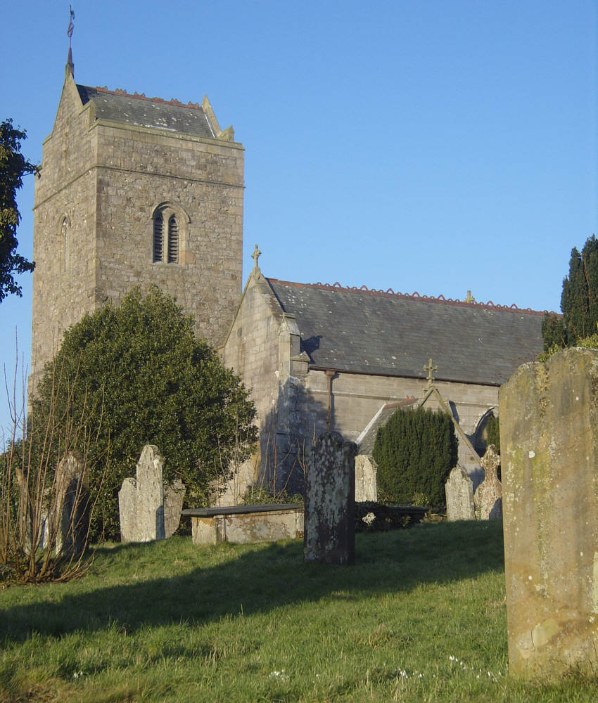

Why visit Dearham
Townapedia lists 9 museums and landmarks, 7 places to eat, 2 places to stay and 3 attractions in and around town.
Highlights include Maryport New Lighthouse, Maryport Old Lighthouse and Alauna.
Weather in Dearham
Forecast from MET Norway (CC BY 4.0). Full forecast
About Dearham
Dearham is a village and civil parish in Cumbria, historically part of Cumberland, near the Lake District National Park in England. It lies about 2 miles (3.2 km) east of Maryport and 5 miles (8.0 km) west of Cockermouth. At the 2021 census, the parish had a population of 2,151.
From the Wikipedia article Dearham (this version), under CC BY-SA 4.0.
Things to do3



Museums and landmarks9

Alauna
Monument and historic site · 2.0 mi
Roman fort and settlement on the site of present-day Maryport in Cumbria, England, UK

Restaurants and cafes7


Where to stay2

History
With its resources of coal and easy access to railways, Dearham is part of Cumberland's former coal mining industry. It saw its population increase from 515 in 1821 to 2,598 in 1891 due to the expansion of coal mining. However, with the decline of deep mining and, later, open cast working, the coal industry ceased to be a source of employment in the area.
Historically, Dearham was in the Workington division of the County of Cumberland, in the ward of Allerdale below Derwent. It belonged to the Derwent Petty sessional division, Cockermouth Union and the County Court district of Cockermouth and Workington.
The village also belongs to the rural deanery of Maryport, the Archdeacon of West Cumberland and the Diocese of Carlisle.
From the History section of Dearham on Wikipedia, under CC BY-SA 4.0.
More about Dearham
Education
The village has a primary school with approximately 253 children on roll and a nursery with approximately 26 children on roll.
The majority of young people in Dearham attend Netherhall School, Maryport, Cockermouth School, Cockermouth and Keswick School, Keswick for their secondary schooling.
From the Wikipedia article Dearham, under CC BY-SA 4.0.
Notable people from Dearham
 John CuthbertsonEnglish instrument maker, 1743 - 1821 (1743–1821)Photo: McSmit, Public domain
- Alvin AckerleyEnglish rugby league footballer
Born in Dearham, according to Wikidata (CC0). Each name links to its Wikipedia article.
Churches and places of worship4
Shopping1
Gas and EV charging1
Schools, colleges and libraries2
Map of Dearham
29 places. The map loads OpenStreetMap tiles when you open it.
Getting there and nearby towns
Carlisle Lake District Airport (CAX) is the nearest airport with scheduled flights listed in OpenStreetMap, 30 miles away.
- Workington 6 mi southwest, about 10 min by car
- Whitehaven 13 mi southwest, about 20 min by car
- Saint Bees 16 mi south, about 26 min by car
- Seascale 22 mi south, about 35 min by car
- Carlisle 24 mi northeast, about 38 min by car
- Dumfries 26 mi north, about 41 min by car
- Wetheral 27 mi northeast, about 44 min by car
- Penrith 28 mi east, about 44 min by car
- Ulverston 38 mi south, about 1 h by car
- Kendal 39 mi southeast, about 1 h by car
Drive times are estimates from straight-line distance, not routes.
Towns near Dearham


Keep exploring
Local news
Headlines from INDB.
Reviews, tips and questions
Loading what members have shared...
Sources and licences
- GeoNames (CC BY 4.0): population, coordinates, regions and time zone
- Mapillary (see each image): photos
- OpenStreetMap contributors (ODbL 1.0): places, airports, map data
- Wikidata (CC0 1.0): elevation, founding date, time zone, website, landmarks and historic places
- Wikimedia Commons (see each image): photos
- Wikipedia (CC BY-SA 4.0): overview and history text
Photo credits
- St Mungo's Church, Dearham, Alexander P Kapp, CC BY-SA 2.0
- Maryport Lighthouse - panoramio, Michael Walsh, CC BY 3.0
- Senhouse Museum, Maryport, UK (38440864335), Carole Raddato from Frankfurt, Germany, CC BY-SA 2.0
- Brigham-church, David Trochos, CC BY-SA 4.0
- Maryport Old Lighthouse 2021 01, Julian Herzog ( Website ), CC BY 4.0
- Street-level photo, jethro10, CC BY-SA 4.0
- Street-level photo, blind_leader, CC BY-SA 4.0
- Street-level photo, blind_leader, CC BY-SA 4.0
- Street-level photo, blind_leader, CC BY-SA 4.0
- Street-level photo, blind_leader, CC BY-SA 4.0
- Street-level photo, blind_leader, CC BY-SA 4.0
- Street-level photo, blind_leader, CC BY-SA 4.0
Page built November 10, 2026. Spotted a mistake? Tell us or suggest a place.