

Dickleburgh, United Kingdom
Dickleburgh is a town of 1,096 people in England, United Kingdom.
Why visit Dickleburgh
Townapedia lists 7 museums and landmarks and 3 places to eat in and around town.
Highlights include The 100th Bomb Group Memorial Museum and 100th Bomb Group Memorial Museum.
Weather in Dickleburgh
Forecast from MET Norway (CC BY 4.0). Full forecast
About Dickleburgh
Dickleburgh is a village and former civil parish, now in the parish of Dickleburgh and Rushall, in the South Norfolk district of the English county of Norfolk.
From the Wikipedia article Dickleburgh (this version), under CC BY-SA 4.0.
Museums and landmarks7

The 100th Bomb Group Memorial Museum
Museum · 1.3 mi
Common Road, Diss
Mar-Oct Sa-Su 10:00-17:00; PH 10:00-17:00, May-Sep We 10:00-17:00
100th Bomb Group Memorial Museum
Museum · 1.4 mi
Independent museum in the East of England

Restaurants and cafes3

Churches and places of worship5

St Andrew's Church, Frenze
Church · 2.3 mi
Church in Frenze, Norfolk, England, UK
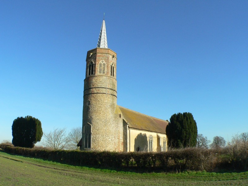
St George's Church, Shimpling
Church · 0.7 mi
Church in Shimpling, Norfolk, England, UK

Schools, colleges and libraries1

History
Dickleburgh is situated upon what was once Pye Road, the Roman road that ran from Venta Icenorum, near Caistor St Edmund, to Camulodunum, now Colchester.
Dickleburgh's name is of Anglo-Saxon origin and derives from the Old English for 'Dicle's' or 'Dicla's' fortification.
In the Domesday Book of 1086, Dickleburgh is listed as a settlement of 22 households in the hundred of Diss. In 1086, the village was part of the estates of St. Edmunds Abbey.
In 1780 Dickleburgh Mill opened, which was turned into one of Britain's first steam-powered mills in 1834. The mill continued to expand throughout the nineteenth and twentieth centuries, generating its own electricity and providing subsidised housing for employees in the village. The mill closed in 1988 with the land being bought by Wimpey Homes for residential redevelopment.
From the History section of Dickleburgh on Wikipedia, under CC BY-SA 4.0.
More about Dickleburgh
Geography
On 1 April 1936 the parish of Rushall was merged with Dickleburgh on 21 January 1980 the parish was renamed "Dickleburgh & Rushall". In 1931 the parish of Dickleburgh (prior to the merge) had a population of 679.
According to the 2021 census, the ward of Dickleburgh has a total population of 1,166 people which demonstrates an increase from the 1,096 people listed in the 2011 census.
From the Wikipedia article Dickleburgh, under CC BY-SA 4.0.
Notable people from Dickleburgh
- George CattermoleBritish artist (1800-1868)
- Henry WaltonBritish painter and art dealer (1746–1813)
Born in Dickleburgh, according to Wikidata (CC0). Each name links to its Wikipedia article.
Map of Dickleburgh
16 places. The map loads OpenStreetMap tiles when you open it.
Getting there and nearby towns
RAF Honington (BEQ) is the nearest airport with scheduled flights listed in OpenStreetMap, 18 miles away.
- Scole 2 mi southwest, about 4 min by car
- Diss 3 mi southwest, about 6 min by car
- Attleborough 11 mi northwest, about 18 min by car
- Haughley 15 mi southwest, about 25 min by car
- Stowmarket 16 mi southwest, about 26 min by car
- Norwich 17 mi north, about 27 min by car
- Bowthorpe 17 mi north, about 27 min by car
- Beccles 17 mi east, about 27 min by car
- Woolpit 17 mi southwest, about 28 min by car
- Thetford 18 mi west, about 30 min by car
Drive times are estimates from straight-line distance, not routes.
Towns near Dickleburgh


Keep exploring
Local news
Headlines from INDB.
Reviews, tips and questions
Loading what members have shared...
Sources and licences
- GeoNames (CC BY 4.0): population, coordinates, regions and time zone
- Mapillary (see each image): photos
- OpenStreetMap contributors (ODbL 1.0): places, airports, map data
- Wikidata (CC0 1.0): elevation, founding date, time zone, website, landmarks and historic places
- Wikimedia Commons (see each image): photos
- Wikipedia (CC BY-SA 4.0): overview and history text
Photo credits
- Thorpe Abbotts Control Tower, Deben Dave, Public domain
- Shimpling-g6, Bernd Jatzwauk Pommes104, CC BY-SA 3.0
- Street-level photo, smsm1, CC BY-SA 4.0
- Street-level photo, smsm1, CC BY-SA 4.0
- Street-level photo, smsm1, CC BY-SA 4.0
- Street-level photo, smsm1, CC BY-SA 4.0
- Street-level photo, IpswichEdits, CC BY-SA 4.0
Page built November 10, 2026. Spotted a mistake? Tell us or suggest a place.