



East Bridgford, United Kingdom
East Bridgford is a town of 1,814 people in England, United Kingdom.
Why visit East Bridgford
Townapedia lists 5 museums and landmarks, 6 parks and trails, 11 places to eat, 3 places to stay and 1 attraction in and around town.
Highlights include Gunthorpe Bridge, Margidunum Roman Station, Margidunum and Kingfisher Wharf.
Weather in East Bridgford
Forecast from MET Norway (CC BY 4.0). Full forecast
About East Bridgford
East Bridgford is a village and civil parish in the Rushcliffe borough of Nottinghamshire, east of the city of Nottingham. It had a population of 1,814 at the 2011 census, falling to 1,763 at the 2021 census. The village adjoins the south bank of the River Trent, opposite the village of Gunthorpe. It is on the Trent Valley Way.
From the Wikipedia article East Bridgford (this version), under CC BY-SA 4.0.
Things to do1
Museums and landmarks5

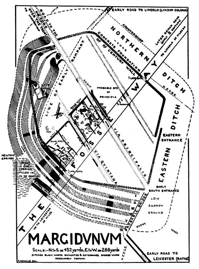
Margidunum Roman Station
Monument and historic site · 0.9 mi
Roman settlement in Nottinghamshire, England, UK

Parks, trails and playgrounds6



Restaurants and cafes11



The Unicorn Hotel
Bar and pub · 0.9 mi
1 Trentside, Nottingham
Mo-Sa 12:00-23:00; Su 12:00-22:30

History
"East Bridgford, or Bridgeford on the Hill, is a large and well built village, on the summit of a precipitous bank, that rises on the south side of the Trent, opposite Gunthorpe Ferry. The parish contains 1,155 inhabitants, and 1,910 acres (7.7 km2) of loamy land, which was enclosed in 1798, when 326 acres (now called New Bridgford), were allotted in lieu of rectorial tithes. The greater part of the parish belongs to Magdalen College, Oxford, with the remainder belonging to several freeholders. In the parish is found both opaque and transparent gypsum, the latter of which is very beautiful, and during the last twenty years has been in great demand amongst the lepidaries of Derby and other places, who turn it into beads and various other ornaments, in which it looks as brilliant and richly variegated as the Derbyshire spar. There are several neat mansions on the village, occupied by Captain Geo. Bohun Martin, Mrs Brooks, and Geo. Beaumont Esq."
The population of the village was 526 in 1801, 1155 in 1851, and 756 in 1901 The parish church is that of St. Peter.
From the History section of East Bridgford on Wikipedia, under CC BY-SA 4.0.
More about East Bridgford
Education
The village has one school, St Peter's Church of England Primary School. Rated Outstanding in its last inspection report by Ofsted (2007), it was termed "an outstanding school, in which pupils... reach exceptionally high standards." It came fifth in the country in 2011 by SAT scores achieved.
From the Wikipedia article East Bridgford, under CC BY-SA 4.0.
Where to stay3
Churches and places of worship19
Shopping2
Gas and EV charging2
Schools, colleges and libraries3
Map of East Bridgford
52 places. The map loads OpenStreetMap tiles when you open it.
Getting there and nearby towns
Nottingham City Airport (NQT) is the nearest airport with scheduled flights listed in OpenStreetMap, 6 miles away.
- Arnold 7 mi west, about 11 min by car
- West Bridgford 7 mi southwest, about 12 min by car
- Nottingham 8 mi west, about 13 min by car
- Newark on Trent 9 mi northeast, about 14 min by car
- Basford 9 mi west, about 15 min by car
- Hucknall 10 mi west, about 17 min by car
- Long Clawson 10 mi south, about 16 min by car
- Chilwell 12 mi west, about 20 min by car
- Kimberley 13 mi west, about 20 min by car
- Mansfield 14 mi northwest, about 23 min by car
Drive times are estimates from straight-line distance, not routes.
Towns near East Bridgford


Keep exploring
Local news
Headlines from INDB.
Reviews, tips and questions
Loading what members have shared...
Sources and licences
- GeoNames (CC BY 4.0): population, coordinates, regions and time zone
- Mapillary (see each image): photos
- OpenStreetMap contributors (ODbL 1.0): places, airports, map data
- Wikidata (CC0 1.0): elevation, founding date, time zone, website, landmarks and historic places
- Wikimedia Commons (see each image): photos
- Wikipedia (CC BY-SA 4.0): overview and history text
Photo credits
- Old Manor House, East Bridgford, Alan Murray-Rust, CC BY-SA 2.0
- 11 College Street, East Bridgford, Alan Murray-Rust, CC BY-SA 2.0
- Walnut Lodge, East Bridgford, Alan Murray-Rust, CC BY-SA 2.0
- 24 College Street, East Bridgford, Alan Murray-Rust, CC BY-SA 2.0
- Plan of Margidunum 1927, Felix Oswald, Public domain
- Tom Browns Gunthorpe, MatthewDavid41, CC BY 4.0
- Street-level photo, southglos, CC BY-SA 4.0
- Street-level photo, southglos, CC BY-SA 4.0
- Street-level photo, southglos, CC BY-SA 4.0
- Street-level photo, adam2, CC BY-SA 4.0
- Street-level photo, adam2, CC BY-SA 4.0
- Street-level photo, southglos, CC BY-SA 4.0
Page built November 10, 2026. Spotted a mistake? Tell us or suggest a place.