
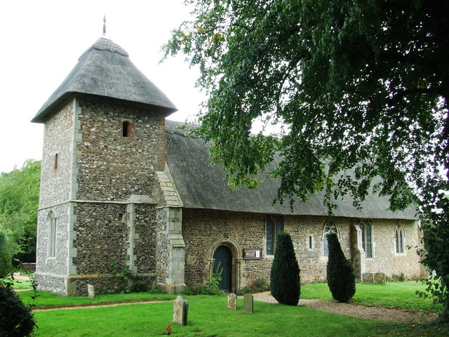


Why visit Eye
Townapedia lists 7 museums and landmarks, 3 parks and trails and 8 places to eat in and around town.
Highlights include Eye Priory, St Edmund's Monument, The Pennings, Eye and Mellis Common.
Weather in Eye
Forecast from MET Norway (CC BY 4.0). Full forecast
About Eye
Eye () is a market town and civil parish in the Mid Suffolk district, in the north of the English county of Suffolk, about 4 miles (6 km) south of Diss, 17.5 miles (28 km) north of Ipswich and 23 miles (37 km) south-west of Norwich. The population in the 2011 census of 2,154 was estimated to be 2,361 in 2019 and updated to 2,210 following the 2021 census. It lies close to the River Waveney, which forms the border with Norfolk, and on the River Dove. Eye is twinned with the town of Pouzauges in the Vendée department of France.
From the Wikipedia article Eye, Suffolk (this version), under CC BY-SA 4.0.
Travel tips from other travellers: Eye on Wikivoyage (CC BY-SA 4.0).
Museums and landmarks7
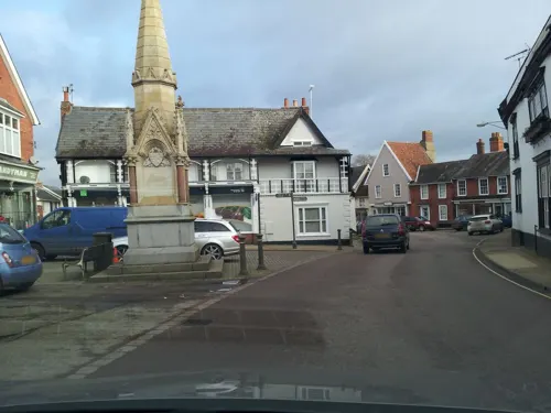

St Edmund's Monument
Monument and historic site · 2.9 mi
Memorial to St Edmund in Hoxne, Sussex, England, UK
War Memorial
Monument and historic site · 1.5 mi
Tall stone cross on engraved pedestal and plinth, in corner of graveyard near gate.
Parks, trails and playgrounds3


Restaurants and cafes8

Bruha Brewery
Brewery and winery · 1.0 mi
Formerly Station 1-1-9.
Unit 4 Progress Way, Eye


Churches and places of worship7

Church of St Peter and St Paul
Church
Grade I listed church in Eye, Suffolk, England, UK

St Mary's Church, Thornham Parva
Church · 2.4 mi
Church in Thornham Parva, Suffolk, England, UK


Church of St Michael
Church · 1.9 mi
Church in Occold, Suffolk, England, UK
History
There have been Palaeolithic, Mesolithic, Neolithic and Bronze Age finds in and around Eye, but the earliest evidence of settlement dates from the Roman period. It includes buildings and coins from about 365 CE. A large Anglo-Saxon cemetery with many urned cremations and some furnished inhumations, in use in the 6th century, was excavated near the Waterloo Plantation in 1818.
In 1781 labourers unearthed a lead box by the river at Clint Farm in Eye, 3 miles (4.8 km) south of Scole and 2 miles (3.2 km) south–west of Hoxne. It contained some 600 Roman gold coins from the reigns of Valens and Valentinian I (reigned 364–375), Gratian (375–383), Theodosius I (378–395), Arcadius (395–408) and Honorius (393–423).
Eye before the Norman Conquest was one of numerous holdings of Edric of Laxfield, a wealthy, influential Saxon, who was the third largest landholder in Suffolk. After the Norman Conquest, the town's regional importance was confirmed when the Honour of Eye was granted to William Malet, a Norman lord.
In 1066–1071, Malet built a castle as his military and administrative headquarters and started a market that initiated the urbanisation of Eye. In 1086–1087, William's son Robert Malet, tenant-in-chief of the Honour of Eye in the hundred of Hartismere, founded Eye Priory.
Read more of the history
Eye began to lose its strategic importance after 1173 when the castle was attacked by Hugh Bigod, 1st Earl of Norfolk during a rebellion against Henry II, and later during the Second Barons' War of 1265, after which it never regained its former status. Its prison continued in use up until the early 17th century, despite a programme of demolishing most of the castle buildings in the 14th century. A windmill built in 1561–1562 stood on the motte until a circular mock keep was built there in 1844.
Eye was once the smallest borough in the country, its claim based on the 1205 Charter of King John. The charter was renewed in 1408, then by Elizabeth I in 1558 and 1574, by James I in 1604, and by William III in 1697. However, in 1885 the town clerk of Hythe proved that the original charter belonged only to Hythe in Kent, the error having arisen from the similarity of the early English names, the error was confirmed by archivists in the 1950s but borough status was not discontinued until 1974. In 1835 Eye became a municipal borough which became part of the administrative county of East Suffolk in 1889, the district contained the parish of Eye. On 1 April 1974 the district was abolished and became part of Mid Suffolk in the non-metropolitan county of Suffolk. A successor parish was formed covering the same area as the former district and its parish. Eye retained a Town Council, a Mayor and its insignia. From 1571 to 1832 Eye returned two Members of Parliament (MPs), then after the Reform Act 1832, a single MP until 1983, when the Eye Constituency became the Suffolk Central constituency.
The notable Cornwallis family was established at nearby Brome Hall in the 14th century. Individuals from the family, such as Charles Cornwallis, 1st Marquess Cornwallis, represented Suffolk county in the House of Commons over the next three hundred years.
The Lordship of the Manor of Eye (Sokemere) and Constableship of the Castle is held by the Palmer family of Haughley in Suffolk. The current Lord is Kieron Palmer of Haughley, succeeding his father Kenneth Palmer. The Manor was held by the Malet family in Norman times, Henry Earl of Brabant, the De Ufford, De la Pole, Cornwallis and Kerrison families as well as King Stephen, Edward I, Mary I and Thomas Beckett in previous years. Known as the Honour of Eye, it consisted of 129 manors and had the right to a court of pie poudre at its Whit Monday market fairs and those of Thrandeston and Finningham.
The earliest mention of industry in Eye records that in 1673 "the women's employ in this town is making of bone lace" and in 1830, "the humbler class of industrious females employ themselves in lace making." It would appear that Eye was at the centre of a localised lace-making industry for many years. In 1846 Eye Borough Council failed in its attempt to route the new London-Norwich railway line through Eye. The line, completed in 1849, went instead through Diss, which was ensured growth in prosperity and population, while the importance of Eye waned. Eye railway station, at the end of a branch line from Mellis, closed to passengers in 1931 and to freight in 1964.
Eye Airfield, to the north-east of the town, began as RAF Eye, occupied by the 490th Bomb Group of the USAAF's VIII Bomber Command during the Second World War.
From the History section of Eye, Suffolk on Wikipedia, under CC BY-SA 4.0.
Notable people from Eye
 Stuart O'KeefeEnglish association football player (born 1991)Photo: Jon Candy from Cardiff, Wales, CC BY-SA 2.0
 William HoareBritish artist (1707-1792)Photo: William Hoare, Public domain
 Brian CapronBritish actorPhoto: AnemoneProjectors ( talk ) ( on Flickr ), CC BY-SA 2.0
 Charles CunninghamRoyal Navy admiral (1755-1834)Photo: Henry Wyatt, Public domain
- Matthew UpsonEnglish association football player (born 1979)
- Tim GilesEnglish jazz drummer
- John GowingAustralian businessman
- Geoff PymarBritish speedway rider
Born in Eye, according to Wikidata (CC0). Each name links to its Wikipedia article.
Shopping1
Gas and EV charging1
Schools, colleges and libraries4
Healthcare2
Map of Eye
33 places. The map loads OpenStreetMap tiles when you open it.
Getting there and nearby towns
RAF Honington (BEQ) is the nearest airport with scheduled flights listed in OpenStreetMap, 16 miles away.
- Scole 3 mi north, about 5 min by car
- Diss 4 mi north, about 7 min by car
- Dickleburgh 5 mi north, about 9 min by car
- Botesdale 6 mi west, about 10 min by car
- Rickinghall 7 mi west, about 11 min by car
- Banham 10 mi northwest, about 16 min by car
- Haughley 10 mi southwest, about 17 min by car
- Stowmarket 11 mi southwest, about 18 min by car
- Woolpit 13 mi southwest, about 21 min by car
- Ixworth 13 mi west, about 21 min by car
Drive times are estimates from straight-line distance, not routes.
Towns near Eye


Keep exploring
Local news
Headlines from INDB.
Reviews, tips and questions
Loading what members have shared...
Sources and licences
- GeoNames (CC BY 4.0): population, coordinates, regions and time zone
- Mapillary (see each image): photos
- OpenStreetMap contributors (ODbL 1.0): places, airports, map data
- Wikidata (CC0 1.0): elevation, founding date, time zone, website, landmarks and historic places
- Wikimedia Commons (see each image): photos
- Wikipedia (CC BY-SA 4.0): overview and history text
Photo credits
- Thornham Parva - Church of St Mary, Keith Evans, CC BY-SA 2.0
- 1316617 I CHURCH OF ST PETER AND ST PAUL, CHURCH STREET Eye 20260524 0015, Tilman2007, CC BY-SA 4.0
- Yaxley - Church of St Mary, Andrew Hill, CC BY-SA 2.0
- Gingerbread Man (6245568533), oatsy40, CC BY 2.0
- The Pennings, Eye 7, Dudley Miles, CC BY-SA 4.0
- Street-level photo, adam2, CC BY-SA 4.0
- Street-level photo, adam2, CC BY-SA 4.0
- Street-level photo, adam2, CC BY-SA 4.0
- Street-level photo, adam2, CC BY-SA 4.0
- Street-level photo, adam2, CC BY-SA 4.0
- Street-level photo, adam2, CC BY-SA 4.0
Page built November 10, 2026. Spotted a mistake? Tell us or suggest a place.