
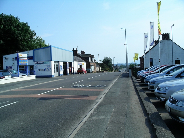


Locharbriggs, United Kingdom
Locharbriggs is a town of 5,960 people in Scotland, United Kingdom.
Why visit Locharbriggs
Townapedia lists 8 museums and landmarks, 2 parks and trails, 1 place to eat, 1 place to stay and 1 attraction in and around town.
Highlights include Theatre Royal, Dumfries, Dumfries and Galloway Aviation Museum, Dumfries Museum and The Pines Golf Centre.
Weather in Locharbriggs
Forecast from MET Norway (CC BY 4.0). Full forecast
About Locharbriggs
Locharbriggs is a village in Dumfries and Galloway, Scotland. It is located near the Lochar Water, 2.7 miles (4.3 km) north-northeast of the town of Dumfries. It was one of several villages that stood on the edge of the Lochar Moss which was largely reclaimed in the 19th century. The Locharbriggs locality (which also includes neighbouring Heathhall) had an estimated population of
From the Wikipedia article Locharbriggs (this version), under CC BY-SA 4.0.
Photos of Locharbriggs


Things to do1

Theatre Royal, Dumfries
Cinema and theater · 2.6 mi
Theatre in Dumfries, Scotland
Museums and landmarks8

Dumfries and Galloway Aviation Museum
Museum · 1.0 mi
Aviation museum in Dumfries, Scotland, United Kingdom

Gracefield Arts Centre
Museum · 2.2 mi
Museum in Dumfries and Galloway, Scotland, UK

Twelve Apostles Stone Circle
Monument and historic site · 2.7 mi
Stone circle at Newbridge, Dumfries and Galloway, Scotland, UK

Parks, trails and playgrounds2


Restaurants and cafes1
Where to stay1
Churches and places of worship3
St Bride's Anglican Church (former Greyfriars' Church), Church Crescent, Dumfries
Church · 2.5 mi
Gas and EV charging1
Schools, colleges and libraries3
Healthcare1
Map of Locharbriggs
21 places. The map loads OpenStreetMap tiles when you open it.
Getting there and nearby towns
Carlisle Lake District Airport (CAX) is the nearest airport with scheduled flights listed in OpenStreetMap, 33 miles away.
- Dumfries 3 mi southwest, about 4 min by car
- Lochmaben 6 mi east, about 9 min by car
- Lockerbie 9 mi east, about 15 min by car
- Thornhill 12 mi northwest, about 19 min by car
- Moffat 17 mi north, about 27 min by car
- Silloth 18 mi southeast, about 29 min by car
- Sanquhar 22 mi northwest, about 36 min by car
- Longtown 25 mi east, about 41 min by car
- Maryport 27 mi south, about 44 min by car
- Carlisle 29 mi southeast, about 47 min by car
Drive times are estimates from straight-line distance, not routes.
Towns near Locharbriggs


Keep exploring
Local news
Headlines from INDB.
Reviews, tips and questions
Loading what members have shared...
Sources and licences
- GeoNames (CC BY 4.0): population, coordinates, regions and time zone
- Mapillary (see each image): photos
- OpenStreetMap contributors (ODbL 1.0): places, airports, map data
- Wikidata (CC0 1.0): elevation, founding date, time zone, website, landmarks and historic places
- Wikimedia Commons (see each image): photos
- Wikipedia (CC BY-SA 4.0): overview and history text
Photo credits
- Locharbriggs, Lynne Kirton, CC BY-SA 2.0
- Shakespeare St, Dumfries, Contains Mild Peril ( talk ), CC BY-SA 3.0
- Dunfries and Galloway Aviation Museum Lightning F53, Expatscot, CC BY-SA 3.0
- Dumfries Museum Windmill tower at night, FutureMuseumSW, CC BY-SA 3.0
- Twelve Apostles Stone Circle 2017-05-16 - 1, August Schwerdfeger, CC BY 4.0
- Lincluden Collegiate Church - April 2008, Bubobubo2, CC BY-SA 3.0
- Burns Statue and Greyfriars, Dumfries, MSDMSD, CC BY-SA 3.0
- Jericho Loch (34944956513), James Johnstone from Ecclefechan, Scotland, CC BY 2.0
- Catch Of The Day - Flickr - TrotterFechan, James Johnstone from Ecclefechan, Scotland, CC BY 2.0
- Street-level photo, rudolfmayer, CC BY-SA 4.0
- Street-level photo, ccbb7766, CC BY-SA 4.0
- Street-level photo, hobgoblin, CC BY-SA 4.0

Page built November 10, 2026. Spotted a mistake? Tell us or suggest a place.