

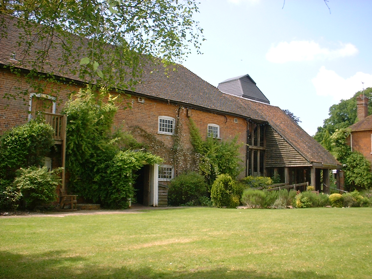


Why visit Newbury
Townapedia lists 23 museums and landmarks, 24 parks and trails, 117 places to eat, 10 places to stay and 6 attractions in and around town.
Highlights include Watermill Theatre, Corn Exchange, West Berkshire Museum and Donnington Castle.
Weather in Newbury
Forecast from MET Norway (CC BY 4.0). Full forecast
About Newbury
Newbury is a market town in West Berkshire, England, in the valley of the River Kennet. It is 26 miles (42 km) south of Oxford, 25 miles (40 km) north of Winchester, 27 miles (43 km) southeast of Swindon and 20 miles (32 km) west of Reading. It is also where West Berkshire Council is headquartered.
From the Wikipedia article Newbury, Berkshire (this version), under CC BY-SA 4.0.
Things to do6

Watermill Theatre
Cinema and theater · 1.8 mi
Theatre in Bagnor near Newbury, Berkshire, England, UK
Open in Google Maps · Wikipedia · +44 1635 45834;+44 1635 46044

Corn Exchange
Cinema and theater
Theatre and cinema in Newbury, England

Newbury Bridge
Bridge
Bridge over the River Kennet in Newbury, Berkshire, England, UK



Museums and landmarks23

West Berkshire Museum
Museum
Museum in Newbury, Berkshire, England, United Kingdom
The Wharf, Newbury
We-Su 10:00-16:00


Shaw House
Museum · 0.8 mi
Grade I listed historic house museum in West Berkshire, England, UK



Bussock Camp
Monument and historic site · 3.3 mi
Hillfort in West Berkshire, England, UK
Cruise missile shelter complex, Greenham Common Airbase
Monument and historic site · 1.9 mi

11 more on the map.
Parks, trails and playgrounds24


Nature Discovery Centre
Park · 2.2 mi
Nature reserve in Berkshire, England


Sandleford Priory
Park · 1.7 mi
Country house in Greenham, West Berkshire, England, UK
Snelsmore Common
Park · 2.5 mi
Nature reserve near Newbury, Berkshire
Thatcham Reed Beds
Park · 2.3 mi
Nature reserve in the United Kingdom county of Berkshire
12 more on the map.
Restaurants and cafes117
Mio Fiore
Restaurant · Italian Pizza, Italian
5 Inches Yard Market Street
Mo-Fr 12:00-22:00; Sa-Su 12:00-23:00

King's Café
Cafe
The Broadway, Newbury
Mo-Fr 07:00-16:00; Sa 07:00-15:00; Su 08:00-13:00

Caffè Nero
Cafe · Coffee Shop
86 Northbrook Street, Newbury
Mo-Fr 07:30-18:00; Sa 07:30-18:30; Su 08:30-17:30

Chilis Indian Restaurant
Restaurant · Indian
Station Approach, Newbury
Tu,Sa 17:00-22:00; Su 17:00-21:00

105 more on the map.
History
There was a Mesolithic settlement at Newbury. Artefacts were recovered from the Greenham Dairy Farm in 1963, and the Faraday Road site in 2002. Additional material was found in excavations along the route of the Newbury Bypass. Newbury was founded late in the 11th century following the Norman conquest as a new borough, hence its name. Although there are references to the borough that predate the Domesday Book it is not mentioned by name in the survey. However, its existence within the manor of Ulvritone is evident from the massive rise in value of that manor at a time when most manors were worth less than in Saxon times. In 1086 the Domesday Book assesses the borough as having land for 12 ploughs, 2 mills, woodland for 25 pigs, 11 villeins (resident farmhands, unfree peasant who owed his lord labour services), 11 bordars (unfree peasants with less land than villans/villeins), and 51 enclosures (private parks) rendering 70s 7d.
Read more of the history
Doubt has been cast over the existence of Newbury Castle, but the town did have royal connections and was visited a number of times by King John and Henry III while hunting in the area. The first reference to a bridge on the site of the current Newbury Bridge is an account of its reconstruction in the 14th Century. In 1312, King Edward II directed that its bridge should be kept in good order. By 1623, when the bridge collapsed, it was recorded as being built of wood, being 30 feet (9 metres) in length and 20 ft (6 m) in width, and having shops on it. The bridge was presumably rebuilt, as it is recorded that in 1644 a guard was placed on the bridge.
Historically, the town's economic foundation was the cloth trade. This is reflected in the person of the 16th-century cloth magnate, Jack of Newbury, the proprietor of what may well have been the first factory in England, and the later tale of the Newbury Coat. The latter was the outcome of a bet as to whether a gentleman's suit could be produced by the end of the day from wool taken from a sheep's back at the beginning. The local legend was later immortalized in a humorous novel by Elizabethan writer Thomas Deloney. Newbury was the site of two battles during the English Civil War, the First Battle of Newbury (at Wash Common) in 1643, and the Second Battle of Newbury (at Speen) in 1644. The nearby Donnington Castle was reduced to a ruin in the aftermath of the second battle. The disruption of trade during the civil war, compounded by a collapse of the local cloth trade in the late 16th century, left Newbury impoverished.
The local economy was boosted in the 18th century by the rise of Bath as a popular destination for the wealthy escaping London's summer heat and associated stench. Newbury was roughly halfway between London and Bath and an obvious stopping point in the two-day journey. Soon Newbury, and the Speenhamland area in particular, was filled with coaching inns of ever increasing grandeur and size. One inn, the George & Pelican, was reputed to have stabling for 300 horses. A theatre was built to provide the travellers with entertainment featuring the major stars of the age. In 1795 local magistrates, meeting at the George and Pelican Inn in Speenhamland, introduced the Speenhamland System which tied parish poor relief (welfare payments) to the cost of bread.
In 1723, the Kennet Navigation made the River Kennet navigable downstream from Newbury to the River Thames in Reading. Some 70 years later, in 1794, work started on the centre section of the Kennet and Avon Canal, which would extend the Kennet Navigation to Bath, thus providing a through water route between London and Bristol via Newbury. This route was finally completed in 1810. The opening of the Great Western Railway from London to Bath in 1841 effectively killed the canal and coaching trades, and as the line passed some 25 kilometres (15+1⁄2 mi) to the north it brought no advantage to the town. Newbury had to wait until 1847 to join the railway network, with the opening of the Berks and Hants Railway branch line from Reading to Hungerford via Newbury, and until 1906 to be on a main line, with the opening of the Reading-Taunton line. As a result, Newbury became something of a backwater market town, with an economy based largely on agriculture and horse-racing. The last use of the stocks in Newbury, and probably the UK, was on 11 June 1872 when Mark Tuck was placed in them for 4 hours. In the 1980s, British electronics firm Racal decided to locate their newly formed telecommunications company Racal Vodafone, later Vodafone UK, in the town. In the subsequent decades Newbury became something of a regional centre for the high-tech industries, and the town has since enjoyed a return to general economic prosperity.
A large Royal Air Force station was established during the Second World War in 1942 at Greenham Common on the edge of the town. In the 1950s, it became home to US Air Force bombers and tankers, for which it was equipped with the longest military runway in the United Kingdom. In the 1980s, it became one of only two USAF bases in the UK equipped with ground-launched nuclear-armed cruise missiles, causing it to become the site of protests by up to 40,000 protesters and the establishment of the Greenham Common Women's Peace Camp. With the end of the Cold War, the base was closed, the runway was broken up, much of it used as fill material in building the Newbury bypass, and the area was restored to heathland. This project then saw Greenham and Crookham commons reopened to the public in 2000.
From the History section of Newbury, Berkshire on Wikipedia, under CC BY-SA 4.0.
More about Newbury
Geography
The Civil Parish of Newbury consists of the town and the suburbs of Wash Common, The City, West Fields, East Fields and Speenhamland. The modern conurbation of Newbury, however, with close bus and road links and almost contiguous development, may be taken to include the surrounding villages of Speen, Donnington, Shaw and Greenham. Speen, which is now a suburb of western Newbury, is roughly equidistant between Bristol and London.
Elevations vary from a minimum of 72 m above mean sea level to 122 m at Wash Common. Elevations reach 150–200 m in the directly adjoining hills. The River Kennet and the Kennet and Avon Canal flow east through the centre of the town to reach the Thames at Reading, while the River Lambourn (beside which is the country's largest horse-training paddocks in the Valley of the Lambourn Downs) partly forms its northern boundary, ending in the town. A tributary that is smaller still, the River Enborne, forms the southern boundary (and also the county boundary with Hampshire).
Economy
Newbury and its immediate surroundings constitute the major commercial and retail centre of West Berkshire. The local economy is inter-related to that of the eastern M4 corridor which has most of its industrial, logistical and research businesses close to Newbury, Reading and Slough, with smaller industrial estates in the county at Theale, Bracknell and Maidenhead. Newbury is home to the United Kingdom headquarters of the mobile network operator Vodafone, which is the town's largest employer with over 6,000 workers. Before moving to their £129 million headquarters in the outskirts of the town in 2003, Vodafone used 64 buildings spread across the town centre.
As well as Vodafone, Newbury is also home to the United Kingdom headquarters of National Instruments, Stryker Corporation, EValue, and the Newbury Building Society. The pharmaceutical company Bayer AG are also headquartered in the town, although in October 2015 the company announced their intention to move to the Green Park Business Park near Reading.
Education
St. Bartholomew's School – one of the oldest schools in Berkshire, founded in 1466.
Trinity School, formed after the closure of Shaw House School and Turnpike School.
There is also Newbury College, a further and higher education college, funded by a private finance initiative, and Mary Hare School, a residential co-educational community special needs school for deaf pupils.
Horris Hill, an all-boys day and boarding school (from ages 4 to 13; boarding from 7 to 13)
Thorngrove School, a day co-educational school in nearby Highclere (from the ages 2½ to 13)
From the Wikipedia article Newbury, Berkshire, under CC BY-SA 4.0.
Notable people from Newbury
 Luke HumphriesEnglish darts player (born 1995)Photo: Sandro Halank, Wikimedia Commons, CC BY-SA 4.0
 John Newport LangleyBritish physiologist (1852-1925)Photo: Unknown author Unknown author, CC BY 4.0
 Stewart RomeBritish silent movie actor (1886-1965)Photo: YellowFratello, CC BY-SA 4.0
 John Septimus Roefirst Surveyor-General of Western Australia and explorer (1797-1878)Photo: Moondyne, CC BY-SA 3.0
 William TwisseWestminster DivinePhoto: Gustavus Ellinthorpe Sintzenich, Public domain
 Charlotte PayneBritish hammer thrower (born 2002)Photo: Bearas, CC BY-SA 4.0
 Rosemary HayesBritish writerPhoto: Troglopedetes, CC BY-SA 4.0
- Richard AdamsEnglish novelist best known as the author of Watership Down
- Michael BondBritish writer (1926–2017)
- Francis BailyBritish astronomer
- Edward Charles TitchmarshBritish mathematician (1899-1963)
- Albert Bruce JacksonBritish dendrologist (1876-1947)
Born in Newbury, according to Wikidata (CC0). Each name links to its Wikipedia article.
Where to stay10
Churches and places of worship23
The Church of Jesus Christ of Latter-day Saints
Church · Latter Day Saints · 1.4 mi
Pinchington Lane, Newbury
Shopping31
Gas and EV charging6
Schools, colleges and libraries23
St John the Evangelist CofE Infant and Nursery School
School · Anglican · 0.7 mi
Old Newtown Road, Newbury
Healthcare6
Map of Newbury
250 places. The map loads OpenStreetMap tiles when you open it.
Getting there and nearby towns
RAF Benson (BEX) is the nearest airport with scheduled flights listed in OpenStreetMap, 18 miles away.
- Thatcham 3 mi east, about 4 min by car
- Tadley 9 mi southeast, about 15 min by car
- Basingstoke 14 mi southeast, about 23 min by car
- Wantage 14 mi north, about 22 min by car
- Didcot 15 mi north, about 24 min by car
- Reading 16 mi east, about 25 min by car
- Wallingford 16 mi northeast, about 26 min by car
- Lower Earley 18 mi east, about 28 min by car
- Tidworth 19 mi southwest, about 30 min by car
- Swindon 22 mi northwest, about 36 min by car
Drive times are estimates from straight-line distance, not routes.
Towns near Newbury


Keep exploring
Local news
Headlines from INDB.
Reviews, tips and questions
Loading what members have shared...
Sources and licences
- GeoNames (CC BY 4.0): population, coordinates, regions and time zone
- Mapillary (see each image): photos
- OpenStreetMap contributors (ODbL 1.0): places, airports, map data
- Wikidata (CC0 1.0): elevation, founding date, time zone, website, landmarks and historic places
- Wikimedia Commons (see each image): photos
- Wikipedia (CC BY-SA 4.0): overview and history text
Photo credits
- Newbury market place, Brian Robert Marshall, CC BY-SA 2.0
- Watermill Theatre, Bagnor, Sheps at English Wikipedia, Public domain
- The Granary, Wharf Street, Newbury (1), Tom Bastin from Reading, UK, CC BY 2.0
- Shaw House, Berkshire 05, Simon Burchell, CC BY-SA 4.0
- Victoria Park - Newbury, Unknown author, CC BY-SA 2.0
- St John the Evangelist, Newbury, Bill Boaden, CC BY-SA 2.0
- Thatcham Church in winter, Marc Evans from Reading, England, CC BY-SA 2.0
- St Nicholas, Newbury, Tom Bastin from Reading, UK, CC BY 2.0
- Sandleford Priory (west front), Sandleford, Greenham, Newbury, Berkshire, England, Rodolph, CC BY-SA 3.0
- Donnington Castle - April 2005, Unknown author, CC BY-SA 2.0
- Plan of the Second Battle of Newbury, Walter Money and C.K.K. (1879); Whiteman and Bass Photo-Lithography, High Holborn, London, Public domain
- Benham Valence - Mansion House, Ringer Jake, CC BY-SA 4.0
- Newbury Methodist Church, 56 Northbrook Street, Newbury, Berkshire, Mertbiol, CC0
- Newbury Town Hall, Tom Bastin from Reading, UK, CC BY 2.0
- King's Coffee House, Ittykutty, CC BY-SA 4.0
- The Chequer's Hotel, 6-8 Oxford Street, Newbury, Berkshire, Mertbiol, CC0
- The Corn Exchange and The Elephant at the Market, Newbury, Simon Burchell, CC BY-SA 4.0
- Newbury War Memorial, Tom Bastin from Reading, UK, CC BY 2.0
- St Joseph's Church, Newbury, Mertbiol, CC0
- Audrey's Meadow (1), Dudley Miles, CC BY-SA 4.0
- The Corn Exchange, Newbury, Tom Bastin from Reading, UK, CC BY 2.0
- Newbury Bridge - panoramio, mattgirling, CC BY-SA 3.0
- Aerial view of Rack Marsh, Bagnor, Matthew Prior, CC BY-SA 4.0
- The Nature Discovery Centre, winter, Marc Evans from Reading, UK, CC BY-SA 2.0
- Street-level photo, dcp, CC BY-SA 4.0
- Street-level photo, wdolphin, CC BY-SA 4.0
- Street-level photo, wdolphin, CC BY-SA 4.0
- Street-level photo, themadcabbie, CC BY-SA 4.0
- Street-level photo, southglos, CC BY-SA 4.0
- Street-level photo, jpennycook, CC BY-SA 4.0
- Street-level photo, southglos, CC BY-SA 4.0
- Street-level photo, southglos, CC BY-SA 4.0
- Street-level photo, themadcabbie, CC BY-SA 4.0
- Street-level photo, wdolphin, CC BY-SA 4.0
- Street-level photo, themadcabbie, CC BY-SA 4.0
- Street-level photo, themadcabbie, CC BY-SA 4.0
- Street-level photo, themadcabbie, CC BY-SA 4.0
- Street-level photo, RyanBush, CC BY-SA 4.0
- Street-level photo, southglos, CC BY-SA 4.0
- Street-level photo, southglos, CC BY-SA 4.0
- Street-level photo, southglos, CC BY-SA 4.0
- Street-level photo, southglos, CC BY-SA 4.0


Page built November 10, 2026. Spotted a mistake? Tell us or suggest a place.