


Prestwick, United Kingdom
Prestwick is a town of 14,880 people in Scotland, United Kingdom.
Why visit Prestwick
Townapedia lists 19 museums and landmarks, 10 parks and trails, 124 places to eat, 9 places to stay and 3 attractions in and around town.
Highlights include Gaiety Theatre, Ayr, The Pavilion, Shaw Monument and Macrae's Monument.
Weather in Prestwick
Forecast from MET Norway (CC BY 4.0). Full forecast
About Prestwick
Prestwick (Scottish Gaelic: Preastabhaig) is a town and former royal burgh in South Ayrshire on the west coast of Scotland. It adjoins the larger town of Ayr to the south on the Firth of Clyde coast, the centre of which is about two miles (three kilometres) south, and the small village of Monkton to the north. It had a population of 14,570 in 2022. The town was the first home of the Open Golf Championship, which was played on the Prestwick Old Course from 1860 to 1872.
From the Wikipedia article Prestwick (this version), under CC BY-SA 4.0.
Travel tips from other travellers: Prestwick on Wikivoyage (CC BY-SA 4.0).
Photos of Prestwick


Things to do3
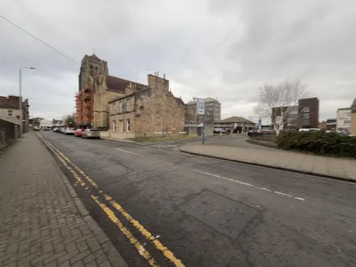
Gaiety Theatre, Ayr
Cinema and theater · 1.6 mi
Theatre in Ayr, Scotland

The Pavilion
Cinema and theater · 1.8 mi
Former music venue in Ayr, Scotland, now used as a family entertainment centre

Museums and landmarks19

Shaw Monument
Monument and historic site · 1.7 mi
Monumental tower in South Ayrshire, Scotland, UK


Macrae's Monument
Monument and historic site · 2.8 mi
Monument in South Ayrshire, Scotland, UK

7 more on the map.
Parks, trails and playgrounds10



The Oval
Park · 0.7 mi
Public park in Prestwick, South Ayrshire, Scotland, UK
Restaurants and cafes124


The Smoking Goat
Bar and pub · 1.5 mi
2a Academy Street, Ayr
Mo-Th 12:00-00:30; Fr-Sa 12:00-01:00; Sa 12:00-00:30

Lychees Ayr
Restaurant · Chinese · 1.4 mi
42 South Harbour Street, Ayr
We,Th 12:00-14:00,17:00-22:00; Fr,Sa 12:00-22:00; Su 14:30-22:00

112 more on the map.
History
Prestwick's name comes from the Old English for, priest's farm: preost meaning "priest" and wic meaning "farm". The town was originally an outlying farm of a religious house. George T. Flom suggested that the name was of Old Norse origin. In this case, it would mean "priest's bay".
Robert the Bruce is reputed to have been cured of leprosy by the waters of the well at St Ninians church. The well still exists behind the church.
Although it has been a Burgh of Barony for over a thousand years, it was a village until the railway arrived in the 1840s and the middle class from Glasgow started to build large houses along the coast. Prestwick Burgh Hall was completed in around 1837.
The Prestwick Bathing Lake, known as the Lido, was opened in 1931 by the Secretary of State for Scotland, William Adamson. It was the largest swimming pool north of the border. It could accommodate 1200 bathers and 3000 spectators. It hosted swimming galas, diving exhibitions, moonlight swimming sessions and regular fireworks displays and was the venue of some of the Miss Scotland competitions. It was closed in 1972 and subsequently demolished.
On 28 August 1944, a Douglas C-54 Skymaster (42-72171) of the United States Army Air Forces, on approach into Glasgow Prestwick Airport in bad weather, crashed into a residential area of Prestwick, killing all 20 passengers and crew and five people on the ground.
From the History section of Prestwick on Wikipedia, under CC BY-SA 4.0.
More about Prestwick
Arts and culture
St. Ninian's Park, nicknamed The Oval, is a public park located in the centre, and consists of 2 full size football pitches with indoor changing rooms, a tennis centre with 3 indoor courts and 8 outdoor, a 25m indoor swimming pool and gym, indoor bowling green and cricket club. Famous sportspeople from Prestwick are footballers Bob Anderson, Craig Conway, James Forrest, Giovanni Moscardini, Andrew Thomson, footballer turned MP Ian Welsh, professional wrestler Drew McIntyre, professional golfer William McGowan and figure skater Lewis Gibson.
Prestwick Golf Club is a classic links golf course, built on the rolling sandy land between the beach and the hinterland. The course is near the Prestwick airport, and some holes run along railway tracks on the eastern side of the course. The Open Championship originated at the club, and was played there 24 times between 1860 and 1925.
From the Wikipedia article Prestwick, under CC BY-SA 4.0.
Notable people from Prestwick
 James ForrestScottish association football player (born 1991)Photo: Ailura, CC BY-SA 3.0 at
 Jenny ColganBritish writerPhoto: Jindřich Nosek (NoJin), CC BY 4.0
- Lewis GibsonBritish figure skater and ice dancer
- Scott AndrewsScottish and British curler
- Ian BarghCanadian jazz pianist (1935–2012)
- Scott AgnewScottish footballer (born 1987)
- John AnsticeBritish Army general
- David WatsonScottish footballer (born 2005)
- Nora E. ScottAmerican Egyptologist (1905–1994)
- Bob AndersonEnglish footballer (1924-1994)
- Ciara TorranceScottish badminton player
- Ian WelshScottish politician (born 1953)
Born in Prestwick, according to Wikidata (CC0). Each name links to its Wikipedia article.
Where to stay9
Churches and places of worship25
Darlington New Church of Scotland
Church · Church Of Scotland · 1.3 mi
Main Street, Ayr
Shopping28
Gas and EV charging3
Schools, colleges and libraries12
Healthcare6
Map of Prestwick
239 places. The map loads OpenStreetMap tiles when you open it.
Getting there and nearby towns
Glasgow Prestwick Airport (PIK) is the nearest airport with scheduled flights listed in OpenStreetMap, 2 miles away.
- Ayr 2 mi southwest, about 3 min by car
- Troon 5 mi northwest, about 7 min by car
- Saltcoats 12 mi northwest, about 20 min by car
- Renfrew 28 mi north, about 45 min by car
- Rutherglen 29 mi northeast, about 46 min by car
- Glasgow 30 mi northeast, about 48 min by car
- Wishaw 34 mi northeast, about 54 min by car
- Stranraer 43 mi south, about 1 h 15 min by car
- Whitburn 45 mi northeast, about 1 h 15 min by car
- Stirling 51 mi northeast, about 1 h 15 min by car
Drive times are estimates from straight-line distance, not routes.
Towns near Prestwick


Keep exploring
Local news
Headlines from INDB.
Reviews, tips and questions
Loading what members have shared...
Sources and licences
- GeoNames (CC BY 4.0): population, coordinates, regions and time zone
- Mapillary (see each image): photos
- OpenStreetMap contributors (ODbL 1.0): places, airports, map data
- Wikidata (CC0 1.0): elevation, founding date, time zone, website, landmarks and historic places
- Wikimedia Commons (see each image): photos
- Wikipedia (CC BY-SA 4.0): overview and history text
Photo credits
- Prestwick from the air 1, Unknown author, CC BY 2.0
- 05193 New Prestwick Baptist Church, Prestwick Road, Ayr 008, WeeHolly, CC BY-SA 4.0
- 05193 New Prestwick Baptist Church, Prestwick Road, Ayr 006, WeeHolly, CC BY-SA 4.0
- 05193 New Prestwick Baptist Church, Prestwick Road, Ayr 004, WeeHolly, CC BY-SA 4.0
- 05193 New Prestwick Baptist Church, Prestwick Road, Ayr 001, WeeHolly, CC BY-SA 4.0
- 05193 New Prestwick Baptist Church, Prestwick Road, Ayr 009, WeeHolly, CC BY-SA 4.0
- 05193 New Prestwick Baptist Church, Prestwick Road, Ayr 003, WeeHolly, CC BY-SA 4.0
- 05193 New Prestwick Baptist Church, Prestwick Road, Ayr 007, WeeHolly, CC BY-SA 4.0
- 05193 New Prestwick Baptist Church, Prestwick Road, Ayr 010, WeeHolly, CC BY-SA 4.0
- 05193 New Prestwick Baptist Church, Prestwick Road, Ayr 002, WeeHolly, CC BY-SA 4.0
- 05193 New Prestwick Baptist Church, Prestwick Road, Ayr 005, WeeHolly, CC BY-SA 4.0
- 10920 Ex Waterloo Road Brethren Hall, Prestwick 001, WeeHolly, CC BY-SA 4.0
- Ayr Pavilion from east, Iroberts696, CC BY-SA 4.0
- Shaw Monument - North Facing side, Rosser1954 Roger Griffith, CC BY-SA 3.0
- Auld Kirk Of Ayr - gable, Iroberts696, CC BY-SA 4.0
- AyrRCCathedral, JohnArmagh, Public domain
- SomersetPark, Martin Le Roy, CC BY 2.5
- Prestwick Academy, Billy McCrorie, CC BY-SA 2.0
- Prestwick Academy From The Air, Martin Le Roy, CC0
- Somerset Park, Ayr, August 2024, Goodreg3, CC0
- Loudoun Hall, Iroberts696, CC BY-SA 4.0
- Street-level photo, noid, CC BY-SA 4.0
- Street-level photo, noid, CC BY-SA 4.0
- Street-level photo, xdTAGCLAN, CC BY-SA 4.0
- Street-level photo, southglos, CC BY-SA 4.0
- Street-level photo, southglos, CC BY-SA 4.0
- Street-level photo, southglos, CC BY-SA 4.0
- Street-level photo, rudolfmayer, CC BY-SA 4.0
- Street-level photo, southglos, CC BY-SA 4.0
- Street-level photo, plan_c, CC BY-SA 4.0
- Street-level photo, rudolfmayer, CC BY-SA 4.0
- Street-level photo, albertdougie15, CC BY-SA 4.0
- Street-level photo, albertdougie15, CC BY-SA 4.0
- Street-level photo, albertdougie15, CC BY-SA 4.0
- Street-level photo, albertdougie15, CC BY-SA 4.0
- Street-level photo, southglos, CC BY-SA 4.0
- Street-level photo, gmc, CC BY-SA 4.0
- Street-level photo, southglos, CC BY-SA 4.0
- Street-level photo, rudolfmayer, CC BY-SA 4.0
- Street-level photo, rudolfmayer, CC BY-SA 4.0


Page built November 10, 2026. Spotted a mistake? Tell us or suggest a place.